Showing posts with label Vernal Pools. Show all posts

Saturday, May 3, 2014

The San Jacinto River Valley that Juan Bautista de Anza saw

Nature's Army Corp of Engineering of a Riverbed
I am writing this post extra (which is one of three extras aside from the main post) as a side addition to my main final of three Anza Expedition posts which I have previous written with regard the series of events recorded in the journals of Juan Bautista de Anza, Fray Pedro Font and Friar Francisco Garcès. I want to briefly veer off the record of the Spanish Explorer's trek to give readers a visual of what the natural world (were it not for the natural world observations recorded by these men, I would have never created these posts) in the San Jacinto Valley may have possibly looked like when these explorers found & saw it for the first time based on what they wrote and what my own experience of this area tells me. Along with their written observations, there is also still some physical forensic evidence of sorts to back up those observations and verify what once was by making some present comparisons with other existing riparian wetland habitats. I want this post here to illustrate the mechanisms and/or  the geological nature of what was observed and certain natural forces which maintained such a once beautiful ecosystem which has been systematically dismantled and obliterated in the name National economic interests. Our entire Earth suffers under all the National Interests of each & every Sovereignty dominating the globe which has resulted in the present climatic mess we find ourselves fighting and struggling to survive in, all the while trying not to cut more holes than absolutely necessary in our own economic safety nets.
Credit: Riverside County Flood Control
Okay, let's talk historic flood plains and the ancient river channels. Well, let's just deal with one which is a mere whimper of it's former grand self. This is an aerial photo of the flooding in the vicinity of State Street (Highway 74) and Ramona Expressway,  February 21, 1980, as a result of the breach of the San Jacinto River Levee just east of the city of San Jacinto in the eastern part of the valley near Soboba Indian Reservation on the north & west of Valle Vista where the concrete lined Bautista Creek Flood Channel enters the San Jacinto River. In most of the literature about the Anza Expedition's entrance into the Hemet or San Jacinto Valley, the mention is made of the Anza Party coming out onto the banks of the San Jacinto River as being the area of present day Valle Vista (Fremont St & Hwy 74) which is actually east of present day Hemet on Florida Avenue. This is misleading because while Anza's group did follow the Bautista Creek riverbed, the present day concrete flood control channel is NOT the original creekbed. The channel was moved further east as a means of convenience (like most human endeavors) to protect Agricultural economic interests. The original natural meandering creek bed route is actually still present and visible, although no water ever flows in it anymore with the except perhaps of some localized street runoff from storms. The original route of Bautista Creek angled more northwesterly brushing close to Park Hill which is centered in the triangle of Hemet-San Jacinto- Valle Vista. It was at a short spitting distance so to speak that old historic Bautista Creek entered the San Jacinto River main channel. 


Image: Melody Mcfarland

Bautista Canyon Flood Basin
The present day concrete lined Bautista Flood Channel is attached to the upstream flood control catch basin dam within Bautista Canyon and it's outflow into the San Jacinto river is much further east than the old historic creek bad which is directly north of Valle Vista. Before I help you appreciate a visual of what this valley use to look like based on the journals of Anza and his companions, I want to deal with a few mechanical or physical details of the river's original historic route and the massive flood plain that supported such an extensive flora which was described by these men. The breach in the River's levee actually helps us to retrace that original route and helps us better understand what the Explorers saw and wrote about. Mainly, what they described was a riparian ecosystem which no longer exists and is tough to sell a public who is incapable of visualizing such a system as existing in what they consider nothing more than desert. This is a familiar story which is told 100 times over & over all around our globe where wetlands in the early days were regarded as of little or no value and only impeded human economic endeavors. Even as a kid in elementary school, the so-called miracle of the capital city Brasília was hailed as a success story of land reclamation from worthless rainforest swampland which we call the Amazon River Basin. I have never liked the historical use of the term "Land Reclamation" where human removal of the various components of the planet's natural world is considered a vast improvement. All of Earth's riparian systems in this case the importance of water reclamation, filtration along with important wildlife habitat which enhances self-sustaining maintenance are important learning tools for the discipline of Biomimetics. Take a look at this animated image below which illustrates exact location of 1980 flood water breach of the river levee. 


image: Riverside County Flood Control

Photo: Mine (2013)

Ramona Expressway & Levee
This is a map drawn up to illustrate the exact point of levee breach and the San Jacinto River's re-entry into it's former historical flood plain route. How does that saying about water's behavior go again, "Path of Least Resistance" ? Today the breach has long been repaired, upgraded and where now there was once open countryside next to the river's edge, there are now numerous housing tracts. Seriously, look the spot up on Google Earth and see for yourself what progress is all about. This goes a long way in revealing the true nature about why it is justified that Nature needs to be bridled and harnessed to protect people. What do you want to bet the developer got the land cheap ? What do you also want to bet that most of those home buyers didn't do their own due diligence homework of the area's history ?  BTW, I have posted a great link at the bottom put together on the Floods of February in Riverside County 1980. Just click the link at the bottom. Great photos and history.


photo: Riverside Flood Control

Notice also how close the proximity of this breach is to the present day outflow of the modern realigned concrete-lined Bautista Flood Channel just east ? Also notice directly opposite of that Bautista outflow channel where another stream bed feature emerges from the mountains from the north ? It is listed on that map as Castile Creek, but is otherwise known as Poppet Creek which flows through what is known as Castile Canyon which is behind the Soboba Indian Reservation. But the mouth of Bautista Creek which is presently held in check by the flood control basin allows for an ocean of Citrus Orchards which still exist today in southeastern Hemet Valley south of Valle Vista. The view below is an aerial view of this region looking from east to west in the southern Hemet Valley.


Image: Michael Layefsky

This area may have been the direction of the second branch of the Bautista Creek stream bed which Fray Pedro Font wrote about when they emerged from the mouth of Bautista Canyon onto the Bajada flood plain where he said the stream disappeared into the sand a ways downstream. Clearly this specific location above would be a logical point at which the dividing of the water stream bed would explain the stream moving underground at some point into the sandy wash. It also would have been a well watered region with water tables near the surface allowing for any riparian and oak woodlands to exist here. This second stream channel's westerly direction would also have contributed to south and west Hemet Valley's Vernal Pools  once it passed the Park Hill are and possibly doubled back during high flooding seasons. This stream course would have also helped other surface wetlands which allowed for the profusion of wildflower displays described immediately seen by all the Anza Expedition journal writers who mentioned not only the wildflowers, but also the Geese and other waterfowl from the moment they emerged from Bautista Canyon. 


Image: Michael Layefshy

This image above by Michael Layefsky is of the Bautista Creek Flood Control Channel which was redirected more north and east from it's historic further west course. He describes it as an irrigation canal, but the real irrigation canal which siphons and sucks water from the San Jacinto River Canyon at three locations is the thin concrete channel line which runs from right to left in the image crossing the Flood Channel. There are many other hydrological components up & down stream which also contributed to the San Jacinto River's water flooding when it occurs. All of the journals speak of these other tributaries as well, especially regarding their importance in helping to fill Mystic Lake. I briefly wrote about one of these called Portero Creek which runs from the north out of the San Gorgornio Mountains north of present day Beaumont which itself is north of the San Jacinto Valley. 
Lessons Learned from the Bajadas (Alluvial Fans)
The aerial photograph of the city of San Jacinto flooding at the very top of this post merely illustrates the more direct route taken by the 1980 flood which in reality was merely back into it's old original historic water course as it made it's way in a more beeline fashion to Mystic Lake and present day community of Lakeview. The map below here I created from Google Earth to illustrate with coloured pins to give an idea of both the historic and modern river stream bed routes. You can actually click on any of these images to blow them up bigger to get the full flavour of what I am referring to. Red Pins illustrates the original channel along with the present concrete Bautista Flood Channel and the two rows of blue pins actually represent both divided channels of Bautista Creek which Fray Pedro Font made reference to. The Bautista wash which can still be found on modern maps are represented by blue pins on the right, with the older original historical channel on the left and west of Park Hill.


image animation, Google Earth

Below is the image I created from Google Earth to illustrate the western route of Bautista Creek into a more westerly confluence into the San Jacinto River Valley. The intense probability of this valley being a major wetlands system was huge and the natural vegetative potential for which all of these men wrote about, although at times varying from one another is also born out by the geographical facts which still exist as a testament today. The beauty of several journals being written about the same event, is not that they conflict with one another, but rather compliment each other. Each one has personal tastes and points of view that interest them. While some may have seen the very observations someone else wrote of, others noted down other important factors which contributed to a more complete picture which gives us a richer picture of a extinct landscape which no longer exists, but clues perhaps of how to put things back together again with a little practical application if one has a mind to do such. Again, click on image for zoom feature.


image animation: Google Earth


This Google Earth image shows  old historic Bautista Creek bed at the bottom marked with Blue Pins and new concrete lined Flood Control Bautista Channel with Red Pins at the right hand side. I have also added other Blue Pin Stars to mark the western boundary of another possible route of the second channel mentioned by Pedro Font in his journal where Bautista Creek was said to branch into two separate channels where water disappeared into the sand. The orignal Park Hill Anza Monument was on this western side on Park Ave. Park Hill is at left of the channel marked with the Yellow Pin and the larger Darker Red image is where the breach in the levee of the San Jacinto River flood control levee took place in 1980. This follows due west-northwest by a line of other Red Pins which shows the main route of floodwater flow which took a more direct line through downtown San Jacinto through older Ramona Expressway on it's route to Mystic Lake. But the actual flooding was spread out over a few miles wide as the valley floor is so perfectly flat. Only the building and other man made features would have offered flooding variables here and there. That would have been the historical pattern a few centuries back with the natural riparian vegetation offering a few meandering hicups here and there. Above right is an image of the repair work being done on that breach all the way down to the Gilman Springs Road bridge over the San Jacinto River. But there are also other maps I have created and found which add to unlocking the mystery of what this valley was once capable of creating and maintaining from a wild ecosystem perspective. 


Image: Google Earth


This Google Earth image above is Park Hill with the city of San Jacinto to the north, with both the city of Hemet to the west and Valle Vista to the east, but  out of the image. There use to be a Anza Expedition camp   Monument somewhere along Park Avenue's western edge which runs a clear circle around Park Hill. The monument was a testimony to the encampment of Juan Bautista de Anza and his expeditionary party, although it could also have been on the eastern side of Park Hill where they would have come in from the southeast following the old Bautista Creek channel just on the eastern side of this hill. From the description of all the men who wrote in their respective journals about the dense old growth of riparian forests and other riparian vegetation which made it almost impossible to navigate, it would have made logical sense to climb these small group of hills to get one's bearings and a better perspective of which direction to head. That's what I would have done. I mean it makes geographical sense before proceeding ahead. Now imagine for a moment you are at the top of the tallest point on those hills. Imagine for a moment in your mind's eye, that all the human clutter of infrastructure in the above Google image doesn't exist yet. Rather, an  entire ocean of lush green runs from the foot of Park Hill to the foot of the far steep slopes of North Mountain in the distance. Riparian woodlands would also be running from the mountains of San Jacinto to just a mile or so beyond the present day Hwy 79 (Sanderson Ave). It would have been up here on this bird's eye view where they would have been struck with awe of the overwhelming beauty of such a place which inspired them to naming it at first, "Paradise Valley" and for a multitude of sound reasons. 


West Hemet Goldfield wildflowers once 
a more common occurrence than it is today 
being replaced with Houses & Industrials.
All three Journal writers made numerous references to the mass of wildflower displays they all observe everywhere since they first hit the mountains from the Deserts below. For example, in my other post, I mentioned the overwhelming beauty of Goldfields which were/are extremely common in Western Riverside County. During the wettest periods there has historically always been a profusion of a wildflower show in all directions from western Hemet Valley to well beyond the regions west of Winchester California. Had they stood on top of Park Hill and spun around to the west and south, they would have been overwhelmed by the richness and completeness of the colour displays of not only Goldfields, but large patches of the purple of Owl's Clover. But there is far more. Add in splashes of a mosaic pattern of countless shallow vernal pools stretching all the way from Central Hemet to Winchester and beyond reflecting clear baby blue sky in fresh air and you're further blown away. But wait, look back to the north again. 


Temecal Canyon hillside California Poppies
and what North Mountain also would have
appeared to the
Spanish explorers
The brilliant blindingly beautiful California Poppies on the steep geography of the south facing  slopes of North Mountain along the northern edge of San Jacinto Valley where Gilman Springs and Soboba Roads run along the foot of these steep slopes and present day human realigned river bed. In my own personal experience of living around there for 20+ years, I witnessed with every wet year almost every square foot of those steep slopes as having solid orange in the past. So bright and brilliant were the intensity of the colours and sun's light reflecting off those flowers, that you truthfully needed sunglasses to view them more easily. While I have no photos of this, you can get a sense of what they would look like by driving through Temescal Canyon on the I-15 Freeway driving north from Lake Elsinore to Corona every Spring. The photo above left is an example of such poppy covered steep slopes. While the above photo doesn't describe what I have seen all along the southern face of North Mountain, it is a slight glimpse of what these men all saw in mass display which inspired them to make special note numerous times in their daily journals. Clearly it is also a topic all of them would have talked about among themselves, how could you not ? Below is another Google Earth image I created to show the San Jacinto River Valley from a west to east vantage point. Notice the steep slopes of North Mountain to the north side of the valley where the California Poppies have traditionally flourished in exceptionally wetter rainfall periods. 


Image: Google Earth
The area above is very notorious for flooding even when there isn't any breach in an upstream levee. In actual fact, even a summer time a localized torrential downpour of some monsoonal Thunderstorm event can even inundate this area in a deluge within minutes. Numerous times during my more than 20+ years living around there, the roads were closed from Springtime for months and not reopened until summer. For example, I seemed to remember Sanderson Avenue which runs from south of Hemet and technically now is the official Hwy 79 to Beaumont would be closed for almost an entire year because of the San Jacinto River running full force one entire year. This was because North Sanderson Avenue had no four-lane Freeway styled Bridge as it does now. The road went down into an extremely wide floodplain wash. Traffic was rerouted through Hemet-San Jacinto on State Street, then on north over the old Gilman Road Iron Truss bridge which crossed San Jacinto River onto Gilman Springs Rd west to Lamb's Canyon Rd (Hwy 79) to Beaumont/Banning. The farmland almost everywhere back in the early/middle 1980s for the most part were numerous shallow lakes kept full by the river feeds and backwaters. Below here is a map I found on an older archived Press Enterprise article about the proposals for  improvements being made to the San Jacinto River Levee which should in theory alleviate future flooding problems. Notice existing drainage canals are red lines and newer proposed drainage ditches are the blue line ? This is because this entire valley is so flat that water has no where else to go once it arrives there. Also take special note of the outer perimeter black border outline. Also take special note of the possible far western extent of an ancient Bautista Creekbed (which no longer exists). This link below I have created to explain and show by references just where that creek route existed and where it meandered around to the western side of Park Hill: This is one of the Bautista Creek flanks Fray Pedro Font made reference to and he was the only one, but what a valuable piece of info as it explains much about the area's flood history.
~~~~~~~~~~~~~~~~~~~~~~~~~~~~~~~
An important side reading:
Old Bautista Creek Channel Eastside & Westside Branches
~~~~~~~~~~~~~~~~~~~~~~~~~~~~~~~
Animated Image Map: Press Enterpise

SAN JACINTO: Council to consider updating drainage facilities plan

Image, P.E.
There was another image a year later which showed the same familiar channel region in blue where they were determined to force the river in check. As you can see from the illustration on the right hand side here. It has the same basic outline of historical flooding problem issues and they discuss the hopes that such Levee improvement proposals would eliminate any such future flooding events. The problem is you cannot force nature to do what you want it to. It has never worked in the past and never will work in the future. There are too many unforeseen variables. When things go wrong though it is always nature's fault. When the Anza Expedition came through, there were no human issues regarding water diversion for economic interests. 


There are many reasons for the potential existence of a massive riparian ecosystem which existed on the majority of the San Jacinto Valley's floor. First off there was no Lake Hemet Dam upstream in South Fork Canyon storing and preventing water from making it's way down river to irrigate the system all year long. Even during the driest years of low rainy season, such water for maintaining & sustaining such an riparian woodland ecosystem with all it's marshes would have always been available and dependable. Remember also, no one was tapping into any of the valley water table which would have always been close to the surface even during the drier times. Add to that the normal healthy function of hydraulic redistribution and the fungal web and you have a system that is little altered. There also would be the absence of those three downstream runoff diversion dams (South Fork - North Fork - Strawberry Creek) for siphoning off water into the aqueduct which diverts precious river ecosystem water for agricultural commercial interests in east Hemet. The river and all other tributaries from the mountains to Mystic Lake were able to run free all year long. The very valley floor itself and water table or underground aquifer  wouldn't have been tapped into by any human which in turn allowed  for a higher surface availability for even low growing plants like sedges and rushes. The water table was high enough to allow not only the surface flow of the river all year as the men made note of, but also the marshes and backwater reedy pools to exist for extended distances on either side of the rivers massive old growth Cottonwood forested groves which lined the river main channel as is evidenced by all Expedition member's recording the difficulty they experienced in traveling west and having to make continued detours. Even when on seemingly open ground, they described it as miry or mucky. Now hopefully with a deeper appreciation of this area's hydrology and geography and the lack of human interference, look back in time with your mind's eye and appreciate what the explorers would have seen had you personally been there to witness it for yourself. I know it's tough to do if you've never lived in this area or at least briefly passed through, but I think I have an idea.


Image: Google Earth
I'm going to use some photos of another nearby riparian water rich area in Riverside County which I believe would perfectly illustrate what these men saw and wrote about. You will also understand why I chose these photos at the end of this. I'm going to use the region around the Prado Dam Flood Basin & Wetlands Park area to illustrate the past San Jacinto River Valley's historical scenery. The native plants around Prado Basin there are for the most part identical (with the exception of some modern invasive nonnatives) to what once was present within the early San Jacinto River valley and I'll post some short paragraphs of what all three men commented on what they were seeing which should give an accurate enough visual to fit the photographs. The first picture  here above is on Hwy 71 (Corona Freeway) looking east over the Prado Wetlands. It's the best spot to view the entire wetlands preserve from any easy access vantage viewpoint. It's also the wettest time of year and could well illustrate the late winter flooding season for San Jacinto Valley which would have been a normal natural annual occurrence. I also believe this accurately illustrates the scene Anza, Font, Garcès, Diaz and his men viewed after climbing Park Hill in Hemet to it's highest vantage point to get a sense of bearings and which direction as to how they should proceed westward. I mean that's what I would have done if I camped at it's base of low hills.
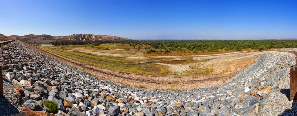

Image: Dan Hale
This photograph above is of Prado Basin Dam and time of year here would be summertime when the rainy season's Spring runoff is at it's lowest and the riparian woodlands at their greenest and most spectacular in appearance. The Chino Hills and Hwy 71 are in the distance to the north and west of this earthen dam water holding basin. I've often stopped along that Highway 71 in summertime to take in the views. In many ways it looks almost like a section of Amazon Rainforests, or at least as I've imagined they would look if I were there. It's one of the rarest pieces of large riparian habitat anywhere in Southern California. But it makes a great illustration.


Photo: M. Dolly
Juan Bautista de Anza (March 18 1776)
"After this the canyon [present day Bautista Canyon], which we followed to the north and north-northwest, kept getting wider and wider [later journal by Pedro Font described this as a Bajada that divided into 2 stream courses and disappeared into the sand], until we reached a broad and most beautiful valley, six leagues distant from the place whence we had set out." 
 Reference of Term "League" - about almost 3 miles
"Through this beautiful valley, to which we gave the name of San José, [San Jacinto Valley] runs a good-sized river, on whose banks are large, shady groves. Likewise in the mountains where the river forms there are seen pines, oaks, and various other trees. All its plain is full of flowers, fertile pastures, and other vegetation, useful for the raising of cattle, of which species as many as one might wish could be raised. And in the same way one could raise good crops, which I judge would be produced with great advantage, . . " 
The photograph above could well illustrate the similar scene of the San Jacinto River flood plain the Spanish explorer's experienced while standing on Park Hill facing north towards the present city site of San Jacinto which would be underneath the beautifully lush riparian ecosystem below the foot of North Mountain (represented by the Chino Hills) or even the Badland Hills further west at the eastern end of Moreno Valley. This actual photo above however is in the middle of the Prado Wetlands area viewing from east to west with the Chino Hills & Corona Freeway (Hwy 71) in the background of this location. Once again, this is only an illustration, but along with the lushness of the riparian forested valley floor, the steep slopes on the other side (imagine they are North Mountain) would have been solid orange with a mass display of California Poppies in full bloom. While those Chino Hills here are of dry grasses, they nevertheless beautifully illustrate the possibilities of what scenery the men experienced when passing through the San Jacinto River Valley floodplains. Especially so nearer to Mystic Lake and Lakeview which would contain a mosaic of small lakes, ponds, lagoons and other backwater marshlands too waterlogged for trees, with the exception of a few Willow and Cottonwood groves on the outer perimeters.

Photo: M. Dolly
Finally, after passing through Bautista Canyon by way of Park Hill by present-day Valle Vista in the east, then stopping at around 4:30 in the afternoon and settling on the banks of  the San Jacinto River near the confluence of Bautista Creek where it enters near the present-day community of San Jacinto , Fray Pedro Font had this observation to make note of to readers:
Fray Pedro Font, March 13, 1776
"After about four leagues the canyon [present day Bautista Canyon] becomes wider and the water of the arroyo, which at the end divides into two branches to open out into the Valley of San Joseph, is lost in the sand."
This is interesting description here of the riparian habitat emerging from the mouth of boulder strewn Bautista Canyon onto an alluvial fan or Bajada. Such geological features can allow for a river or stream to oscillate it's channel course direction back and forth where ever the flood waters during rainy season push it. Log jams and other debris may also have dictated just where and how the course of such a hydrological feature may have move around. Dividing into two channels certainly would have cut water resources in half causing the stream flow to disappear underground just as Font recorded it in his personal journal. The oldest known course is still in existence along Hwy 74 (Florida Avenue), but the other may have angled in a more westerly direction along Stetson Avenue on the east side of the city of Hemet and then being forced to turn northwest by a low boulder outcropping line or chain of hills which block access to south Hemet along western Statson Ave. (READ LINK I POSTED ABOVE) Whatever the case, it's nevertheless interesting that only Fray Pedro Font is the one who noted this geographical and important natural feature of the riverbed.
“In the morning the weather was fair and not so cold, and I was very well pleased by the crystalline and beautiful water of  the Arroyo de San Joseph [San Jacinto River], which runs from the Sierra Nevada [San Jacinto Mountains] and comes through a valley so leafy that because of its beauty and attractiveness we called it Paradise Valley. [Hemet & San Jacinto Valley]
“The arroyo has on its banks thick groves of cottonwoods until it is lost in a large lake which is formed in the valley”
The area of the San Jacinto River and the mouth of the Bautista Canyon Creek is granite boulder strewn, although Agricultural interests have removed these over decades for ease of grove management operations and other cropland farming. But the scene of the two water courses where they came together at their confluence centuries ago must have indeed had granite boulders with pools of crystal clear water in them as the scene below behind upper portions of Prado river Flood Basin have as well.

Photo: M. Dolly

Priest Francisco Garcès (March 18 1776)
"Going seven leagues to the northwest, we came to the beautiful valley of San Joseph [San Jacinto Valley], which has all the qualities for a good settlement. There is a great abundance of good quelites which the Indians eat in season, sour cane which they call sotole, and a little palm which bears dates which are not like those of Spain, but very different. These are found also in Pimería Alta. [Pima region of Arizona] There is a large cottonwood grove, a very large marsh with much pasturage, a lake, and a river which probably is permanent. We saw a countless multitude of white geese like those which I saw at Agua Amarilla"
 
Image by Bert Wildon of Las Pilitas Nursery

This still blows me away. Garcès is the only one who mentions the presence of Dates from the California Fan Palm which actually is native here in San Jacinto Valley near Soboba Hot Springs. Can you imagine California Fan Palms in this abundantly wet landscape filled with a mix of Fremont Cottonwoods and California Sycamores here and there ? Birds, animals and the local Luiseño Indians would have dispersed them in varying locations as they moved through these lush riparian woodlands either intentionally or accidentally. Somewhere somehow several seeds would have had opportunity to germinate in the permanently moist habitat rich pristine riparian habitat. 

Image: M. Dolly

Priest Francisco Garcès (March 19 1774)
"Winding around by a very miry road, we came to a hill, [Footnote 93] having traveled about four and a half leagues almost to the northwest but with many windings, because the hills as well as the plains are so boggy. The groves are thickly grown with grass, one species of which bears a seed very much like rye. 
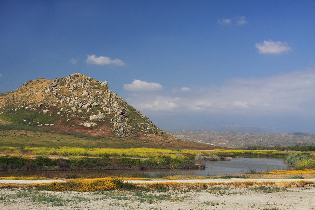

This is the day the expedition moves from the major portion of the San Jacino River valley onto the western plains towards Lakeview. This would most likely be the easiest point of crossing as the picture above could illustrate. The mention of those Hills which would be near Mystic Lake and numerous other Lakes and Ponds are on the western side of the main lake and lesser shallow lakes. It has been assumed from this description that it was on the western side of Mystic and at the foot of this Hill and the ones behind it where they made an encampment before heading down towards present day city of Riverside via Moreno Valley.

Image: (Gregg Koep)
Black Bear is sharpening claws on Black Cottonwood  
"The groves are thickly grown with grass, one species of which bears a seed very much like rye. I have no doubt this is the grain which the Gileños call wheat, for they told me that near the sea there was wheat which they harvested without planting it. Throughout all these lands there are bears, rosemary, sage better than that of Gluadalaxara, cobenas, and chia." 
Priest Francisco Garcès Personal Journal 1774 experdition
Garcès is the only one to my knowledge who makes any reference to bears from this part of expedition in the San Jacinto Valley and clearly it would make logical sense for wintering bears to find greater food sources than the snow covered mountains higher in elevation above. He & Anza both make a later reference to Bears near the area of San Dimas and Ontario California. Can you just imagine coming across the large territorial signs of Bear territorial claw markings on a giant Cottonwood tree in the San Jacinto Valley in a riparian woodland where we no longer find them today ? Almost makes me sick to my stomach to have to write this admission of what humans have done since. Surely the California Grizzly was here in the San Jacinto Valley as well. Below are the references a couple days later by Anza and Garcès of numerous Bears in the valley plains between Ontario California and the mountain foothills.
Juan Bautista de Anza (March 21 1774)
"Having taken over our train by the little bridge, at half past eight in the morning we set forth west-northwest, over good country covered with pasturage, the Sierra Nevada continuing on our right. After going about seven leagues we halted for the night at a fertile arroyo which came from this sierra, and was thickly grown with cottonwoods, willows and sycamores. It was given the name of Los Osos, because of several bear which were seen here and then ran away."
Garcès(March 21 1774)  
"Here there are many bears and sycamores."

Image M. Dolly


Image: M. Dolly
The above images that I have used to illustrate just what the early historical San Jacinto River valley once looked like are from the Prado Flood Basin wetlands area behind Prado Dam in western Riverside County California. The photographs themselves were taken by a young lady who lives in northern San Diego county California who has a flicker photo album and goes by the handle, Mechanoid Dolly. She and friends are apparently avid nature enthusiasts who have a passion for many such wildland areas. You may follow this particular album and others from the link below:
https://www.flickr.com/photos/mechanoid_dolly/sets/
Now for those of you (if you've even had the energy & patience to read this far) who may insist &/or criticize my description of the San Jacinto River Valley as a wishful over exaggeration or perhaps an embellishment of facts and private emotional interpretation of what was recorded in those expedition journals, then think again. All I did was provide a reverse description of what Juan Bautista de Anza himself wrote in his journal where HE actually actually was the one who made a comparison of the Santa Ana River as being similar to what he saw and experience in the valley of San Josè or San Jacinto River Valley. Clearly, the vast Prado Wetlands did not exist as extensively as it does now. The Prado Dam wasn't there to create the backwater environment which exists now, but guess what ? The San Jacinto River Valley has a better natural potential for just such a scenario for no other reason than it's basic flat spread out valley geography. While it has been more channel in modern times, historically the flow would not only meandered slowly forward as a result of heavy lush woodlands, but also sideways for no other reasons than it's extreme flatness of the geography of both the San Jacinto & Hemet valleys. Hence the once extreme presence of vernal pools to the south and west. Over thousands of years the potential for a massive riparian forested system including the existence of numerous backwater lagoons and other marshes on both sides of the heavily forested main river channel would have been a self-sustaining one even when there were normal periods of drought. The potential for washouts and channeling would have been kepted in check by it's own living environment. Only fine silty nutrient rich sediments which have continually built up over countless throusands of years. But rather than trying to convince anyone on this comparative description, read what Anza himself said:
Juan Bautista de Anza, (March 20, 1774)
"At half past eight in the morning we set forth, going northwest for five leagues, keeping on our right a high, snow covered mountain, which drains into the lake mentioned [Mystic Lake]. Having gone two more leagues to the west-northwest [thru Box Springs Canyon], we came to a valley similar to that of San José [San Jacinto Valley], which likewise has a good river, to which was given the name of Santa Anna [Santa Ana River near Mt Rubidoux]
~~~~~~~~~~~~~~~~~~~~~~~~~~~~~~~ 
Here is a link from the rcflood.org website I mentioned above. Great photos and history of that event.
Press Enterprise: "The Floods of February in Riverside County 1980


Tuesday, April 29, 2014

The Vernal Pools of South and Western Hemet (Anza Expedition extra)

Winchester History: Newport Rd before Diamond Valley Lake
When I first moved to western Riverside County back in 1981, it was a world away from where I came from. Still extremely wild and where populated very rural feel about it. After 20 years of living there I never ever thought I'd move back to San Diego County where I grew up. But I did for 5 years prior to moving over here to Sweden which is even more mind blowing in visualizing where you'll end up later in life. I moved up to Idyllwild, but still worked in San Diego County, so I commuted through Hemet to Temecula via Winchester on Hwy 79. Almost all side roads off Winchester Road looked like the one about, the majority of which now is buried under the water of Diamond Valley Reservoir. The countryside was mostly wild nature to grazed ranch land. Temecula was mostly still old town with it's upstart competitor on the opposite side of Hwy 395 (now I-15) called Rancho California which was nothing more than a shopping center with a couple of small housing tracts. An interesting natural geological feature about this part of western Riverside landscape is it's flatness. This makes for prime Vernal Pool creation and unique ecosystem development over time. Unfortunately Vernal Pools are probably one of the least understood and most likely under appreciated type wetlands in the west. The reason is of course for this is that most of the flatland the occupy is generally targeted by some commercial developer's pet project. I mean let's face it, there are no trees of worthy note and the land generally looks waste most times of the year from most human observer's point of view. So why not ?

Photo by Mike Wilson

Warren Road in western Hemet & San Jacinto Valley

This is Warren Road on the very western border edge of Hemet Valley and the lake with the small mobile trailers around it is the recreational facility of Reflection Lake. The worst flooding I have ever seen here in the early 1980s was almost complete and close Warren and other roads for a few months into early summer. I saw water inundating this area of west Hemet Valley so badly that flloding was almost complete from the Ramona Expressway to the north of this photo all the way to Winchester areas to the south of this same photo. Follow the line I photos by scrolling down here. Anza and the other journal recorders were not in any way exaggerating when they spoke of the mucky miry conditions in which they had to travel through this valley. Flooding would have been more complete on the 2nd expedition which took place in January 1776, but in 1775 on the second journey through the end of March when they came through this area would have revealed a much deeper wildflower display. The journals and/or diaries kept by these men at least through this point on the map here was dead on accurate. Take note of the milk dairy farm on the right hand side and the transformation below ?

Farm Scenes with San Jacinto Mtns in background

This photo here is taken on the hills west of Warren Road called Juniper Flats and the same location as the famous petroglyphs known as Maze Stone. Notice the same Milk Cow Dairy Farm shown in the photograph above here where Reflection Lake campground and picnic area is located on Warren between Cottonwood Ave and W. Esplanade Ave. This region always floods big time, but when the waters recede, the entire area is wildflowers if not plowed under by farmers. Unfortunately now this region is becoming housing tracts and concrete lined flood control channels are being constructed to never allow water to form the Vernal Pools ever again. Below is a picture of hills. These hills are between the scenery just viewed around reflection Lake and Hwy 74 to the south. Those two large drinking water storage tanks were constructed before I left for the housing boom which is infiltrating this western Hemet location.

Image: Google Earth

This is western Hemet on Florida Avenue (Hwy 74) west of Warren Road and the Hemet Auto Mall. This is what this area now normally looks like. It is now plowed and usually planted with a winter wheat crop by farmers. Take special note of the small Hills in the background and the two water tanks in the saddle. These type of hills with saddle backs or singles are common on these flat valley floors around here. Fray Pedro Font did describe many of these surrounding hills. Notice the historical contrast some years back when the area was allowed to be more wild with the Vernal Pool formation below. 

photo by Richard Cummins 

West Hemet Valley on Hwy 74 looking north towards the San Bernardino Mountains above Beaumont & Banning
 in the background & Warren Rd at the foot of those small hills north of the Hemet Auto Mall which would be out of photo  on the left side. Every winter this would be a lake and every Spring it would always turn into Goldfield Wildflowers. This would be also repeated on the south side of Hwy 74 all the way to Winchester California. Again, when it rains here there is very little place for water to go. This particular picture above was of flooding here in February 2005, nothing compared to what is was in the early 1980s. 
When I went through here during the big flood events of that time, it was one solid shallow lake which even crossed Hwy 74 which sometimes had to be closed until it could drain off. From Hwy 74 to Winchester is was one large mosaic pattern of meandering lakes which slowly drained westward or not at all. As the lakes or pools dried, masses of wildflowers like Goldfields would replace where the water once stood just like the lake on Cahuilla Indian Reservation. I use to drive west on the dirt road part of Stetson Avenue from it's Jct at Warren Rd west of Hemet Ryan Airport. Driving the back way towards Winchester and I'd park the car along the roadside near the west irrigation canal which ran south to Lake Skinner. The photo above is not an enhanced exaggeration. It is so blindingly bright that you actually did need sunglasses to take in the view. The powerful fragrance in the air around there was always that of the intense fragrance of Honey. 


Image: Google Earth

The photograph image above from Google Earth is a complete turn around from the above Google Earth image on the same Hwy 74 in west Hemet Valley looking north. This is now looking in a southerly direction from Hwy 74 southwest towards the slow water movement flow direction towards Winchester, Menifee and points west beyond. Notice that hill which is scarred by the bulldozed track road leading to the top of that small hill on the upper right here in the photo ? I remember when the guy who owns this did that. It seems like every land owner in Southern California who owns a piece of acreage with a potential view for dream home or future resale speculation has got to play Joe Six-Pack and carve his or her initials into the landscape leaving a permanent scar. Yes I know it's not my land, but look at what this area used to look like before Farmers bulldozed drainage canals and plowed the wildscape from the photograph below. Yes I know, the farmer has rights too !! Below that photo I have copied what was said about this very site by the EPA on the subject of Hwy 79 realignment.

Image: EPA

http://www.epa.gov/region9/annualreport/10/communities.html#intro


"In another case in the Southern California city of Hemet, the Federal Highway Administration, Caltrans, and Riverside County Transportation Commission (RCTC) proposed a new alignment for State Route 79 that would have impacted a 1,000-acre alkali vernal pool complex. EPA’s extensive early interagency coordination on this project focused on the need to avoid impacts to vernal pools. In response, Hemet’s city government updated their general plan to remove this alignment as the locally preferred alternative, and the draft EIS will no longer include this alignment. EPA’s coordination on this project prior to the release of the draft EIS led to avoidance of the vernal pool complex."

Image: Google Earth

Looking directly west on Warren Road across from the entrance to the Hemet Auto Mall

I believe the original alignment through Hemet Valley called for a four lane highway which would run along side the existing concrete lined California Aqueduct canal which does go through the middle of this region from Gilman Springs to Diamond, Skinner and Vail lakes if I remember correctly. I remember all this so clearly because at the time I worked at Jack Gosch Ford & Hemet Toyota which were two of my clients with my auto restoration work back around early 1990s. I remember the smart alecky snarky comments from many of the Car Salesmen & women because of the controversy of saving that landscape across from the Auto Mall. 


Map Animation by Federal Register


Endangered and Threatened Wildlife and Plants; Proposed Revised Critical Habitat for Navarretia fossalis (Spreading Navarretia)

Image:Wiki

 Vernalpool Pincushionplant Navarretia fossalis
The map of course is the area in question north and south of Hwy 74 (Florida Ave) in west Hemet California. The preservation of the area was fought for the saving of a mostly tiny mostly obscure plant that most people have never heard of and/or for that matter could care less about even when they see it. This was the point of criticism by the Car salesmen at the Hemet Auto Mall and other Hemet Business interests who were mostly pro-unrestricted growth back in the late 1980s. Oddly enough the beautiful flowers were never really a major part of that fight because it could be argued that they are so common everywhere in other valleys and most of the hillsides of SoCal. This is true. But what is in danger is the massive display which boggles the mind and inspires awe in people. Antelope Valley for example wouldn't have had a chance were it not for it's remote location. Flat Valleys within the sphere of industrial commercialized Southern California had no such luck as preservation. The photos I have posted here mostly show the common Goldfield Wildflowers, but you should also know that other wildflowers such as the orange  California Poppies and especially the Purple Owl's Clover which would be present in a mosaic of very large patches here and there among the Goldfields. The poppies however were mostly on surrounding hillsides and other low knolls or hillocks. Below is an aerial picture of this same region I've just described above. You will be able to clearly see the small group of hills north of Hwy 74 with water tanks at the upper left with Hemet Auto mall and Hemet-Ryan Airport below that.   


Image by West Coast Sharon on Panoramio

This zoom feature is amazing and fun. You can zoom in an grasp a closer look at this area I have been describing. The actual zoom in and out controls will be in the upper left hand corner of the linked image on Sharon's Panoramio page. In your mind's eye, eliminate all the human infrastructure like roads, canals, railroad right-of-ways, housing and industrial tracts. Add in their place a large mosaic of Vernal Pools and other seasonal shallow lakes everywhere as far as you can visualize on that valley floor. with extremely slow meandering various branches of streams snaking in and out of pools here and there. In between these pools add in all the flower bright yellow colours as a mass carpet, don't be frugal and hold back thinking you'd be exaggerating the scene. Don't forget the great variety either of other flowers colours like the
purple of Owl's Clover. To the north at the San Jacinto River Valley add in old growth riparian forests mostly dominated by the large mushrooming heads of Cottonwoods stretching from east to west or left to right as dense as anything you've seen along the Corona Freeway Hwy 74 as you pass the Prado Basin Wetlands Preserve. Those line of hills on the north side of the SJ Valley called North Mountains, paint them completely orange as they would appear during heavy year's rainy season with California Poppies. All long time residents there know exactly what I'm talking about. Here and there with other parts of the landscape fill it in with the lush green colour as is normal for this area in Spring Time. 

Image: City of Hemet

Instead of this sign above, it could have read something like this, "Welcome to Anza Expedition's World". There are many such great expansive wild regions that still exist on the Earth with such grasslands, streams and pools on Earth as described by Anza and other expeditionary members, but they are mostly found in remote inhospitable areas like Arctic Circle or Mongolia. Such places have no real human economic value and the majority of humankind find those climates undesirable. The San Jacinto and Hemet Valley's only curse is it's geographical location in the pathway of so-called human progress. Still, people should take special note that this area wasn't always a desert-like hot dry dusty environment. Present generations truly have no clue as to what once was. So-Cal's deforestation and general vegetation removal for progress changed all those climatic moderating mechanisms which made possible the landscape which no longer exists. The San Jacinto, Hemet and Winchester Valley vernal pool sites do not have the notoriety of other well known sexy celebrated sites such as the Santa Rosa Plateau or the Miramar Mesa locations where Burrowing Owls are being used to save such seemingly dull & mundane locations which the general public views as nothing more than worthless vacant lots which impede economic progress. Despite being mostly dry at times, once filled with water, these vernal pools teem with life. Much like the dry dull dark gray brown Mosses on granite boulders which spring to life at the presence of moisture. Anza and his party only saw the incredible raw expansive beauty of the wildflowers everywhere they looked. Modern Science has reveal far deeper riches and details about such sites, and yet with such increase of knowledge and deeper appreciation of our truly rich natural world, this hasn't meant a thing to the majority of humankind with the exception of a handful of people. I dare say if humans don't get a handle on this climate change issue, the disappearance of Vernal Pools will be the least of their worries.
Update April 30 2014 after publishing a couple hours ago:
If anyone is disinterested in Vernal Pools, then please don't follow this post. I did not write this for self interest, phishing, spam purposes nor did I plagiarize anything, these are strictly my own comments and observations as I observed them after originally reading these Spanish Explorer Journals back in 1981. I am disinterested in the present petty jealousies, childish squabblings & generally ideologically infected controversies which plague our world today. I would never have even shared my thoughts and opinions in the first place to anyone on this subject had I not moved to such a miserably cold wet climate such as Scandinavian which for the most part has kept me indoors. 

Much of the so-called scientific studies commercial developers pay for I find to be greatly lacking anyway and the end research provided to be tainted & coloured by those who provided the funds for such in the first place. Most environmental impact studies prior to approvals for a development, especially where Vernal Pools are located may never even be conducted during important rainy periods of any given year. This creates a loss forever. There are other related ecosystems in southern California which are generally never discussed and/or associated with Vernal Pools and those are the hanging Garden ecosystems found in various dry washes at the base of chaparral mountains where the water course may undercut a bank and create a type of grotto which slowly bleeds water over a period of months after a heavy wet season. Most folks have zero clue or idea that the very same plant inhabit these grotto walls within some canyons.  One such grotto canyon was on Rattlesnake Mountains near the valley floor where rainy season moisture seeped for months after winter rains. The study was done in summer and nothing found, no kidding! The region is buried now by tons of fill and housing now exists where once a natural unique feature once existed. 

Again, if you dislike the subject here, please don't read and especially don't comment.

Thanks