
Maybe the title should have been - "Climate's Ancient Past, but recent Demise". Scientific myths abound as to what once was in the southwest's moister climate history which helped establish and maintain far more extensive forests than at present. We are told that forest cover was far greater than today in California, but that was 1000s of years ago. Part of learning & extrapolating the truth of a matter can be found by looking up old archive references and reading historical diaries and other official accounts from the recent past. Much of the problem is we don't have many photographs documenting things we'd truly love to know and understand about Nature. People from a couple hundred years ago are long gone and their memories and valuable experiences are long gone. Without them we are left to the biased speculative assumptions which motivate researchers today. (Including me I suppose) For me, even if I appreciate a written paper, I've just got to verify it for myself, know what I mean ? Pouring over such old documents and even gleaning clues from literature which was never intended to be written from a Naturalist perspective still can reveal important informational clues.
(read about the importance of archives and older folks experiences)
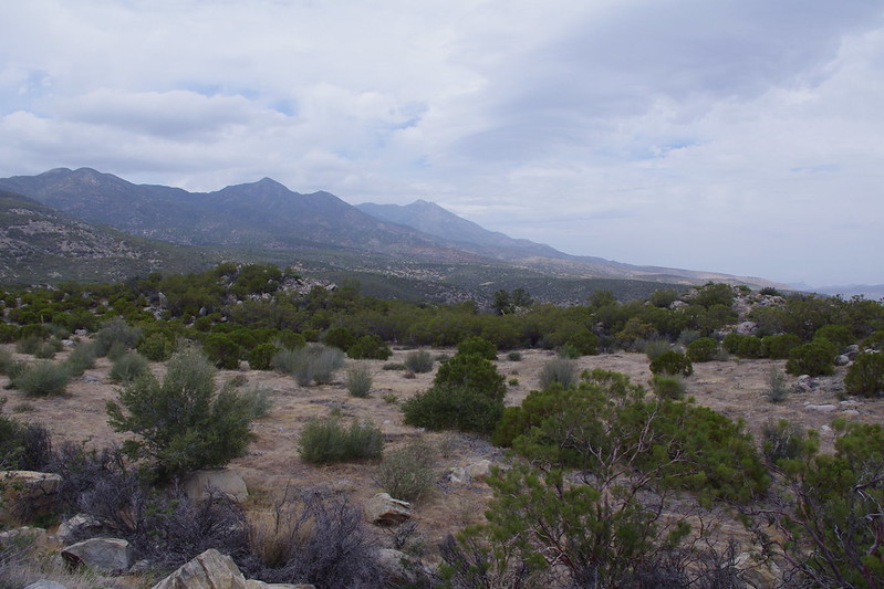
First off, I have to admit, I this fascination [okay obsession] with the past climate influence of the area's Ancient Lake Cahuilla which was located directly to the east and south of this mountain range and what caused it's decline. Then there there is the recent research material released this past year of two different volcanoes ( Salton Buttes & Sunset Crater - AZ) erupting very closing during this same time period in the southwest and the same uncanny decline of the Ancient Anasazi civilization almost simultaneously ? Seriously, all these events [volcanic eruptions (earthquakes?), Lake Cahuilla's decline, Anazasi decline as result of environmental change] happen in close time frame proximity with one another in the southwest. Hmmmmm, this is where I've always wondered if there could possibly be any unusual plant anomalies held over from the change to provide any clues to a wetter climate's historical past ? Well maybe. I have yet another post on possibilities of ancient Lake Cahuilla's influence on climate and vegetation in the next month or so. Keep a watch out for it. But for now, I actually have two examples of plants that I found fascinating years ago. It was actually back in the early 1980s, but I never before gave a thought to document them as I had no interest in proving anything to anyone else but myself. What a mistake that was. I wish I had documented more. Sad how things change so rapidly in a downhill fashion in our modern times, especially when it comes to the Natural World. Anyway, take a look at two important examples I have now documented on my 2013 trip back to the USA.
 |
| Photo credit: Mine! |
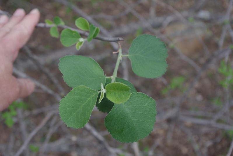
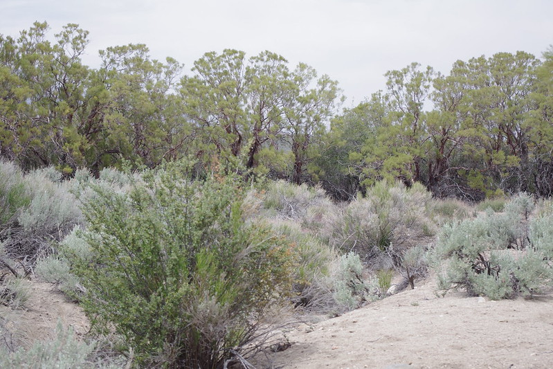
I know, it's not much to look at, but this small tree wasn't always like this. It was always heavily adorned with green delicate looking foliage which would loose it's leaves in the Autumn. Flowers were five separate distinct white petals, and a small green to purple fruit at the end of the season. This particular remnant of a tree is perhaps an indication of a once wetter moister climate is listed as,
Utah Serviceberry (Amelanchier utahensis)
Thanks to Tom Chester for the official identification
 |
| photo - Sally & Andy Wasowski |
For my first few years living on Table Mountain in Anza just above where this tree is located in the watershed of Hamilton Creek in Burnt Valley. Truthfully I never noticed it before as it must have simply blended in with the surrounding chaparral plant community. That is UNTIL one Spring during those heavy rainfall Winter periods in the early 1980s, I saw the most spectacular white blooms on this small tree which were gorgeous in their mass display. The photo to the right here shows an example of such spectacular flower display potential in wetter times. Unfortunately, this present 2013 drought in Anza CA would not produce anything. But this year in 1984 I stop and got a closer look. How could I not. The scene stood out in stark contrast to the surrounding vegetation. It was just of course unusual because it didn't seem to fit the surrounding profile of the other trees and the chaparral. After all, the Anza region was normally a very dry summer hot and dry winter cold area and I thought, 'how could such a plant be so out of place' ? But it was just a few feet from the creek which no doubt was an advantage. The only other place I had later ever seen this small tree was in the North Fork of the San Jacinto River watershed just to the west of the Hwy 243 north of Pine Cove / Idyllwild regions. Interestingly, those particular Utah Serviceberry specimens were inside an old growth forest setting where it was darker and far more moister than the Burnt Valley location. That was the start of my thinking about a different type of climate that may well have existed way back when. I tried like crazy to find another example of this plant all through this watershed and have never ever found a single one other than this one and it's barely hanging on. This is it. Clearly it's seed came from somewhere, just like the Seed source for the small colony of Lemonade Berry on Rattlesnake Mountain. Odd plant puzzles like this should challenge all people to investigate and learn more about the environment around them. At the very least it keeps hikes interesting if you challenge yourself to set out to specifically explore and find newer treasures. Not everything in the nature has been found, discovered or becomes known to mankind, despite what this world's leadership may want you to believe. To this very day, I have never found another single tree of this species in this region, but that doesn't mean there is none. The hills, canyons and dry washes above and around this tree are also littered with 100s of mummified remains of both Coulter Pine and Jeffrey Pine logs, with only a few living stunted remnants to give any clues of a different climate past. I also found some mummified remains of some small Incense cedar, but that remains to be photographed if I can find them again. I also need permission from Agri-Empire to go back onto their land to investigate. When I found those, I brought it to the attention of Wildlife Biologist Tom Roberts up in Idyllwild back in 1983, but he wasn't overly interested back then. Understandable since he was fighting further development up in Garner Valley at the time. Even still, the presence of Incense Cedar would definitely speak of a time when conditions in this particular area were wetter. This was also the same time period when another single specimen plant anomaly got me thinking about a wetter climate past. Believe it or not, it was a single Jeffrey Pine (Pinus jeffreyi) on Hwy 74 along the Santa Rosa Mountain section of the highway that made me begin to wonder again, but more on that at the end here. First, here are some closer shots of the Utah Serviceberry which although looking dead, is struggling to come back by way of three or four healthy suckers from it's large trunk base.
 |
| Photo Credit: Mine! |
Utah Serviceberry (Amelanchier utahensis)
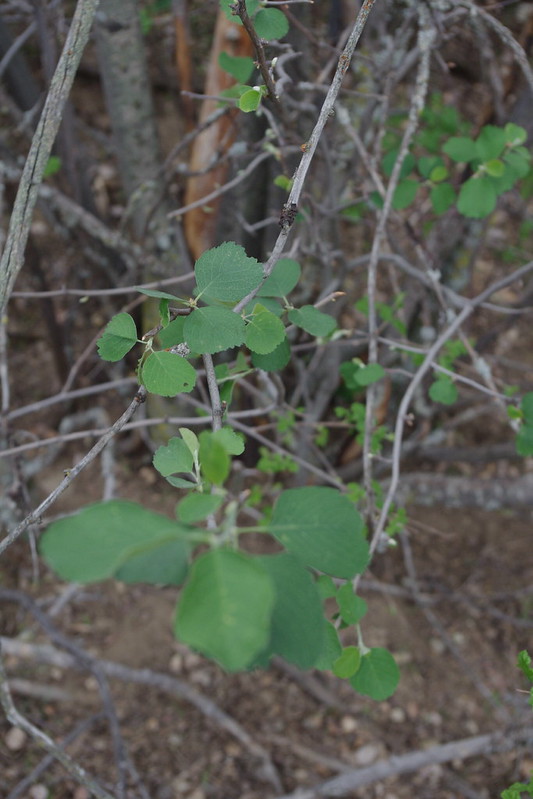
This is a close up shot where I had to pull up from the base some of the newer growth struggling to come back again. I was shocked and disappointed to see this tree mostly dead until on closer inspection saw that it was still clinging to life through the growth of a few suckers from it's root stock base.
 |
| Photo Credit: Mine! |
Pale leaved serviceberry, Service Berry, Utah Service Berry, Western Serviceberry
Again, another shot of the growth trying to make a come back from a different location at the trunk base. Here is a bit more info and highlights of this rare plant of the San Jacinto Mountains.
 |
| Photo Credit: Mine! |
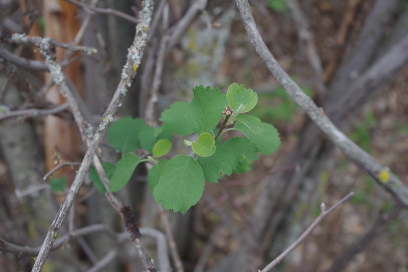
Once again, this is simply another shot of a different sucker to the left off the main trunk at the base. This small tree was always multitrunk and beautiful in appearance. It's just a shame the conditions lately have deteriorated so much that not only this plant, but many others are having a rough go of it.
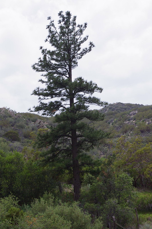
Now there was another plant anomaly which always gave me pause when I passed by it while regularly traveling on Hwy 74 when commuting to work in the Coachella Valley in the deserts below from my home in the high mountain valley of Anza California. This singular Jeffrey Pine (Pinus jeffreyi) is located on the very eastern border of Santa Rosa Indian Reservation along route Highway 74 in the San Jacinto Mountains. When I see such lone plant anomalies, I stop and take pause wondering where did the parent seed come from. Of course, perhaps someone planted it along the highway, but this was actually not the case. For whatever reason either the CalTrans or other individuals (perhaps Forest Service) have periodically cleared the chaparral from around this tree as the photo will indicate if you do a surrounding chaparral plant community comparison. One day with time on my hands I finally stopped and decided to investigate much deeper. Another reason is that I saw another pine further on down the dry wash or Arroyo in the direction of Palm Canyon watershed. That particular tree was very much struggling for it's life. It only had needles from the previous year's before growth along the whorls of it's branches. Most healthy Pines of any variety will have six or seven years growth of pine needles still clinging to the branch growth whorls from each previous year's growth cycle. This tree is now presently gone for good and actually fallen over as the photo below will reveal. It was associated with an Interior Live Oak (Quercus wislizenii) which still appears to be healthy. You can see into the Oak tree's interior main trunk which is visible because of the competitive growth with the Jeffrey Pine once on it's north side.
 |
Photo Credit: Mine!
Jeffrey Pine (Pinus jeffreyi) |
This is looking west on Highway 74 with the pine to the left, and no doubt ignored and never given a second thought by passers by. On closer inspection if you drive by slowly, you'll see cut chaparral meant I guess as a fire break measure to protect this tree.
 |
| Photo Credit: Mine! |
Here is a much closer shot of the Jeffrey Pine. The foliage on this particular tree has always been healthy and I have collect cones for seed from it in the past for germination.
 |
| Photo Credit: Mine! |
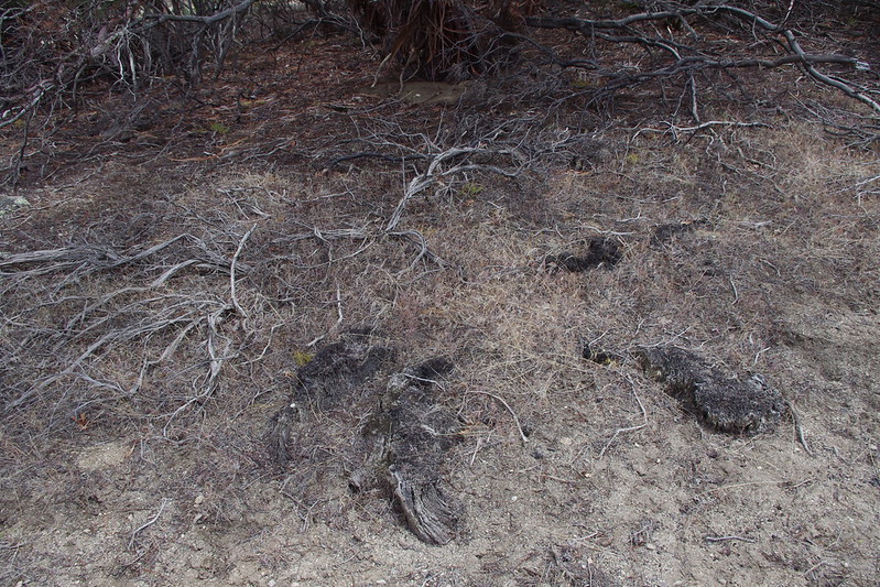
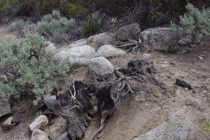
This is an area just east of the Jeffrey Pine along Hwy 74 looking northwards towards Palm Canyon which opens out into Palm Springs. These geologic features of granite boulder outcroppings divided by various elevations of steppes or dry bunch grass meadows (many are loaded with native bunch Grasses) are where most of the fire charred stumps are to be found. In the past I have found large charred stumps a couple feet in height in some of the granite outcrops, but most are within the flat steppes. There is a steppe below this one where I bushwacked and photographed the following Jeffrey Pine charred stump anomalies for which you will find no mention anywhere in any historical literature.
 |
| Photo Credit: Mine! |
This is the third steppe down from the roadway where I took the photo of the Steppe near the road above this one. This is where most of the stumps I've photographed are to be found. I had no more time to bushwhack and photograph others as my brother was waiting for me in the Jeep parked along the Hwy 74 where pullouts are few to be found. I was gone for almost an hour and had to turn back again. Still these stumps were both thrilling and sad again to see & imagine what once was.
 |
| Photo Credit: Mine! |
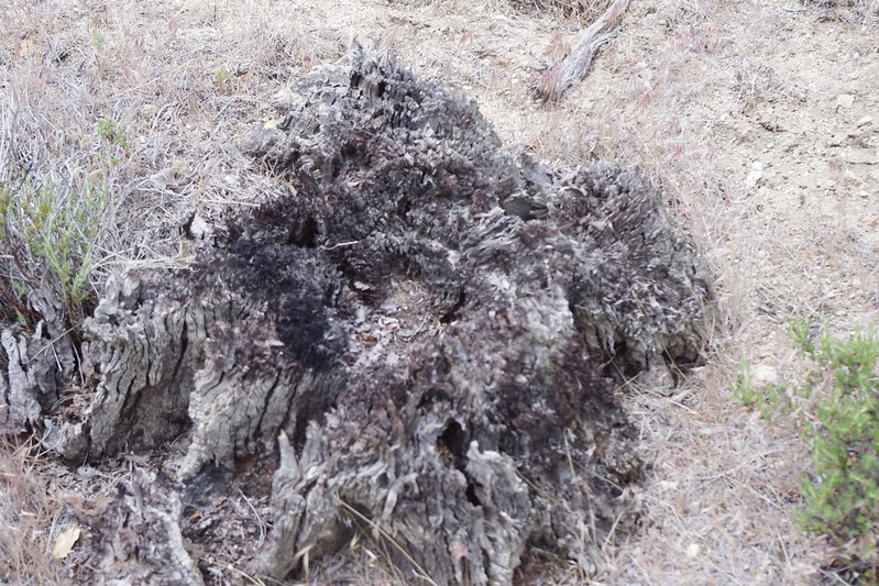
This is the dead Jeffrey Pine carcass fallen away from it's former neighbour the Interior Live Oak (Quercus wislizensii). This tree was seen by me alive back in the very early 1980s before dying finally in the late 1980s and also is located in that meadow or dry steppe pictured above this photo. The next four photos will be a collection of those ancient almost disintegrated charred stumps which will eventually disappear completely in the future.
 |
| Photos Credits: Mine! |
All these stumps were the easiest examples to find. Many others are deep within the old growth Redshank or Ribbonwood (Adenostoma sparsifolium) pictured in the photo which I must say in the second steppe meadow photograph above were giant old growth examples although the photograph may not reveal the true height of these Elfin Forest giants. Though these stumps have deteriorated quite a bit, they nevertheless reveal what once existed and was later destroyed by human carelessness with fire.
Here is a reference from my previous article or post which covered two studies in which the vegetation redistribution was debated by two competing Theorists for lack of better description of their behavior. Here is the link to my previous post on the subject of the fire and vegetation changes on Santa Rosa Mountain and a partial quote about the significance of two very major fires
Santa Rosa Mountains & Climate Change - Will Anyone Pay Attention ?
When I first arrived in Idyllwild, I inquired of the Control Burn Supervisor Steve Raybould and Wildlife Biologist Tom Roberts about what fire deforested the entire north face of Thomas Mountain above Garner Valley. Back when I first arrived in those mountains in 1981, there were still many of the burnt snags and logs that were still visible everywhere on that north face. Presently when passing through the area on Hwy 74 last Sunday, most are gone or hidden by the Chaparral. Both Tom & Steve told me of two major fire events, one around the turn of the Century and another in the 1940s which later finished everything off. The fires came from the direction of Santa Rosa Mountains and they both said it was the Santa Rosa Indians who started them through carelessness. People often love to romanticize the Native Americans as almost being a part of Nature and being one with the land, but the fact is they are not animals, but real human beings just like anyone else with the same failings as other people. I really don't care if the people responsible for those fires were Purple with Green Stripes and Pink Poka dots. The major cause of change in this case was & has always been human and the consequences of these events resulted in certain name changes of specific geographic locations within Anza Valley and the surrounding countryside. Names like "Old forest Road" (where no forest actually exists) and even the name "Burnt Valley" itself truly leaves one to wonder about the why question. I'll deal with these in another future post I already have set aside as a draft. I just need more photos to verify causes of the change as indicated by clues. Anyway, historically the fires were 1922 and later 1947 and they burned big time from the Santa Rosa Mountains to Lake Hemet and through Burnt Valley and the southern face of Thomas Mountain. Whatever was left after the climate change back then was eliminated permanently after both those fires with any come back having great difficulty as I will show. Below is one part of a paragraph from my previous post link above referencing material from one of the researchers who looked for plant growth changes as a result of fires and for which I do agree.
They also followed the same fire history as referenced in the other study which indicates a huge major fire 91 years ago which would put that around 1922 and another major fire around 1947. Sure enough you can check Cal-Forestry historical fire records and the early 1920s and late 1940s had major fires in the Santa Rosa Mtns. Here is a link to this website for fire records: Cal Dept of Forest & Fire
Further Reading on ancient Lake Cahuilla and it's potential for influencing a much wetter milder climate, see the other post from February 11, 2013. Also an associated article regarding San Joaquin Valley from it's Historic past.
What exactly is the weather phenomenon known as the "lake effect"?
AND
What California's San Joaquin Valley Once Was!
Enjoy the Reads if further interested.


No comments:
Post a Comment
Thanks for visiting and stopping by with your comments!
I will try to respond to each comment within a few days, though sometimes I take longer if I'm too busy which appears to be increasing.