Well, I'm learning more and more. Just learning all their tools and other feature has been fun. Take a look at the 'Going back in Time' image feature where you can go back a couple decades. Definitely has been useful to researchers watching the downwards spiral of the Natural World. Check out the link below here where some amazing uses for this imaging through time are exposing the ecological disintegration of some of earth's resources.
Business Insider: "How to Go Back in Time on Google Earth on a Desktop"
 |
| Speed of Creativity |
Here are some photos and images I've played around with. For example, yesterday I wrote about the documentary by CNN on Medical Cannabis. Having lived in Anza where Pot Farms were once common and two of my neighbours arrested for growing Pot for Profit, one of whom lost his entire 10 acre homestead which by Law had to be forfeited to the State, I remembered some remote Pot Farms I stumbled upon in my bushwhacking days. One most notable was found along Strawberry Creek below Idyllwild California and physical effects still visible through Google Earth. Take a look.
 |
| Google Earth |
This is a Satellite view of Strawberry Creek with Route 74 at the bottom and the very west end of the Idyllwild Community at the top. Access is more difficult now, but the Pot Farm scars are still visible if you know where to look along the east side [righthand side] of Strawberry Creek.
 |
| Google Earth |
Incredible isn't it ? Human created scars out in the middle of virtually wilderness. Of course this isn't the only scar on Earth as seen from Satellite in this region. Below Is another shot of the other side of the San Jacinto River which illustrates the damage cause by original Hwy Route 74 paving project and Creek diversion scheme gone terribly wrong. Well, at least from an entire environmental view and Ecological perspective. See image below.
 |
| Google Earth |
This large abnormal scar along the eastern side of the South Fork of the San Jacinto River Canyon was created when a deliberate diversion was made to run the Baldy Mountain Creek due west instead of it natural and historical meandering towards the north. This no doubt saved the State Road department some $$$ by not having to build a bridge over the section for which the road crossed over this Creekbed. In old photos, this was originally a horse and wagon dirt road. No doubt washouts were a major issue which influenced this irresponsible decision. I previously wrote two post on this place with a preview (Here) and the main subject's article (Here).
 |
| Google Earth |
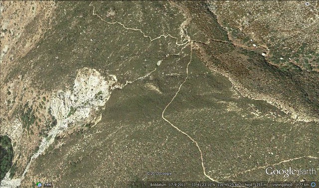
Hamilton Creek Alluvial Floodplain in eastern Anza Valley in California. On August second I posted an article on my experiences on my two decades search looking for clues on this regions once far more extended forested areas as referenced by early pioneer homesteader descendants to the area and as well as comparing accounts from Spanish Explorer Juan Bautista de Anza who also mentioned the mountains very heavily wooded Oak Woodlands and Pine Forests. He also mentioned numerous major springs[ a few of which I know about] in the area which were reported back to him by search parties he sent out. As you can see here, the Hamilton Creek once veered to the right n this Satellite photo, as even evidenced on the ground with those two large Interior Live Oaks on the south side of Hwy 371
San Jacinto Mountains: Moving back thru Time by means of Observation
 |
| Google Earth |
This is down in Nance Canyon just east of Terwilliger Valley and below the San Carlo Pass where Art and Violet Cary once owned and lived at the old Fred Clark Ranch. This is the view at present. If you google map this region and expand or pan around, you'll notice this entire valley has evidence of total past flooding during high wet years. Most new people have no clue to a historical past of a geological location as these people who have stripped the landscape and put animals and several buildings down in this wash. The change seems to have taken place between 2004 - 2005. See below.

Notice the Google Earth Time Travel feature control at the upper left hand corner. The riparian vegetation [which is rare these days] is still present in the wash. When I first came here in 1981, the entire area had numerous mature old growth Cottonwood trees scattered throughout this valley. Now there is barely a handful of any type of riparian habitat left. Oh well, none of my business of course. Just saying!
 |
| Photo image - Rick Halsey |
And finally here is a visual view of an area I came back to where I met Rick Halsey of the California Chaparral Institute and his young colleague Dylan Michael Tweed. We explored that disastrous irresponsible Cal-Fire Control Burn in the San Felipe Valley areas north of Julian and Scissors Crossing inside the regions of the former 2002 Pines Fire which was started by a government agency's Helicopter looking for Pot Farms up near the top of Banner Grade and burned all the way north of Ranchita. This control burn which took place this past Spring 2013, blitzed over the previous wildfire burn of 2002. I also remember while viewing all of this and reminiscing back about the time in history when I use to travel this road back and forth to El Centro from Anza [1980s] and how lush green the entire valley was in Summertime when the Monsoonal season rains started. The hillsides all around the valley were Mesquite trees and Catsclaw Acacia, with the Acacia being the more abundant on the higher slopes. This area looked more like somewhere in Arizona, than California. The best I can do now is tell you all a story like Art & Violet Cary told me about the early days of the 20th Century up in Anza. There is no guarantee anyone will believe me.
 |
| Google Earth (2012) |
Take a look at the scene here with almost everything in a dead state. This isn't dormancy, this is simply the past several years of drought and land mismanagement, along with global mismanagement which has resulted in Climate Change. The very first time I drove to this exact spot in the early 1970s was when I got my Drivers License as a young teen and there were massive riparian forests here, mostly majestic old growth Cottonwoods and Willows everywhere. The creek was full and had a heavy meandering flow, even deep in many spots. There were also fish here, large ones too, which darted when you walked past the stream's edge, although I cannot now identify them. But also mostly those small Top Minnow mosquito fish. I know I can't get anyone to believe me about this, but never the less that is what I experienced. At best all I can do now is tell you a story. If I could have foreseen the future and what was to become of this place, maybe I would have taken actual photographs to back up the story. This large dead Cottonwood Skeleton to the right is actually a relatively new comer and not one of the originals. It's incredible, while it does take thousands of years for a health productive ecosystem to develop on a macro level, it only takes 150 years to screw it up under the excuse of enlightenment and manifest destiny over natural resources. Pathetic when you ponder it really! Below I took some of the photograph series of yearly historical photo shots from the Google Earth "Way-Back-Machine"
 |
| Google Earth - Scissors Crossing (2002) |
 |
| Google Earth - Scissors Crossing (2006) |
 |
| Google Earth - Scissors Crossing (2009) |
 |
| Google Earth - Scissors Crossing (2010) |
 |
| Google Earth - Scissors Crossing (2013) |
The opposite side of the San Felipe Creek bridge also use to contain more old growth Cottonwoods which tapered off until the flood plain became this massive region of lush native Rushes and Sedges. All of that is now gone and the non-native Tamarisk Trees have taken their place. Nothing green really exists here any longer. Everything has changed for the worse now. I have to admit, my trip over there did provide some positive examples of what I wanted to show, but more so I was disappointed at the degradation of all the various plant communities everywhere. Fires most certainly are a major factor, but most are caused by irresponsible Human error. The main thing Google Earth can do is illustrate the past to the present and perhaps in that way could be used as a major research tool. While it can record for you the downward spiral of the nature of things, it can also be utilized as a major research tool for an environmental research projects progress through time. I wish it could go back to the days of the 1800s and further, but that would be the thing Science-Fiction is made of. Still ? *sigh*


No comments:
Post a Comment
Thanks for visiting and stopping by with your comments!
I will try to respond to each comment within a few days, though sometimes I take longer if I'm too busy which appears to be increasing.