 |
| Photo Image by Richard Halsey, Chaparral Institute |
Last year I accompanied Chaparral Biologist Richard Halsey and his assistant Dylan Tweed to inspect the damage done by an un-necessary and costly Cal-Fire control burn which actually got out of control and extended the burn into an already burn recovery area of the 2002 Pines Fire which was started by government helicopter looking for drugs and accidentally hit a power pole. This fire as you may recalled burned all the way from Banner Canyon to the higher elevation community of Ranchita California and northward into the mountains beyond. At one point many thought it would burn all the way to Anza California. In the above picture, Richard has pointed out a location of the eastern most low elevation Engelmann Oak grew, but now are mostly skeleton snags. No doubt if lucky, they will sprout back from the trunk and possibly branches. We reached the point of a hill, but I couldn't go on any longer. The knee I had an operation on was hurting again [exacerbated by bushwhacking just a month earlier up near Idyllwild], so I stayed behind, viewed the entire valley to the south & east and reminisced about what this place use to look like decades before. At time of traveling this valley from the 1960s, 70s & 80s, I never thought to photograph what I always assumed would always be there. The view last year were of mountains on the east side of this San Felipe Valley which were bare and brown. In the old days they were bright rich green, even & especially during the Summertime. The plant community did have large chaparral plant species like Sugarbush and Hollyleaf Cherry, but was mostly dominated by the rich greenness common to Mesquite and Cat's Claw Acacia, with the later being the most dominant by at least 75% of the plant cover. Ocotillos were also on these eastern slopes of the valley. The valley was always a beautiful green until a fire in the late 1980s changed a portion of this. The Rancho Valle de San Felipe at that time was still a working Cattle ranch. San Felipe Road has several Hwy cattle guards which still exist today, but back there there were no fences as cattle were allowed to roam freely. There were attempts back in the late 1980s by the private ranch owner to eliminate all the Mesquite Bosques on not only the valley floor, but also the lower gradual slopes or steppes of those Vallecito Mountains which border on the east of San Felipe Rd. Some clearing was done by fire, and one of these burned on the east side of San Felipe Rd over the those mountains and on down into Sentenac Canyon where a split in the Vallecito Mountains allows San Felipe Creek to flow towards the Salton Sea. They later took bull dozers and scraped piles of dead Mesquite in separate mounds and burned them that way. What I do remember about that first fore was the large black scar in the middle of a sea of bright green. The erroneous idea was that such vegetation removal would allow grasses to grow in place of the Mesquite and Cat's Claw Acacia. Big mistake since cattle love mesquite pods which produce every years and are very high in nutritious proteins. Nevertheless, eventually the entire valley and surrounding mountains have since then been burned off to the point where the rich greenness of the border hillsides have never completely recovered ever again. Eventually the valley floor itself has died back to the point of where only a handful of riparian habitat pockets remain. The former 9,972-acre (40.36 km2) San Felipe Ranch is no longer private ownership, but rather purchased by the government some time back.
On an older Topo Map above are some symbols denoting marshlands otherwise known as Sentenac Cienega which was a rich surface spring region which began at the top of Sentenac Canyon where San Felipe Creek flows east down into the Borrego Desert on it's way to Ocotillo Wells and the Salton Sea. The University of Arizona photo to the right was taken in 2004, but even this picture does not tell the story of how rich green this spring fed wetland actually was. Never were there any brown straw in among pale green. It historically was always deep rich green with no variation in it's greenness. You should also be aware that even the green here above is no longer in existence, but rather brown and dry, with scrubby ragged Tamarisk moving in. This area is just east of Scissors Crossing. You should also take note that most all the large old growth Cottonwoods in Sentenac Canyon are gone as are the spectacular waterfalls which were numerous and ran all year long year after year. Okay, back to last years trip and the changes here since then.
So while playing around with some of the Google Earth features after I came back to Sweden last Spring 2013, I stumbled upon the ability to look back at the same picture historically over a period of years. Hence I looked at the same location at Scissors Crossing and the dramatic degradation of the riparian habitat loss along San Felipe Creek which had traditional always had been a permanent wealth of water flowing all along it's surface. From the Sheriff sub-station at the upper end of S-2 or San Felipe Road, all the way to Scissors Crossing, there was always a large permanent green ribbon of life. Since the early 1990s this area has gone rapidly down hill ecologically speaking. The photo to the right is looking down and east on the San Felipe Valley floor at Scissors Crossing. In the foreground are the skeleton remains of mostly Engelmann & Scrub Oak, Cuyamaca Cypress and Coulter pine which were made such by the 2003 Cedar Fire. I'll provide more on this Inspiration Desert Viewpoint much later in a separate post where I found a treasure trove of PT Mycorrhizae truffles. Below is a 2006 photo of the Scissors Crossing bridge and although there are some green vegetation of Cottonwoods present, the former old growth riparian forests which once flourished are gone as is the surface water stream. Presently today there is nothing but a dry sandy wash which is now converting into a true dry dusty desert floodplain.
 |
| USGS Historical Topographic Map |
 |
| Image University of Arizona (2004) |
 |
| Desert Viewpoint south of Julian on Hwy 79 |
 |
| image: San Diego Birding Pages (2006) |
The photograph here taken in 2006 by the San Diego Birding Society is nothing compared to the majesty that was once this old growth forest where permanent crystal clear surface stream water could always be seen rushing under this bridge on it's way east towards the Salton Sea. While the surface water here in this picture was close to the surface which allowed these trees to exist, there was no surface running water here any longer in the form of it's once historical streambed teaming with lots of aquatic life which now no longer exists.
 |
| Google Earth (2012) |
This photograph taken by the Google Camera Van was taken in 2012. Those same trees from the 2006 photograph are now completely dead in this photograph. In the photos after 2012, even these dead wood skeletons are gone as well. This was the photograph I used last year to verify in my article last summer in 2013: Anyone Really into Using Google Earth ? I hadn't actually gone down to Scissors Crossing last year, but little did I know it was worse than the photo above.
This photograph was taken two weeks ago on June 30th. The Cottonwood trees still standing in the distance are actually only partially leafed out. They are beginning to struggle. As a youth in the early 1970s who started driving, we would stop at this exact spot and go down to the water's edge. You couldn't see much beyond the railing and massive Cottonwoods & Sycamores. Down by the water the first thing you'd see with the masses of tiny fish darting everywhere. Oddly enough these were not the common Mosquito fish (Gambusia), with that characteristic flat topped head and body. Off hand from memory, I would relate what I saw and caught to something similar to the Arroyo Chub (Gila orcuttii) which I have seen in the San Jacinto South Fork River canyon, but perhaps more likely it was something more similar to the down stream Desert Pupfish (Cyprinodon macularius) which is indeed native to the lower San Felipe Creek, Fish Creek and drainage ditches all around Imperial Valley. I use to fish down there in the 1970s canal fishing and some drainage ditches. Young Mexican kids were always catching them back then and using them for bait for catch fish under road culverts. In any event, what were present didn't seem to be mosquitos fish.
Back in the middle 1960s, my friends and I who were on a Boy Scout camping trip at Ocotillo Wells further to the east from Scissors Crossing. But the Scout Master stopped all the vehicles at Scissors Crossing for us to walk around and explore. We indeed did see what were clearly larger fish which would dart here and there sending those smaller fish scurrying for cover, but we could never get a handle on exactly what they were. We had no idea whether someone had let go some bluegill or bass, but they seemed too slender for those fish and the habitat seemed two warm for trout of any type. Pondering back now, I'd love to believe they were historical holdovers from when Lake Cahuilla was at it's shoreline peak near Ocotillo Wells and San Felipe Creek flowed more perennially down to the lake's shore where perhaps some Humpback Suckers and Bonytail Chubs may have made their way upstream. Both of these were present in the Cahuilla Fish traps and hearths around Coachella Valley, but again who really knows for sure.
Another critter we use to see were turtles which would flop back into the water as we walked along San Felipe creek's banks. I have to assume that this could have been the Western Pond Turtle, but again way back in the 1970s. It could also have been the Desert or Sonoran Mud Turtle (Kinosternon sonoriense), since this region has more connection to deserts east, but again, who knows for sure. Not myself, nor friends ever gave it any thought way back when, other than we knew what we saw. The other creature which I don't remember seeing, but know of it's existence is the lowland leopard frog which is endangered and use to inhabit the upper San Felipe Creek all the way to San Sebastian Marsh near the present day Salton Sea.
Whatever the truth about the exact species of critters we saw, they never the less existed and the reason was water, which also now appears to be extinct as well. Recently about 3 or 4 weeks ago, I met Curtis and Linda Croulet up in Anza California at there home in Terwilliger. Curtis actually verified many of the things I saw there as he has worked at conservation in this specific area or region of the San Felipe Valley. If the world doesn't get a handle on this climate issue, many more things are bound to disappear.
This view is looking towards the south side of San Felipe Creek bridge at Scissors Crossing. Straight ahead is community of Shelter Valley and the creek itself veers off to the left down Sentenac Canyon. Between here and the Canyon most of the majestic Cottonwoods are gone and even the Mesquite are struggling against the invasive Tamarisk which was never there previously in such massive population numbers. The lush reeds, rushes and sedges are all but gone now.
 |
| Updated Photo from Google Earth (2013) |
This is the updated version from last year which reveals the dead wood from the trees which was consumed in a fire since then. Definitely in poorer shape, but it gets worse.
 |
| San Felipe Creek bridge on Hwy 78 looking north (June 30, 2014) |
This photograph was taken two weeks ago on June 30th. The Cottonwood trees still standing in the distance are actually only partially leafed out. They are beginning to struggle. As a youth in the early 1970s who started driving, we would stop at this exact spot and go down to the water's edge. You couldn't see much beyond the railing and massive Cottonwoods & Sycamores. Down by the water the first thing you'd see with the masses of tiny fish darting everywhere. Oddly enough these were not the common Mosquito fish (Gambusia), with that characteristic flat topped head and body. Off hand from memory, I would relate what I saw and caught to something similar to the Arroyo Chub (Gila orcuttii) which I have seen in the San Jacinto South Fork River canyon, but perhaps more likely it was something more similar to the down stream Desert Pupfish (Cyprinodon macularius) which is indeed native to the lower San Felipe Creek, Fish Creek and drainage ditches all around Imperial Valley. I use to fish down there in the 1970s canal fishing and some drainage ditches. Young Mexican kids were always catching them back then and using them for bait for catch fish under road culverts. In any event, what were present didn't seem to be mosquitos fish.
 |
| Desert pupfish photo © John Rinne |
Back in the middle 1960s, my friends and I who were on a Boy Scout camping trip at Ocotillo Wells further to the east from Scissors Crossing. But the Scout Master stopped all the vehicles at Scissors Crossing for us to walk around and explore. We indeed did see what were clearly larger fish which would dart here and there sending those smaller fish scurrying for cover, but we could never get a handle on exactly what they were. We had no idea whether someone had let go some bluegill or bass, but they seemed too slender for those fish and the habitat seemed two warm for trout of any type. Pondering back now, I'd love to believe they were historical holdovers from when Lake Cahuilla was at it's shoreline peak near Ocotillo Wells and San Felipe Creek flowed more perennially down to the lake's shore where perhaps some Humpback Suckers and Bonytail Chubs may have made their way upstream. Both of these were present in the Cahuilla Fish traps and hearths around Coachella Valley, but again who really knows for sure.
 |
| Humpback Chub (gila cypha) |
 |
| Bonytail Chub (Gila elegans) |
 |
| Photo by Diego Ortiz Sonoran or Desert Mud Turtle |
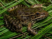
Another critter we use to see were turtles which would flop back into the water as we walked along San Felipe creek's banks. I have to assume that this could have been the Western Pond Turtle, but again way back in the 1970s. It could also have been the Desert or Sonoran Mud Turtle (Kinosternon sonoriense), since this region has more connection to deserts east, but again, who knows for sure. Not myself, nor friends ever gave it any thought way back when, other than we knew what we saw. The other creature which I don't remember seeing, but know of it's existence is the lowland leopard frog which is endangered and use to inhabit the upper San Felipe Creek all the way to San Sebastian Marsh near the present day Salton Sea.
 |
| image: Calphotos Lowland Leopard Frog |
~~~~~~~~~~~~~~~~~~~~~~~~~~~~~~~~~~~~~~~~
 |
| Hwy 78 bridge over San Felipe Creek looking south (June 30, 2014) |
This view is looking towards the south side of San Felipe Creek bridge at Scissors Crossing. Straight ahead is community of Shelter Valley and the creek itself veers off to the left down Sentenac Canyon. Between here and the Canyon most of the majestic Cottonwoods are gone and even the Mesquite are struggling against the invasive Tamarisk which was never there previously in such massive population numbers. The lush reeds, rushes and sedges are all but gone now.
 |
| image: Charles Doersch (April 2012) |
These are some hikers camping under San Felipe Creek bridge in April 2012, something that never would have been before possible just a few decades ago where permanent surface water flowed under here at a good pace.
~~~~~~~~~~~~~~~~~~~~~~~~~~~~~~~~~~~~~~~~
Conclusions
There are multiple complex components all throughout this San Felipe Valley riparian ecosystem & beyond which are only the tip of a vast iceberg here. For that matter, take any ecosystem around the globe and view as a body with various parts of necessary function: climate, geography, plants, animals, birds, reptiles, aquatic creatures, whatever – all of these components within their niche habitats can be subdivided into sub-ecosystems all within the entire system, and those can be further subdivided all the way down to microbiological level with it's underground organisms and right down to the very nutrient molecules they organize for life above, but all working together cooperating as a whole. Putting it all back together again requires recognizing the whole picture and not just some researcher working within their own specialty of personal training and practice. At every level, we see incredibly intricate tuning, synchronization, and functional complexity. Frankly for the sake of debate, it doesn't matter how it all came together as a finely tuned machine firing on all pistons with precision. It has always been that way from the beginning. True biomimicry in putting it all back together again is imperative, minus all the jealousies, envies, childish infighting among researchers, conjecture, assumptions and religious assertions. Find out how things really work and replicate.
In the old days when things weren't so globally effected, a civilization like those of Easter Island, Colorado Plateau or Empires of Central America or Europe could screw up locally or regionally and not effect an entire continent. Things are not that way now. Like global economies whose oil prices go through the roof every time some psychopath dictator hiccups, there are consequences now where all nations fail at taking care of business properly. If one Nation does something stupid ecologically, everyone else suffers. No amount of restoration techniques or politicking for stricter laws and regulations are going to succeed unless these weather mechanisms get back to proper function. I've seen to much disruption and outright wholesale failure out there on my last visit to California which has become increasingly worse since every other last visit. The biggest problem is never addressed and that is human behavior. How do you convince humans to do the right thing ? Persuasion seems to be a failure. Marshal Law ? Who wants to live in a Sci-Fi world ? Some major event around the globe is about to explode onto the scene, but how many are willing & ready to pay attention and keep awake ? When it does happen, that will not be the time to pay attention. It will be too late.
~~~~~~~~~~~~~~~~~~~~~~~~~~~~~~~~~~~~~~~~
UPDATE: March 19, 2022 Sadly many people are not taking this seriously. The Anza-Borrego Desert Wonders page on Facebook has several people laughing and criticing this video update.😥
Further Reading of Interest
Anza-Borrego Desert State Park and the Anza-Borrego Foundation acquire Sentenac CienegaThis might be of interest to some reading here. The USGS has an Historical Topographic Map Explorer that allows you to view topographical maps at all scales that were ever produced by the agency, going back to the 1880s. You can pull up an 1887 map of the Prescott area like the one in the screen shot below. The sliding bar at the bottom of the search box lets you see what scale maps were generated in what year. This is where I brought up the older 1984 shot of Sentenac Canyon with it's graphics symbols. Maps are available for the entire country or regions of North America. You seriously may want to consider bookmarking this link below for future reference.
 |
http://historicalmaps.arcgis.com/usgs/ |
No comments:
Post a Comment
Thanks for visiting and stopping by with your comments!
I will try to respond to each comment within a few days, though sometimes I take longer if I'm too busy which appears to be increasing.