"Earth's Internet" attempts to document, reference as much of the natural world networking abilities and strategies as possible. Such Scientific findings are at odds with industrial scientific approaches maintaining our planet. Be warned. If your learning approach it based on Memes with short clever quips, you may be disappointed here.
It's been building up in the News for the last couple of decades. The global Climate Change or Global Warming and now the worst drought to hit the southwestern states in years. The state of California of course is on top of the pile with differing regions showing varying degrees of the drought's worst effects. Oddly enough when I went through the one region listed as being above the "extreme" level with the designation "Exceptional"in some places along this coastline in Central California, it was hard to tell if any coastal and immediate interior valleys were really suffering. Of course I've already partly written about this experience with my post:
Now further inland from the coast on the eastern side of the Santa Lucia mountain coastal chain & Hwy 101 from Salinas south to Paso Robles over to the San Joaquin Valley it did indeed deserve the label "Exceptional" Drought. The steep hills which should be chaparral covered have been grazed to the bare soil for more than 100+ years. Only a handful of rare pockets of chaparral and Oak/Pine woodland are present. The closest exact location of a photo I can find which matches the area we past through and the landmarks we witnessed in exceptional drought is from a Google Earth - Panoramio user, 'Patmon' who photographed an exact spot we drove through this past June 2014, only the date was in 2009. I was tough with myself not to take too many negative photos, but maybe I should have taken a few for educational purposes. The photo below is a bit deceiving if you drive through this area on Hwy 58 today. This picture is actually a lush grassland compared to the reality of what my wife and I experienced on the drive all the way from San Joaquin Valley town of Buttonwillow to Santa Margarita near Hwy 101. There literally is no grass at all at this very moment of writing. The entire landscape is nothing more than bare soil with not even a whisper of any stubble. Joel Salatin was right, the rule of grazing on hilly terrain should be, "If you cannot drive a tractor on it, don't graze cattle there." The only exception of the presence of plant life of course were the pockets vegetation high up the ridges like chaparral and mature oak trees which you can see in the photo below and there were not many of those vegetation pocket islands to be found.
Hwy 58 Buttonwillow to Santa Margarita California
What mankind has done in the name of Agri-business [We only want to feed mankind] has been disastrous for the natural world. Stripping steep slopes of their weather moderating, cloud formation and rainfall creating mechanisms makes absolutely no sense and yet, 'lo & behold' lookie at where we stand today and the dire climate disruption crisis we're all facing. For all the supposed brain power which runs western science [Europe/North America], you'd think the collapse of many of their own collective Nation's ecosystems would provide a pattern for the developing world of what you shouldn't do. But unfortunately we're just not seeing that. Maybe all the folks who actually care about what's happening to the Earth's hydrological cycling should stop telling those in positions of environmental responsibility and oversight who seem to blunder time and again, "Just how stupid can you people be?" I'm beginning to think that many of these world leaders appear to be taking it as a challenge. Well, it's just an observation.
image Mine: Along Cabrillo Highway at Big Sur California
Given the designated label of "Exceptional Drought" status by the U.S. Drought Monitor for this central coastal California location, I was surprised to see that so many streams were running with a fair amount of water, with even many of the smaller brooks up Palo Colorado Canyon and beyond at a good flow. The question of course that entered my mind was, Why ? Now when you look up any information about this part of the natural world and it's many ecosystems, the label Closed-Cone Forest comes to the fore. One also realizes that this is the southern end of the famous California Coastal Redwood tree in it's native range. But in the literature about the Closed-Cone Forest Climate description, you will find that rainfall totals from actual Pacific Storms during the wintertime's rainy wet season only amount to about between 16 to 25 inches of actual rainfall from these storms and again it varies from location to location. Doesn't seem enough to support Redwoods and other trees like Madrone (Arbutus), Big Leaf Maple, California Bay, etc. But, there is of course another phenomena which needs to be factored in which contributes to higher moisture totals. The higher moisture readings are calculated from a unique phenomena to this area which also receives moisture in the form of heavy wet low marine clouds and fog which is said to push some area totals upwards to 60 or 70 inches annually. Again it still depends on the location. But still, does this explainwhy streams are running well with lots of water, enough for 100s campers to romp, play and bathe at Pfeiffer State Park at Big Sur when we came through this past June 2014 ? Even at the full blown average of 20 to 22 inches of annual rain along the coast, that doesn't really explain the volume I saw in many of these streams.
As we all know, things regarding climate and generally local weather in most areas have been trending poorly. Like the historical tracking chart above of San Diego for a last two decades which while showing a couple spikes above average, these still don't make up for the well below normal dry averages which are more common in recent years [especially the past decade]. Last Winter I actually followed the weather rain events and storm totals throughout Southern California. What I remember most is the lack of consistent rainfall amounts across the entire southland. Some areas were drenched while others got only a mere trace. San Diego which is supposed to average around 10.34 actually received only 5.05 this past season and that following two previous dry years which have progressively gotten worse - 2012 @ 7.09 & 2013 @ 6.55. There is one particular rainfall record I also followed, though it's unofficial, it matches identically those of the official reporting stations throughout California. The record is on a blog called "Breathing Treatment" and written by Brent Morgan who lives in Rancho Palos Verdes along the coast in Los Angeles County. The way he went about reporting was by storm/Date, not monthly totals. I think this illustrates beautifully just how the total rainfall here recorded actually becomes worse when you consider where it went or rather where it didn't go.
Brent Morgan recorded the 2013/2014 rainy season by Storm Event with Date - Month/Year
October 27, 2013 - 0.15
November 20, 2013 - 0.54
November 29, 2013 - 0.4
December 7, 2013 - 0.27
January 29, 2014 - 0.001
February 2, 2014 - 0.19
February 6, 2014 - 0.28
February 7, 2014 - 0.02
February 26, 2014 - 0.83
February 27, 2014 - 1.5
March 1, 2014 - 1.0
March 25, 2014 - 0.02
August 2, 2014 - 0.09
Total Storms 13 - total rainfall for season 5.29 inches
Now what is interesting to me with Brent's Rainfall Record and more importantly it's not so much the total rainfall amount at the end of season, but the low storm event amounts and significant time lapse between the storm events. There is almost no real measurable percolation into the soil, with the exception of maybe a little over three inches between February 26th through March 1st. No beneficial moisture even came close to penetrating the subsoil to sustain any newer season plant growth, which explains why many shrubs refrained from putting on any new growth this season [my firsthand observation] with the shedding of more leaves as a result of drought stress and the fact that even weeds and other annual grasses made very little if any showing in many areas this year. This was even worse up north of here in Monterey and San Luis Obispo Counties which are at the center of the "Exceptional Drought" Zone. Now factor in the present drought over the past three years which has actually halved most of those same California annual average totals in almost every location throughout the State, which would bring numbers way down further, this still is a puzzle as to what exactly is sustaining not only the good stream flows along those central coastal areas, but what must also be sustaining the massive usage necessary to maintain the large volume of old growth forest for this region. So what gives ?
"Hydraulic Redistribution", but especially & more specifically "Hydraulic Descent"
image mine:Big Sur coastline with fog and low clouds rolling inland
Researchers have known for quite some time that these Central and Northern California regions with those towering majestic old growth Redwood Forests would have never gotten that far in the sky without a little help from those coastal fogs and low elevation moisture rich marine layers. You see, Sequoia sempervirens has poor stomatal control in response to a drying atmosphere. Without help, it would be difficult for the Coast Redwood to reach great heights without a little help from above. Hence, rates of water loss on very dry days/nights can reach up to 40% during the midday summer season for which the tree on it's own is incapable of replacing water lost without the help of the Fog Belt marine layer. So it appears that the fog and low clouds with heavy moisture content have a greater role in suppressing this water loss from leaves of those extremely tall trees and thereby improve upon the daily water stress by providing supplemental water to foliage in the upper canopy. This is why the coastal Redwoods thrive in such fog belt areas in central and northern California and do not exist down in Southern California. Yes, of course people in SoCal do plant them in the landscape, but like many other similar trees not native to that environment, their requirements change and increase as they age. Pay close attention to the needle burn of many older aged Redwoods in Southern California gardens and any public landscapes. So the Fog/Marine cloud layers offers at least two services that we do know of. First, it clearly prevents very much evapotranspiration [water loss from leaves] from the foliage. Second, it also has the ability to hydrate the upper foliage canopy for which these extremely tall Redwoods appear to have a tough time mechanically doing on their own by transporting water way up possibly a couple hundred foot high from their root systems far below. But there may be a third important benefit from these Fog Belts effects, that of Hydraulic Descent all the way down into the root system.
An article published back in 2010 by the journal Scientific American, dealt with the work of Hydraulic Redistribution researcher Todd Dawson who I have repeatedly quoted and referenced on this blog. You may recall that Dr. Dawson discovered, that deep-rooted sugar maples were so well equipped with the ability to pull water from deeper layers in the subsoil and equally as well as any desert sagebrush. Drawing upon this deep water, the trees were able to water their neighboring plants within the ecosystem which ensured their survival during summertime back east. Dr. Dawson estimated that a 40-foot-tall maple was able to deliver between 40 and 60 gallons of water to the upper soil layers every night. He is also on record as stating in his belief of a health forest's ability at hydraulically descent of excess surface water to deeper subsoil layers and even regenerating deep aquifers. The 2010 Scientific American article itself was alluding to the very real possibility of these Fog Belt regions of the eastern Pacific disappearing altogether as climate change continues to advance. That would be devastating to these southern region Redwood Forests. That would create a Mediterranean climate in central California more like that of Southern California where Redwoods are not native. But there were a few paragraphs I'll quote from that article which were intriguing.
"From 25 to 40 percent of the moisture in the system comes from fog," says Todd Dawson, who has been studying the relationship between the coastal fog and the redwoods for two decades. Some of the fog simply covers the leaves and prevents evaporation. But some of it also enters the stomata, or tiny pores, on the leaves and is drawn down through the branches to the roots. This is the reverse of transpiration, the normal flow of water from the roots to the leaves that exists in most trees. Redwoods are the first trees found to move water in both directions, though others have been identified.
Fog is not just a vital element for the redwoods—it's also crucial to the entire redwood forest ecosystem. Some of the moisture drips off the redwood leaves, landing on the forest floor to water the trees and young saplings. "It's not just a drip, drip, drip," says ecologist Holly Ewing of Bates College in Lewiston, Maine, who also worked with Dawson. "The moisture can descend into the ground up to 35 centimeters deep, and that's a lot of water."
Trees, particularly those with deep roots, contribute to the Earth's climate much more than scientists thought, according to a new study by biologists and climatologists from the University of California, Berkeley.
The new study in the Amazonian forest shows that trees use water in a much more complex way: The tap roots transfer rainwater from the surface to reservoirs deep underground and redistribute water upwards after the rains to keep the top layers moist, thereby accentuating both carbon uptake and localized atmospheric cooling during dry periods.
Trees have long been known to lift water from the soil to great heights using a principle called hydraulic lift, with energy supplied by evaporation of water from leaf openings called stomata. Twenty years ago, however, some small plants were found to do more than lift water from the soil to the leaves - they also lifted deep water with their tap root and deposited it in shallow soil for use at a later time, and reversed the process during the rainy season to push water into storage deep underground. Dawson discovered in 1990 that trees do this, too, and to date, so-called hydraulic redistribution has been found in some 60 separate deeply rooted plant species.
During the wet season, these plants can store as much as 10 percent of the annual precipitation as deep as 13 meters (43 feet) underground, to be tapped during the dry months.
For Further information along these lines, I've actually created a resource page, so as not to over load the post here, which goes further into this amazing and fascinating phenomena which should be made simplified and inserted into every High School and College textbook around the globe:
After all this time I still don't know why the role of vegetation in our Earth's hydrological cycle has to remain so controversial and a mystery. Incredibly, around the globe, local indigenous peoples in many partially forested regions have always believed that forests attract rain, but climatology has until the last decade or so had no real scientific explanation for that belief. Of course many intellectuals will discount what many of these people say because they are often looked upon as illiterate and lack the Alphabet Soup credentials of those in charge of informing humankind just how the Earth functions. From the latest studies now, we know the roles these trees play in even simple cloud formation. Unfortunately, back in the Industrial Science News spotlight once again are Roger C. Bales and Michael Goulden adding their take to the controversy. You may remember that Roger Bales believes trees and chaparral are harming the Sierra Nevada Mountain's rivers and streams and therefore tree thinning by logging and salvage logging after wildfire should be championed to bring water flows [which he thinks trees & chaparral waste] to the San Joaquin Valley Industrial Agricultural business ventures. You may also remember Goulden along with Anne Kelly who slammed Jon Keeley & Dylan Schwilk for their take on why plants were moving up Santa Rosa Mountains above Palm Desert ? Anyway, they are pushing vegetation is evil hypothesis again, because they insist vegetation hogs water from rivers and streams needed to supply industrial farming interests in the valleys below. Therefore whether it's a "Burn Baby Burn" policy or removal by Salvage Logging by Timber Industry interests, Nature in the end is taking another beating besides the breakdown of it's own weather creation mechanisms which are no fault of it's own !!!
Credit: NSF Southern Sierra Critical Zone Observatory/Jenny Park Research at NSF's Southern Sierra CZO links snowmelt with downstream water supplies.
"Trees growing higher on the slopes will soak up water before it can run into rivers"Roger C. Bales
"The paper's results should be "another call to improve forest management to protect the water system," Roger C. Bales
"Managers need to understand what's going to happen to the water runoff from the mountains," says Bales "This paper is another piece to help inform that and will hopefully get more people's attention."
You have to also understand this business nonsense of cutting forests down to allow snow to reflect heat back into the atmosphere came out long before the John Muir Project pushing this narrative of wildfires are wonderful because they help water infiltration came out long before in 2013. The John Muir Project's, Chad Hanson, says he is against forest thinning or even clearcutting because it's bad for the environment, but a deveastating wildfire which nukes the landscape of all living biological things is supposedly a good thing because it facilitates water percolation and infiltration into the soil ??? Seriously ??? Really ??? Here's a 2013 Huffington Post article championing and waving Pom Poms for clearing the planet of forest trees because it's good for snow and cooling the planet.
I really don't want to get into Bales and Goulden's latest whining or even Chad Hanson's narrative of wildfire as the Grand Creator, but their worldview take on exactly how Nature actually works stands in stark contrast to what Todd Dawson/Inez Fung & Victor Gorshkov-Anastassia Makarieva have put together and published. And why are Gorschkov/Makarieva's research papers the ones that are given the label, "controversial" and not Bales' and Goulden's work ? Here's a better question, whose Funding backers stand to gain financially over such research work conclusions ? In any event, I'm banking on the later work of Dawson & Fung, Gorshkov & Makarieva for a more real world honest assessment. Do the hydraulic Redistribution abilities of Redwoods, Bigleaf Maples, California Bay and other native trees have the ability of sustaining stream flow within the coastal Santa Lucia Range ? So do I know for sure what is going on with consistent stream flow ? Not for a certainty, but I have a clear inference as to what the mechanisms could be. The fact that foliage transpiration is limited in such a marine coastal environment and that hydration mostly comes from marine layer moisture excesses rather than from roots to canopy, surely something far more important is secretly going on down below within this regional area marked by the U.S. Drought Monitor Authority as "Exceptional Drought Zone"
image Mine: Dense old growth forests in Palo Colorado Canyon Rd, Big Sur
Dense Forest and Chaparral cover drying up of Streams and Rivers Theory just doesn't jive here in the Big Sur location of Central California
~~~~~~~~~~~~~~~~~~~~~~~~~~~~~~~~
Update: September 17, 2014
Remember the Pine Tree Health gauge ? The less there are past historical year's needles present, the more stressed and close to death a Pine tree is. Now judge for yourself the health of the largest tree in Idyllwild from the middle of the tree to the top of it's crown. So how much time do you believe this tree has left of life ? In the old days, you could never see the branching structure through the dense foliage. This is probably the last remnant of massive trees leftover from the early logging days when that Timber Industry stripped the Strawberry Valley of most of it's old growth which were as big as Redwood trees. For Jeffreys it was common for there to be 400 - 500 year old trees. The oldest on record I believe is a 631 year old Jeffrey in the Sierra Nevada ranges. Such old growth Ponderosa and Jeffrey pines will never come back again under the present system of mismanagement.
Wildlife Biologist Tom Robert's Forest Prophecy Fulfilled
Wildlife Biologist Tom Roberts
The tree below here should not be a surprise to anyone. I wrote about this tree up in Idyllwild California which is actually growing on Taquitz Drive and right next to Strawberry Creek. The rooting infrastructure must be deeply entrenched within the Strawberry Valley's aquifer and yet this tree is clearly struggling here. The Mountain's ecosystem clearly doesn't have enough water to provide healthy it's hydration needs beyond the tree's middle trunk. Only a couple season's needles are clearly present, something that never existed a couple decades ago. Back in 1983, I went and visited Wildlife Biologist Thomas Robert's at his office where Town Crier Newspaper now resides. He had just published a report on the Ponderosa and Jeffrey Pines of Strawberry Valley and other surrounding communities around Idyllwild, in fact the Town Crier had carried his article in interview. He mentioned that most of the present trees, which were on average 90 years old at the time would all disappear in about 30-40 years and his recommendation was to replace them with Sequoia giganteum (Sierra Giant Sequoias) which were a tougher tree which would resist smog & drought much better. At the time it was a hard sell to believe in. Even though the trees all along Strawberry Creek were only 90 years old, they were so huge, large diameter trunks and vigorous foliage. The forest floor was so dark and nothing like the present openness it is today. I thought surely he must be wrong. Unfortunately he was dead on accurate. Most of those large trees are gone. Starwberry Creek in many parts are a stark naked contrast to their former glory. This seems to be the well extension global pattern everywhere. Humans are going to have to go after newer building and construction materials. Remember, 90% of the old growth Redwood is gone and the restoration plantations are incapable of providing the same service of weather mechanisms that old growth forests provide. This was also the information provided by the studies with regards the phenomena of "Biotic Pump" which I'll address at another time. Once again, look below at a powerful giant failing at life. The mechanisms which kept this beautiful majestic pine tree alive for 400+ years are no longer functional.
Photograph is mine from Idyllwild California 2013
Update 2017 The Ponderosa Pine giant above is now gone and cut down as of March ths year 2017. I've updated the post below with a video.
When I think of Todd Dawson's work, I think of my own obsession of wondering what is going on under the ground as opposed to walking through the woods and looking at all the beautiful scenery. Yes of course the scenery is beautiful and exciting. However, my metamorphosis and obsession with underground biological life networking came about over a long period of time. While I always had interest in 'Botany'&'Plants', I gradually came to realize through my own study and research that a healthy above ground paradisaic scenario is made only possible and a success by a properly installed under ground networked system. Nature, when not interfered with, takes care of itself. However, human's on the other hand are wowed by the Ooooooo-facter of various Large Corporate Marketing Schemes when it comes gardening and landscaping. Billions of Dollars in advertising over almost a century has indoctrinated people on Earth that Chemicals are the answer for your every need in the garden and landscape and without them you are bound to fail. Careful consideration should always be given to just exactly how things work in nature and then simply replicate these processes by developing practical application concepts into your own project. The mistake comes when mankind believes they can out perform and improve upon nature. No need to list the failures of this thinking. Anyone can read and listen to the News today and see that human's are rapidly destroying our planet. That aside, let's get back to what work Todd Dawsonand his team have pioneered. There are terms and phrases they research called 'Hydraulic Lift' - 'Hydraulic Redistribution' - 'Hydraulic Descent'and all of this has to do with a root phenomena where by roots of key species of any type of ecosystem facilitate the redistribution of water and nutrients through yet another complex and sophisticated piece of "Earth Internet" hardware called a mycorrhizal network or grid. These mycorrhizal organisms are nothing more than beneficial fungus which uses mycelial network fibers to inter-connect with various species of plants in an underground mutualistic association. In a nut shell the fungi provide an increased rate of absorbtion by 200% of water and nutrients and gives these to the trees or shrubs and in turn, the fungi who can't manufacture their own food through photosynthesis are rewarded from the plant carbons and other sugars by which the fungi survives.
Below is an animated illustration off Todd Dawson's Lab sitewhich beautifully illustrates just what happens during daylight hours, nighttime and even during the rainy season when trees and shrubs are in dormancy state.
Animated imgage - Dawson's Lab
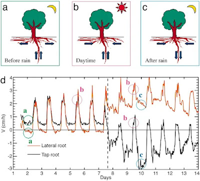
Sap velocity in the taproot and lateral root of P. robustum during the transition from the dry to wet season in the Floresta Nacional do Tapajós.(a–c) Schematics for water movement at nighttime before the rain (a), daytime before and after the rain (b), and nighttime after the rain (c). Arrows shown the dominant flow direction determined by sapflow. (d) Graph showing sap velocity. Positive values mean that water flows to the plant, and negative values means away from the plant into the surrounding soil. The dashed line represents a rain event (36 mm). See the text for a complete explanation.
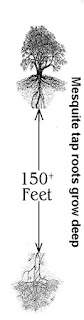
One of the first articles I ever read was a piece done above Todd Dawson'sresearch work on the role Sugar Maple (Acer saccharum)play in it's temperate forested ecosystem. It was exactly similar to something I had read about desert tree called Honey Mesquite (Prosopis juliflora) grows to a height of up to 12 metres (39 ft) and has a trunk with a diameter of up to 1.2 meters (3.9 ft).
Its roots are able to grow to a great depths in search of water: in
1960, they were discovered at a depth of 53 meters (175 feet) at an
open-pit mine near Tucson, Arizona putting them among the deepest known rootsystems.
"Mother Nature's Irrigators" by Todd Dawson
Of course I already had an interest on the theories and research work by an Austrian Forester and self taught Physicist Viktor Schauberger. This Schauberger spoke of healthy electrically charged water as only coming from deep within the Earth and moving upwards through the soil bringing with it along vital nutrients (or Salts as he put it) which nourished plants and other life on the surface in the process. The invaluable research work and physical naturalistic explanations provided by Todd Dawson, his team and a plethora of other modern day researchers was sadly something unavailable to Viktor Schauberger who was privileged to live at a time when most old growth forests were still intact and in their pristine state and he could observe first hand natural phenomena that we can only dream of now. With that early research in the back of my mind, this paragraph from the above linked article that caught my eye. It suddenly made sense of some of the things that seemed so mysterious. Take a look at what Todd Dawson and his team discovered with regards streamsidetrees. One would think that all that lush growth draws it's water hydration from off the surface waters. But not so. Read this one paragraph from the link from:
"Mother Nature's Irrigators"
"By comparing variations in isotopic concentrations taken from different sources, they were able to show that mature streamside trees do not use stream water but used deep groundwater. When Dawson came to Cornell in 1990, he looked for ways to combine his research in water use with his interest in woody plants and their distribution and physiology. During the summers of 1991and 1992, Dawson observed the water use of Maples."
Todd Dawsonmade a further research work of this streamside (Riparian Habitat) water use by Trees. These trees amazingly prefer the deep groundwater to the surface water abundant in what appears to be a healthy surface water situation. Take the time to read the paper they did on this in the link title:
"A LONG-STANDING axiom is that plant distribution is strongly influenced by soil moisture content1,2. While it has been shown that plant taxa inhabiting streamside communities receive or use more water3, it is assumed that this water is obtained from the stream adjacent to where they are found growing. Here we show, using hydrogen isotope ratio analyses at natural abundance levels, that mature streamside trees growing in or directly next to a perennial stream used little or none of the surface stream water. The deuterium to hydrogen content of both source and xylem waters indicated that mature trees were using waters from deeper strata. Although adult trees may have roots distributed continuously throughout a soil profile, it seemed that the most active sites of water absorbtion were limited to deeper soil layers. In contrast, small streamside individuals appeared to use stream water, whereas small non-streamside individuals used recent precipitation as their primary water source. Our analyses provide both a relatively non-destructive method for assessing water sources of plants and a means of assessing potential competitive interactions among cooccurring taxa. In addition, the method may aid in resolving the role of water in determining plant distributions in areas characterized by sharp soil moisture gradients."
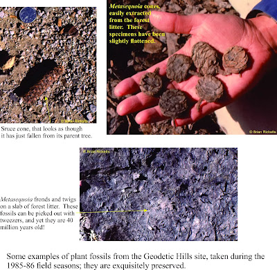
The above info has intrigued my interest because of my passion for finding evidence for an Ancient Earth's minerotrophic hydrological cycle which no longer exists on the Earth for the most part, though it does in parts such as Fens or Sahara Oasis where rain is not a factor. There are hints and clues everywhere and the technologies we can develop from learning about these natural processes are incredible and vitally important given the sad state of health conventional science has brought to mankind and the world around them. A huge discovery in the Arctic (Axel Heiberg Island) of ancient Dawn Redwood trees where actual wood which is not fossilized, but rather well preserved and mummified has provide Chemical Signature clues through Oxygen Isotope study as to the origin and source of water which hydrated those trees. Here is a sort quote of one researchers, Hope Jahren, in an interview of their finding of an ancient climate's past.
"Because the wood is unadulterated, the tissues hold a chemical record of weather patterns during the period the tree lived. Jahren studies carbon, hydrogen, oxygen, and nitrogen because these elements are taken from the soil, water, and air and incorporated into the tissue of plants and animals.
Jahren and her colleague Leonel Silveira Lobo Sternberg of the University of Miami in Coral Gables, Florida, are examining chemically different forms, or isotopes, of oxygen in these ancient redwoods to reveal weather patterns during the Eocene period.
Oxygen that a plant uses, said Jahren, comes primarily from water. Determining the chemistry of that water could reveal exactly where it came from. Rain that arrives after traveling long distances over land has a very different chemical signature than rain that travels over the ocean or just very short distances, she explained.
The researchers' analysis of the oxygen content of the wood revealed "a bizarre absence of oxygen-18, the heavy isotope," said Jahren. Water contains both oxygen 16—the more common and lighter isotope—and the more rare oxygen 18. The analysis suggests that the water contained almost exclusively oxygen 16."
National Geographic TodayMarch 26, 2002
"Arctic Redwood Fossils Are Clues to Ancient Climates"
Take a further 26 minutes if you are able and view this video on the Quest science video which tracks the field work of Todd Dawsonand his team. They take a look at our present hydrological water cycle and proceed to study just how it actually does work. You might say they are taking a more detailed approach by focusing in on the fine tuning of this hydrological cycle that is not necessarily observable the the average person. In fact Todd Dawson reveals more fresh water is store within the earth than on surface. Of course fast forward and this may not be true anymore. As the video's descriptive reference on the page states,
"Scientists at UC Berkley are embarking on a new project to understand how global warming is effecting our fresh water supply. And they are doing it by tracking individual raindrops Mendicino and north of Lake Tahoe."
Here is the video link which is only about ten minutes long. Enjoy!
"QUEST: Life of a Raindrop"
The animated illustration at the top of this page which shows the various functions of the phenomena called Hydraulic Lift & Redistribution comes from a paper Dawsonand other researchers did called,
"Root Functioning Modifies Seasonal Climate"
Abtract:Hydraulic redistribution (HR), the nocturnal vertical transfer of soil water from moister to drier regions in the soil profile by roots, has now been observed in Amazonian trees. We have incorporated HR into an atmospheric general circulation model (the National Center for Atmospheric Research Community Atmospheric Model Version 2) to estimate its impact on climate over the Amazon and other parts of the globe where plants displaying HR occur. Model results show that photosynthesis and evapotranspiration increase significantly in the Amazon during the dry season when plants are allowed to redistribute soil water. Plants draw water up and deposit it into the surface layers, and this water subsidy sustains transpiration at rates that deep roots alone cannot accomplish. The water used for dry season transpiration is from the deep storage layers in the soil, recharged during the previous wet season. We estimate that HR increases dry season (July to November) transpiration by ≈40% over the Amazon. Our model also indicates that such an increase in transpiration over the Amazon and other drought-stressed regions affects the seasonal cycles of temperature through changes in latent heat, thereby establishing a direct link between plant root functioning and climate.
From time to time I will add to this page further research done by Dawson and other who vision along the same line of thought and discovery. Keep checking for updated page.