The Trek from Western Arizona ending at the San Carlos Pass (Terwilliger)
 |
| Credit: Cartographer Karl Musser |
This is a map of the drainage basin of the Gila River in Arizona, New Mexico and Sonora in the United States and Mexico. This was also the exact route followed by Spanish Explorer Juan Bautista de Anza's journey to searching for easier trade routes to California and most all pioneers thereafter in a quest to reach the west coast. What is significant are Anza's detailed writing of events and natural physical features of the pristine landscape he traveled through which at that time was barely touched by the stain of European land mismanagement. While I am following Anza's dairy in this post, my main specific interest here is not on the human achievement in conquering unexplored territories, but rather on the Natural History and why such a more lush pristine vegetative landscape existed back then from a scientific mechanisms perspective and what lessons we can learn from this. Also, for me, practical applications are important. If there is nothing to learn and be applied, then any attempt at rebuilding these ecosystems back to what they once were would be a useless endeavor. The historical human intellect throughout history has always determined Nature to be incorrect, flawed and imperfect. This has only gotten worse with time. In so thinking, mankind has quite often rearranged the landscape to fit their commercial development ambitions while all the time destroying the very components which allow life and abundance to flourish. Hence, we have the present degraded modern day landscape around the globe becoming more and more devoid of most of it's biological life at a rapid pace despite all the well meaning, underfunded and under supported eco-activism efforts pointing the spotlight on this serious issue. So for the most part, I'm focusing on the natural world as viewed, observed and recorded by Juan Bautista de Anza and Pedro Font.
I'm intrigued by the written record of these two back to back explorations of Anza and the almost identical wet period I have first hand experience with between 1978-1984 in southern California. Most of what he wrote about the geographical areas which I am most familiar with, I can identify with his very accurate descriptions. It certainly would explain identical weather events and reasons for so much water they encountered, which in turn would explain much of the heavier vegetation they often encountered in many areas. Though I believe the climate and this particular winter weather events they experienced to be more robust than the one from the late 70s early 80s. Let us take a close look below at the next two images which are actually from recent climate events within the past three decades which illustrate the oscillating potential of the Colorado River Delta to feed excessive run off into the system which would have fed and sustained Lake Cahuilla. The Gila River drainage basin would also have heavily contributed in past history. Even today, were it not for the human control infrastructure which has dammed most of the Gila River tributaries, this part of the river in the west may well still have been a ribbon of riparian life. I think one of the sad thing is knowing that this Lake Cahuilla will never ever exist again under the present System. No doubt it would have refilled once again at some point in the future. But as we all know, this will never happen ever again under the present system as it stands now.
 |
| Department of GeoSciences - University of Arizona |
The Maximum inundation recorded by Landsat from scenes of April 13th and June 9th 1984 caused by abnormal snowmelt from the entire Colorado River Drainage of the upper basin. The extent of the inundation in the lower delta was 2,500 km2. For those who have been following this blog, you might also recall that I have also recently written a post about an interesting wetter time period between 1978 - 1984 which took place in the southwest, especially southern California for which I wrote about lessons learned from Bajadas. As an interesting side point here, look at the very northern finder of floodwater inundation on the left hand side of the satellite photo above. It's called Laguna Salada. This would be on the western side of the Mexicali Valley and west of the small Cocopa Mountain Range where the Mexican Hwy 2 makes it's way through a gap in these mountains on it's way west to Tecate and Tijuana. This same gap was traversed by Juan Bautista de Anza's expedition looking for a way through the mountains to the coast. The northern portion of this gap is what many of you people locally there know as Signal Mountain. This was an early geographic reference point for early travelers, who were alert to it by the natives who utilized it as a reference, hence the name "Signal Mountain". But interestingly, in his first expedition and dairy record of 1774, Anza writes down that before reaching this lake, they sighted a gap in the Cocopas Mountains, now known as the Lower Pass west of present day Mexicali, and through this they dropped down to the shore of a vast salt lake, Laguna Salada, and made camp near a marsh at it's dry north end, which they called, San Eusebio. On the banks of this lake they found stranded Sea fish, indicating that the lake was filled and emptied by tidal action from the surging waters from the Sea of Cortez or Gulf of California. At best the waters were brackish most of the time with the blending of the fresh waters from the Colorado River coming down from the northeast. Click here on this link below for a larger magnified view of that 1984 Landsat-Photo and you'll see the possible connection routes to the Sea of Cortez to this exact location which could well easily have been influenced by these tidal actions.
http://www.geo.arizona.edu/rcncrd/images/CRD_1984.jpg
 |
| Department of GeoSciences - University of Arizona |
This particular false colour Landsat image of the same location of the lower Colorado River delta that captures the drought turn around of May 24th and 25th of 1990. The reason for these two dates to create a snapshot, is that two Landsat scenes from different orbits are needed to capture the entire lower delta. What these photos illustrate is the power potential for a vastly greater diversified unique desert life ecosystem which, which while the river may have not always flowed at full capacity, the system was never the less more consistent and dependent than it is presently. Life in the delta area wasn't in the historical past shackled by a collection of flood control Dam infrastructure for which water was siphoned off by the Human sponges with greedy economic interests and dreams to fulfill. Still, I'm curious what the landscape looked like even during the time of Juan Bautista de Anza's historical trek through here in the 1700s. Clearly, there was always a wealth of water to influence and enhance life everywhere in this vast region. It's a pity most of them truly never realized the full potential of this natural richness.
I suppose this is a continuation of my obsession of knowing just what the Natural World's past once was like in the Natural World sense, more than any of the historical human accomplishments. Early explorers commissioned by the European countries like Great Britain and Spain required that their Government Funded Expeditionary Leaders make accurate and detailed records in journals or diaries. After all, the whole point of an expedition was to conquer lands for their homeland's expanding empire and document it's valuable potential for available resources which would eventually further enrich that Colonial Empire. So while there are some interesting encounters with the native indigenous peoples and other social interactions, I'm mainly looking for clues on exactly what was seen from an environmental perspective. These people are long dead now and any eyewitness accounts are now only left in their writings. This is why, when I first moved to Anza and heard stories of once vast forested areas there, I was keen on picking the memories of well known pioneer family descendants who were still living at the time and many of them in their 80s or 90s on those original homesteads. But more on that in some later posts on the Anza Valley itself when Anza discovered it.
 |
| http://navajopeople.org |
For the moment, I want to focus first on Anza's crossing of the Gila River and his decision to change direction from a direct route from the Colorado River along the present Interstate 8 freeway trek, then back to Yuma where he then took a more southerly route towards present day Mexicali which followed the old Lake Cahuilla-Colorado River channel feed which kept the lake viable. I'm still intrigued by a number of past natural historical events which appear to compliment each other with regards to the ancient Lake Cahuilla's decline and also what weather or climate effects this Lake Cahuilla may have had on surrounding southwestern United States with it's Lake-Effect weather phenomena. From some of the latest Scientific News and revelations recently, there are several natural phenomena and historical physical events that coincide with each other. I previous wrote about the research that came out about irrigation of the San Joaquin Valley having a positive rainfall effect by it's evaporation on the Colorado Plateau "Four Corner's" region. This is the post, Here . This is the area of the former ancient Native American people named Anasazi. My own personal speculation was that the far more massive Lake Cahuilla (as opposed to the present day Salton Sea) could well have had just such an effect on the Four Corner area as well as all of Arizona and even the mountain ranges to the west of Lake Cahuilla in California, especially during the time of monsoonal moisture feed which would have been strengthened by such a huge body of water as an evaporation source. Then there is the uncanny timeline of several historical events coinciding close with each other, but to make it short, please follow the posted page below.
Here: "Coincidental Geologic Phenomena Associated with same Timeline of Ancient Lake Cahuilla's Existence & Disappearance"
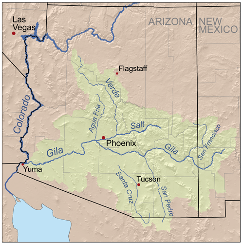
Okay back to Juan Bautista de Anza. In grade school I was always puzzled by the route we were always told in History class which the early pioneers traveled on the southern route to California. Basically, this is following the entire stretch of the Gila River drainage from central Arizona to Yuma. Seriously, from a human perspective, if you've ever traveled along this route especially on Interstate 8 from Gila Bend to Yuma, there's almost literally nothing there. Vegetation is sparse even in the dry washes and flood plains. Of course back then there were no dams to prevent the free movement of water from flowing on the surface where lush vegetation would have been abundant. Even if & when water wasn't always on the surface, such very high underground water tables would have made it easy for riparian trees like Fremont Cottonwoods, Arizona Ash, Arizona Sycamore and some willows still would have thrived. Also massive mesquite bosques most likely would have been prevalent on both sides of the Gila River which would have most likely included other dense deep rooted vegetation like Palo Verde, Ironwood, etc.Even Saguaros would have been more abundant with more nurse trees to mother their their delicate youth. A good example of what I'm taking about would be for anyone to visit the upstream Hassayampa River Preserve to the north at around Wickenburg Arizona.
 |
| Photo: Tommy J. DeBardeleben |
The image above is of the Hassayampa River near Wickenburg Arizona. Notice the lush river valley with surrounding hillsides covered in heavy Mesquite scrub, Saguaro and Ocotillo ? Such habitats most likely were found historically all the way from central Arizona to Yuma and the Colorado River at one time. This region in the photo specifically is the Nature Conservancy's Hassayampa River Preserve which also contains some Arizona Sycamore and California Fan Palms. The river also contains native fish like the Bony Tail Chub and Colorado Squawfish (or Pikeminnow) which would indicate a past historical connection to the mighty Colorado River and other water courses within the Gila River drainage basin. Such biodiversity no doubt existed on the hot barren floodplains of the desert landscape from Gila to Yuma Arizona. Early travelers could well have made safe journeys even during summer months
 |
| Credit: San Pedro National Conservation Area |
I'm referencing this photograph of the San Pedro River which itself is part of the upper Gila River watershed. Such a lush scenery may well have been an example of the ribbon of life of the entire Gila River system all the way down to the Colorado River through the western Arizona desert regions for which it is presently nothing more than vast stretches of dry sparse vegetation (with the exception of some stubborn stunted Tamarisks) floodplains. You must consider that there were no hydrological disruptions upstream where present day Arizona has a network of Reservoir Projects for it's commercial ventures. Such free flowing water would have always been present and if if there were times of drought, the richness of underground water storage would have kept the riparian system alive and well.
 |
| Credit: Zillow.com |
This photo is a land comparison aerial photo from a real estate venture company many have seen as Zillow, but it illustrates the vast flood plain landscape potential east of a the Mohawk-Wellton area in a small town called Tacna and/or Dateland Arizona. The description for this real estate property which as you can see are not fit for conventional Agricultural usage, but instead proposes this:
"Perfect for investors/land/Solar developers w/imagination and vision. Make it a reality! Offered at only $1,665 per/ acre."
But why a industrial Solar Farm way out there ? Reading further the print on the land advertisement description reveals why.
"There are agricultural water wells located in the Gila River flood plain & aquafier that produce 2,500+/- gallons per min. less than 3 miles S of the S boundary, & water rights give access to all the water beneath."
Wow, with the right commercial water pump you could literally suck up out of the ground 2,500 of water per minute. The underground aquifer here is massive and contains incredible amounts of what are termed fossil water which has been deposited through natural injection into this massive floodplain over thousands of years. The large agricultural ventures are everywhere along this ancient river bed. Mostly water loving crops. But even a large commercial Solar Farm would have needs of tremendous amounts of water. What most people don't realize is these so-called sustainable energy schemes need regular cleaning of their Solar Panels to function properly and efficiently, hence their wasteful thirst for water is anything but sustainable. The unsustainable agricultural practices surrounding this area are also depleting the underground reserves and with the Colorado river drainage basin in trouble from years of drought, it too will not be able to provided needed canal transported waters to artificially recharge these underground aquifers by means of industrial percolation ponds. Never the less, once again we see that this area physically is no longer in a healthy complete vegetative cover sense, what it was once was in the historical past.
 |
| Image by Barry Lawrence Ruderman |
This older historical image of the Gila River entering the Colorado River, gives us a real life feel in an illustrative sense, of just how mighty the Gila River once was, although today it being a mere puddle [if even that] of it's former glory. The description Juan Bautista de Anza gave of crossing it, was that they needed help from the Yuman Indians to cross what was described as the turbulent Gila River. Incredibly, this was in the winter time and I'll quote from Pedro Font's diary. For the purpose of defining terminology, the word "League" is used for traveling distance. The National Park Service has a glossary for the Anza Trail documents and has this to say about the terms like 'league' - 1 league is about 2.56 miles. Keep this page as a reference for terms other words and character references. Here is the description of days and dates. I won't quote all of it, but between the dates of November 3rd 1775 at the point at the present Gila River Indian Reservation where they camped near a pond which had bad water and made many of them sick. Interestingly along this trek to Yuma, Pedro Font references several small ponds or even lakes that they camped at which were quite a distance away from the river's banks. This indicates to me the great richness of ground hydration on either side of the river in the floodplain. But he had this to say about this spot near present day Maricopa.
"Toward the west of this place there is a mountain range which runs to the north, and ends at a distance of three leagues; beyond this termination, and farther down stream, the Río Gila joins with the Río de la Asunción, which is large, and about three times as great as the Gila."
Interestingly, the present day Salt River (Río de la Asunción) is much wider at the meeting of the Gila and Salt. It's also worth noting that from a natural history perspective, the North American beaver (Castor canadensis) historically flourished on the river. In an historical account George C. Yount, a fur trapper with the Pattie expedition wrote on February 1, 1863,
"...we began to ascend the Black River [Salt River]...We found it to abound with beavers..We followed up this stream to where it forks in the mountains; that is to say, about 80 miles from its mouth."
( "The Chronicles of George C. Yount: California Pioneer of 1826" )
There is no reason to believe there weren't any abundant beaver populations during this 1775 trek, if they were very numerous during the 1863 survey and trapping expedition. This would also indicate permanent water presence through the entire river system in this blistering hot desert regions. And I personally know they are abundant in the Colorado from Yuma northward, as I use to find the best fishing holes in the early 1970s along either side of the Colorado River backwater areas behind beaver dams with the Picacho State Recreation Area and Imperial National Wildlife Refuge. To be honest, I'm very much inclined to believe that the Beaver movement into the lower Colorado River valley and eventually the delta region at the Sea of Cortez more easily may have been facilitated by way of the Gila than from out of the muddy and rocky turbulance of the much more difficult terrain prior to and after the present Grand Canyon National Park. Not impossible, but a much more difficult maneuver for a small animal. Just my biased assumptive without evidence two cents *smile*
The dairy continues and the description from the Camp east of present day Gila Bend all the way through to the present day town of Welton AZ, where they camped along side another pond or small lake which Pedro Font described as brackish water. This appears to be just west of Welton AZ. But in the camps prior and treking they did, several times it is mentioned they had to ford the river at several points and there were other side ponds or small lakes. Again, the riparian floodplain vegetation would have been in great abundance and at great distance from the Gila River main channel as Font's description of the brackish pond west of Welton mentions this:
November 25. -- "We set out from the Cerro de Santa Cecilia del Metate at a quarter to ten in the morning, and, at about two in the afternoon, halted beside a brackish pond about a league from the river, having traveled some five leagues, west by north. A Yuma Indian on horseback came to meet us on the road; he was sent by the chief Palma to tell us that he was waiting for us in peace, with all his Yumas and the Jalche dunes, who had come down to the junction of the rivers to see us in consequence of a message sent to them from Agua Caliente."
There are a couple of interesting things in this log. First the mention of Cerro de Santa Cecilia del Metate. This is an area in Welton called Antelope Hill where metate grinding holes and petroglyphs can be found. From this point he describes this pond as being one league from the river. Remember ? one league equals 2.56 miles ? This reveals how high the water table was through this entire giant floodplain. Again, even if this area almost three miles away from the main channel were not large old growth riparian woodlands, at the very least many healthy large mesquite bosques could have existed, where now there are only bone dry rocky desert landscape. Actually, it's almost a moonscape, with the exception of human activity like housing and now giant increasing industrial agricultural ventures. Pedro Font now continues about their having to cris-cross the Gila River time and again before actually coming to the Colorado. Again, it just makes you wonder, how big was this thing anyway ? Especially when you consider it's present condition which is almost nothing by comparison today.
November 26. -- "We set out from the brackish pond at a quarter past ten in the morning, and, at two in the afternoon, halted beside the river, having travelled some four leagues to the northwest."
November 27. -- "We set out from the bank of the river at half-past nine in the morning, and, about twelve, halted at a pass through which the Río Gila runs narrowed, having travelled some two leagues to the west-northwest. A relative of the chief Palma came out to meet us on the road, and, as soon as we halted, the chief, Salvador Palma himself, came to see us, and another chief, to whom we gave the name of Pablo, accompanied by several young Indians; they greeted us with many demonstrations of pleasure."
November 28. -- "We set out from the pass and the banks of the Gila at a quarter past nine in the morning, and, at two in the afternoon, halted on the shore of the Río Colorado after fording the Río Gila for the third time, having travelled some five leagues, west by south. The Yumas lodged us in a shelter of boughs that the chief Palma had ordered to be made here as soon as he knew of our coming. Many Indians of both sexes came to visit us, very festive and elated. About a league down stream from this place, the Río Gila joins the Río Colorado. "
November 29. -- "Search was made for a ford in the Rio Colorado, and when it was found a road was cut through the underbrush and trees along the banks, with the object of crossing on the following day."
November 30. -- After mass, Carlos, the governor of the Cocomaricopas, who had come with us to ratify peace with the Yumas, returned very contented to his home. We set out from the shore of the Río Colorado at nine in the morning, and, at one in the afternoon, the entire expedition, people and pack-animals, had completed the fording of the river without any particular accident. We crossed it where it was divided into three branches and a small backwater, and remained beside the Colorado, having travelled about one short league to the north. I estimated the width of the river, where we forded it, at some three or four hundred yards, and this at a time when the water is at its lowest, for when the river rises it is leagues wide."
December l. -- "We remained here for the purpose of erecting a hut at the village of the chief Palma for the habitation of Fathers Francisco Garcés and Tomás Eixarch, who were to stay at this river. The chief Palma dressed himself in the suit that was given to him in the name of His Excellency the Viceroy."
December 2. -- "The work of erecting the hut was continued, and for this reason we remained."
December 3. -- "We set out from the bank of the Río Colorado at half-past ten in the morning, and, at midday, arrived at the village of the chief Palma, having travelled about one league, west by south. The rest of the day was occupied in finishing the hut."
 |
| Image - visityuma.com |
This is the confluence of the Colorado and Gila Rivers (then known as the east wetlands) at flood stage circa 1890.You can see the infamous Yuma Territorial Prison on the right up on the Granite hill outcropping in between which the river narrows. This would be looking south and east from the California side of the River. Where you look to the left of the photo and the vast lake built up behind these narrows. Anyone who has traveled here and seen this region to the east knows that this area is all farmland and some small industry. The river today is nothing more than a trickle as a result of numerous upstream Dams compared to it's unbridled wild river volume which would do as it pleased way back in history before Europeans. But it is interesting to think about the potential for flood even as Font recognized, no doubt with help by historical accounts relayed to him by the Yuma (Quechan) Indians themselves. Keep in mind the above photo when you read this once again:
"We crossed it where it was divided into three branches and a small backwater, and remained beside the Colorado, having travelled about one short league to the north. I estimated the width of the river, where we forded it, at some three or four hundred yards, and this at a time when the water is at its lowest, for when the river rises it is leagues wide."
~~~~~~~~~~~~~~~~~~~~~~~~~~~~~~~~~
At this point, I've explained really all I can about the description of a once more massive riparian ecosystem which once existed in Arizona and this is well known by most experts. But it's wonderful to review first hand account on the matter by someone present almost 300+ years ago. I'm now taking a very giant leap to a location around the San Sebastian Marsh and delta region where the San Felipe Creek runs into the Salton Sea. This bypasses the part of the trip through Baja Mexico. Something very unique and interesting event that happened here this one particular winter of 1775. Something not likely to happen again weather or climate-wise. Here, is further dairy writings from Fray Pedro Font. Keep in mind this was still wintertime and at this point now extremely frigid in the desert.
December 13. -- "We set out from the dry gully at nine in the morning, and, at half-past three in the afternoon, arrived at San Sebastián, which is a small village of the mountain Cajuenches, having travelled some seven long leagues to the north-northwest, with a slight inclination to the north. "
December 14. -- "The day broke very cold, and, in the middle of the forenoon it snowed, and while it was snowing the cattle arrived. It was decided to remain here until all the people of the other two parties of the expedition which were behind could gather."
December 15. -- "At noon the sergeant arrived with the second party of the people of the expedition. December 16. -- We expected the third party today, but it did not arrive, as it was delayed by the snow."
December 17. -- "The lieutenant arrived in the afternoon with the third party, which had met with some delays on the road. I observed the latitude of this place, and found it to be 33° 8'; so I say: At the Ranchería de San Sebastián, December 17, 1775, meridian altitude of the lower limb of the sun, 33° 10'."
Wow, for all who are familiar with this area's normal moonscape look and appearance near the Salton Sea, a fierce snow blizzard is the last thing you could possibly imagine. But never the less, this is what took place. Switching now to Juan Bautista de Anza's Diary and account of the same weather phenomena:
Wednesday, December 13. -- Day broke with threatening signs of snow, and indeed at daylight a few flakes fell, and it was seen that they were more abundant in the sierra which we had near by on our left. Nevertheless we set forth on the march at half past eight, going north-northwest over better terrain than the day before. We traveled in this direction about five and a half leagues, finishing the day's march by going another league and a half to the north, in order to reach the Marsh of San Sebastián , which we succeeded in doing at half past three. The few heathen who live here came out to welcome us with great demonstrations of affection. At the time when we halted the strong cold wind, which had been very hard on our people, especially the women and children, quieted down somewhat. The sky also cleared a little more, and we were able to see that the sierras through which we had to travel were more deeply covered with snow than we had ever imagined would be the case. Taking advantage of this quiet weather, I had all the firewood gathered that was possible, though it was not much because the region is lacking in it, in order to withstand the cold wind which came up again with great force at five o'clock with preludes of rain and snow. These inclemencies continued until night. -- 33. From Tubac to the Ciénega de San Sebastián, 144 1/2 leagues.
Thursday, December 14. -- As soon as day began to dawn it commenced to snow with fierce and extremely cold wind, which continued the entire day, and for this reason it was not possible to march. And since it is probable on account of the snow that on the next journey, to San Gregorio , there will not be such a shortage of water as we have assumed, I have decided to wait in this place for the two divisions which are following me. At twelve o'clock the cattle arrived. As I have said, they came by a different route from the rest of the expedition, and in bringing them we lost ten head which became tired out. These animals, notwithstanding that they had not been watered for four days, needed so little in this present season that even when they were taken to the verge of the water most of them preferred to eat rather than drink. The second division did not put in its appearance during the whole day, although it ought to be here, and for this reason I conclude that it encountered the same storm as ourselves and was prevented by it from marching. At eleven o'clock at night it stopped snowing, but the mountains and plains continued to be so covered with snow that it looked like daylight, and there now followed a very severe freeze, as a consequence of which this was a night of extreme hardship.
Friday, December 15. -- At daybreak it was very windy, and the snow which had fallen the day and the night before was very hard from the freezing weather which had preceded, as a result of which six of our cattle and one mule died. At a quarter past twelve the second division began to arrive, in charge of the sergeant . The people were crippled by the storm, which overtook them midway between Santa Rosa and here. In spite of all their efforts to reach here yesterday they were unable to do so, and on the way several persons were frozen, one of them so badly that in order to save his life it was necessary to bundle him up for two hours between four fires. As a result of these inclemencies five saddle animals died in their division. But aside from these there were no disasters on their march, and, indeed, because the division was slower than the first and came by a made road, with wells open, it was more conveniently supplied with water than the former division.
Saturday, December 16. -- I remained in this place awaiting the third division. This morning four of our cattle died from injuries and cold because of the severe freezing weather. At eleven o'clock they informed me that when they were looking for some saddle animals which had disappeared from sight, they found that they were being driven off by four of the heathen who had come to see us. I therefore ordered the sergeant and four soldiers to go and follow them, with orders that if they should overtake the thieves in the open or in their villages they should three times require them to deliver the stolen animals, giving them to understand that if they did this again they would feel the force of our arms, but that they were not to punish them with weapons except in case the Indians by force of their own arms should attempt to retain the saddle animals or refuse to deliver them. At seven o'clock the sergeant returned with the report that he found the mounts in two different villages, distant about four leagues, where not a single man was to be seen, but he gave the women who were there to understand what his orders were, so that they might report them to their men.

I'm going to pause here and focus on this San Sebastian encampment's location and the surrounding terrain and what there is of plant life as it is now. What an incredible account of a blizzard from this area. For those who have no clue about this area, I've written about it from my visit here with my wife and brother back in June 2011. I wanted to see how well the SDSU Mesquite Dune Experiment had become since my first seeing it back in the 1990s. This general location of the expedition encampment is same exact area I stopped to inspect and take photos of the Mesquite Dune Project. They were trying to artificially recreate the mesquite mounded sand dunes which were once common in this area and numerous other regions now developed. These mounds are very important wildlife islands. The photo above right is Highway 78 looking towards the west and mountains in San Diego County. The photo below is of the project and surrounding very dry desert terrain where the last thing you would expect is a snow storm.
 |
| photo: Mine Barbed Wire Fenced off Mesquite Dune project. |
Lessons From a Mesquite Dune Project
 |
| Photo: Mine |
Well, that is pretty much about what the surrounding terrain looks like. I have no idea what it once was when Anza came through, other than the description of their following the San Felipe Creek channel westward and encountering pasture ground in various places for their cattle and horses. But something else he said I really want to touch on as far as the native peoples he encountered here. It actually helps in trusting the accuracy of his account of events on this expedition.
Sunday, December 17. -- Since the third division did not appear yesterday, at seven o'clock in the morning I sent two soldiers to meet it with twenty saddle animals , in order that they may have new mounts to replace those which may be tired out or made useless because of the cold. At half past three in the afternoon the third division arrived at this place in command of Alférez Don Joseph Moraga . His forces were in worse condition than the two earlier divisions because the storm of snow and cold had caught them in a more exposed position, and as a result several persons were frozen to the point of being in danger of death. From the same cause six saddle animals were left by the wayside and four others died. In attending to his division, providing fire for them, and in other services for their relief, this officer so exposed himself that he contracted very severe pains in his ears, and although these have been cured, the weather is so bad that he has been left totally deaf in both ears. Today two more of our cattle have died as a result of injury and cold. In the midst of these misfortunes which have been caused us by the snowstorm, with the loss of the animals which have died, it almost seems to have been designed for the benefit of the health of our people, for whereas nine days ago we counted more than fifteen invalids, three of them dangerously ill, today there are less than five of the first class and none of the second. Their sudden recovery , which we have not hitherto experienced since we began the march, is attributed partly to the many watermelons which were eaten at the lake of Santa Olaya. The details concerning this site and the people who inhabit it I set forth in my former diary, and since I have nothing to add to what I have already said there, I will only note that the misery inseparable from all Indians abounds in these more than we have witnessed anywhere before reaching this place, but we shall be able to equal it with those from hereforward, of whose shortcomings likewise I gave an account in my diary cited. I also noted therein what happened to us then from the pasturage , which made our saddle animals useless because it purged them so. During the days that we have been here this time this trouble has not been experienced, and we attribute this to the fact that with the present rain and snow the saltiness of its leaves has decreased. This notice may be helpful as a means of removing fear of trouble at such a season as this.On a botanical note, he specifically mentions the rapid recovery of many of his fellow expeditionary force - who were near death from the cold - for which he attributes to the eating of these Watermelons traded from the Cajuenche nation at a location in present Mexico which was then called lake of Santa Olaya. One has to wonder what type of vegetable crop this was. He also often uses a term called Calabashes when referencing some of the foods they traded from the natives, which can refer to either a bottle gourd kind of squash or watermelons. So I'm extremely curious as to exactly what these were. This is what got me interested in botany in the first place way back when, wondering just what the natives lived off of as far as native plant foods on such an inhospitable landscape. No doubt there was much trading going on between these natives, with produce and the resulting saved seeds[fortunately, no corporate patenting B.S. existed as yet] was a big part of their making a living off the land.
 |
| illustration Bill Singleton |
Dances With Myths: Indigenous Native Peoples and Fire Ecology.
 |
| Photo courtesy of the UNLV |
 |
| Photo - Timothy H. O'Sullivan,, 1840-1882 |
Ultimately, I have found most of Anza's writings credible, even from my own personal hands on observations, of plant life and geographical locations to be accurate. And though I've gotten a bit off track here at the end of my post, it was necessary to reveal and backup the accuracy of his natural world observation and documentation also. This will be even more important as we view his writings based on observations of the San Jacinto Mountains next time.
~~~~~~~~~~~~~~~~~~~~~~~~~~~~~~~~
 |
| Image by Google Earth |
~~~~~~~~~~~~~~~~~~~~~~~~~~~~
Reading References:
Arizona Geological Survey: "HISTORICAL GEOMORPHOLOGY OF THE GILA RIVER"
http://www.anzahistorictrail.org
http://www.sandiegohistory.org/books/pourade/explorers/explorerstranslation11.htmThere are other great National link references, but the present political playground squabbling by both political sides in the USA renders these links sterile and impotent. Maybe I'll post them here when the Truant Officer blows the whistle and sends both of them to the detention room with dunce caps.
No comments:
Post a Comment
Thanks for visiting and stopping by with your comments!
I will try to respond to each comment within a few days, though sometimes I take longer if I'm too busy which appears to be increasing.