Major Geological Phenomena from Earthquakes to Volcanoes had a major effect & impact on Ancient Lake Cahuilla's existence and disappearance, which in turn effected not only the Ancient Anazasi civilization, but also the climate of the Natural World within the southwest which previously benefited from the Lake's hydrological influence.This page will deal strictly with studies and their Abstracts on evidence of both earthquakes and volcanoes during this same exact historical timeline.
~~~~~~~~~~~~~~~~~~~~~~~~~~~~~~~~~~~~~~~~~~
So as not to rehash what I've previously written, see the post:
What exactly is the weather phenomenon known as the "lake effect"?
Trenches excavated across the Superstition Mountain fault in the Imperial Valley, California, have exposed evidence for four prehistorical earthquakes preserved in displaced lacustrine stratigraphy associated with ancient Lake Cahuilla.
The presence of shoreline peat accumulations along with abundant detrital charcoal allows for high-precision age determination of some stratigraphic units, thereby providing constraints on the timing of three of the paleoearthquakes. These three events occurred within a 480- to 820-year interval during the past 1200 years. The most recent earthquake (event 1) occurred during a fluvial phase of deposition between A.D. 1440–1637, immediately prior to the inundation of the Cahuilla basin at about A.D. 1480 and 1660. A channel margin was offset 2.2 +0.4/−0.15 m in this rupture, suggesting an earthquake with a magnitude ≥7.
The penultimate event (event 2) also occurred during fluvial deposition after A.D. 1280 but before another lakestand at A.D. 1440–1640. Lateral slip could not be resolved for event 2. However, based on juxtaposition of dissimilar units and the amount of deformation produced by this event, it is presumed that this was also a large earthquake. The timing of event 3 is constrained to have occurred between about A.D. 820 and 1280. This event is represented by several fractures and small displacements that rupture up to a distinct stratigraphic level or event horizon. Slip was not resolved for this event. Finally, the timing of event 4 is very poorly constrained to between A.D. 964 and 4670 B.C. Undoubtedly, many events may have occurred during this period. Notably, the past three earthquakes occurred within a period of less than 820 years, and it has been over 350 years since the last earthquake."
Timing and slip for prehistoric earthquakes on the Superstition Mountain Fault, Imperial Valley, Southern California
Trenches excavated across the Superstition Mountain fault in the Imperial Valley, California, have exposed evidence for four prehistorical earthquakes preserved in displaced lacustrine stratigraphy associated with ancient Lake Cahuilla. The presence of shoreline peat accumulations along with abundant detrital charcoal allows for high-precision age determination of some stratigraphic units, thereby providing constraints on the timing of three of the paleoearthquakes. These three events occurred within a 480- to 820-year interval during the past 1200 years. The most recent earthquake (event 1) occurred during a fluvial phase of deposition between A.D. 1440–1637, immediately prior to the inundation of the Cahuilla basin at about A.D. 1480 and 1660. A channel margin was offset 2.2 +0.4/−0.15 m in this rupture, suggesting an earthquake with a magnitude ≥7. The penultimate event (event 2) also occurred during fluvial deposition after A.D. 1280 but before another lakestand at A.D. 1440–1640. Lateral slip could not be resolved for event 2. However, based on juxtaposition of dissimilar units and the amount of deformation produced by this event, it is presumed that this was also a large earthquake. The timing of event 3 is constrained to have occurred between about A.D. 820 and 1280. This event is represented by several fractures and small displacements that rupture up to a distinct stratigraphic level or event horizon. Slip was not resolved for this event. Finally, the timing of event 4 is very poorly constrained to between A.D. 964 and 4670 B.C. Undoubtedly, many events may have occurred during this period. Notably, the past three earthquakes occurred within a period of less than 820 years, and it has been over 350 years since the last earthquake."
~~~~~~~~~~~~~~~~~~~~~~~~~~~~~~~~~~~~~~~~~~~~
San Andreas Fault Earthquake Chronology and Lake Cahuilla History at Coachella, California
Abstract:
The southernmost ∼100 km of the San Andreas fault has not ruptured historically. It is imperative to determine its rupture history to better predict its future behavior. This paleoseismic investigation in Coachella, California, establishes a chronology of at least five and up to seven major earthquakes during the past ∼1100 yr. This chronology yields a range of average recurrence intervals between 116 and 221 yr, depending on assumptions, with a best-estimate average recurrence interval of 180 yr. The most recent earthquake occurred c.1690, more than 300 yr ago, suggesting that this stretch of the fault has accumulated a large amount of tectonic stress and is likely to rupture in the near future, assuming the fault follows a stress renewal model. This study also establishes the timing of the past 5–6 highstands of ancient Lake Cahuilla since A.D. 800. We found that earthquakes do not tend to occur at any particular stage in the lake cycle.
~~~~~~~~~~~~~~~~~~~~~~~~~~~~~~~~~~~~~~~~~~
Prehistoric Native American Responses to Ancient Lake Cahuilla Jerry Schaefer Ph. D.The local Cahuilla Indians’ oral history as told to expedition leaders confirmed William P. Blake’s observations:
"When questioned about the shoreline and watermarks of the ancient lake, the chief gave an account of a tradition they have of a great water (agua grande), which covered the whole valley and was filled with fine fish. There was (sic) also plenty of geese and ducks. Their fathers lived in the mountains and used to come down to the lake to fish and hunt. The water gradually subsided “poco” a “poco,” (little by little,) and their villages were moved down from the mountains, into the valley it had left. They also said that the waters once returned very suddenly and overwhelmed many of their people and drove the rest back to the mountains" (Blake 1857:98)
 |
| Credit; Fish and Wildlife Service |
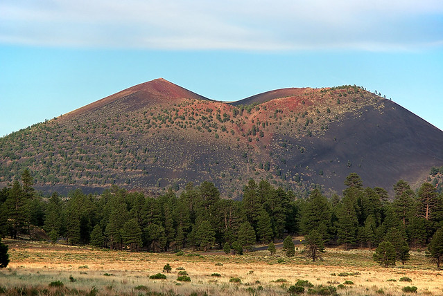
Moonset at Rock Hill, one of five volcanoes that comprise the Salton Buttes. The buttes last erupted between 940 A.D. and 0 B.C., not 30,000 years ago, as previously thought, a new study finds. Salton Buttes far younger than first imagined"
The above article from last year was absolutely amazing and incredibly fascinating when you consider there are five volcanoes at the southern end of the Salton Sea and the timeline of their eruption in 940 CE (AD) is also close to the 1064-65 CE (AD) time period when Sunset Crater (near Flagstaff Arizona) was first formed and blew it's top multiple times 150 years thereafter. And both of these coincide with the decline and degradation of the Colorado Plateau and fall of Anasazi civilization and lake level lowering of Cahuilla. Is there a connection ? Who really knows, but it is intriguing. Clearly the entire southwest was geologically more active, especially with reference to Volcanism, than at present. One now has to ponder whether any of this Volcanism and San Andreas Fault zone uplifting may have contributed to any shifting of the Colorado River's pathway in it's massive delta from a westerly flow direction which sustained Lake Cahuilla to a more southerly direction to the Sea of Cortez. Mind you, the river pattern seems to have altered on and off over centuries of time with perhaps the Lake Cahuilla filling, disappearing (completely or partially) and refilling to various levels.Live Science: Salton Sea Mystery Volcano Solved
However it's influence over climate and more heavily vegetated ecosystems in the southwestern United States is intriguing. Even during such times as lower lake levels, such vegetative systems would have remained intact and been one of hydrological sustainability much like that of the Amazon River Drainage Basin for which Dr Leonel Sternberg studied the sustainability of the Amazon Basin during the dry seasons where no Ocean influenced precipitation had any effect on the cyclical rainfall patterns which involved hydraulic lift, redistribution, descent and finally evapotranspiration into the upper atmosphere which created it's own self-sustaining recycling or re-precipitating of the water cycle. (see article: WATER RELATIONS OF TROPICAL ECOSYSTEMS ) Such a system is what I believe may have to some degree (with a variable degree of circumstances) sustained the southwest forests (all systems of vegetation) during drier periods. Ignorance on the part of Europeans and eastern American Colonist right on to present day on how dryland areas work and proper land management has contributed towards it's rapid deterioration. Agricultural techniques and practices which may have worked in wetter Europe and eastern North America should never have been practiced out west. The same historical issues and problems have degraded similar places in Africa, Australia and South America where these same European Conquerors were determined to expand their world empire ambitions no matter what the cost to the environment and/or indigenous peoples.
 |
| Credit: Alan English (Arizona) |
USGS: Sunset Crater Eruptive History
 |
| Image from Virginia Tech |
 |
| credit: aaroads.com |
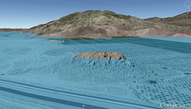
Travertine Rock along Hwy 86 near the border of Riverside and Imperial Counties at the Southern end of Coachella Valley and northern Imperial Valley. This point of reference is very well known among travelers. At the top is the ancient Cahuilla Lake sea level water mark."
 |
| Credit: Google Maps via Thomas E. Teske (El Centro, CA) |
This is from Google Maps with enhanced animation of the ancient water level of Lake Cahuilla at Travertine Rock along Hwy 86 between Coachella and Brawley CA.
 |
| Credit: Google Maps via Thomas E. Teske (El Centro, CA) |
Coachella Valley near Thermal & Valerie Jean with Santa Rosa Mountains in the background, and with enhancement of blue animation illustrating ancient sea level of Lake Cahuilla.
 |
| Credit: Google Maps via Thomas E. Teske (El Centro, CA) |
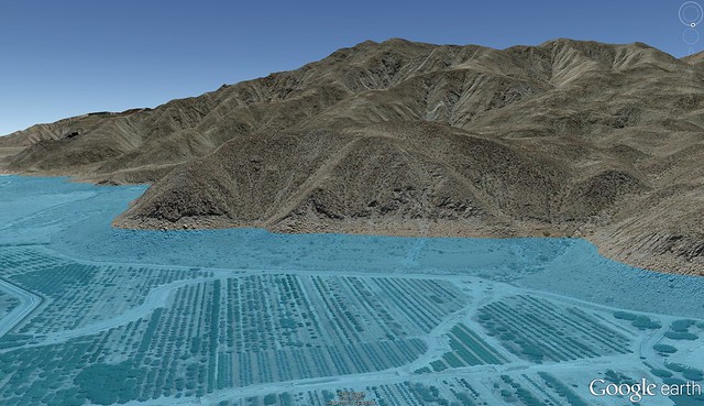
This is a large enhanced map location from the southwestern east of the present Salton Sea. Notice San Felipe Creek to the north (top) and Fish Creek Mountains to the left. Superstition Sand Hills are on the right with Carizzo Wash which runs down from Ocotillo California right in the middle where is says beach. The light blue colour animation illustrates just how far west the ancient sea came west towards the Fish Creek mountains.
 |
| Credit: Google Maps via Thomas E. Teske (El Centro, CA) |
This is a Google map of Fish Creek Trail in Anza Borrego Desert State Park which is west of the Salton Sea and south of Hwy 86 and San Felipe Creek (Wash). Clearly there was a definite connection which reveals just how the isolated population of Fish Creek Pupfish had their origins.
 |
| Credit: Google Maps via Thomas E. Teske (El Cantro, CA) |
 |
| Credit: US Geological Survey Maps |
| Credit: USGS The Genius among mankind have known all along how Earth's mechanisms work. But selling them- selves into slavery to global Corporate and various National interests speaks volumes as to where the hearts lay. |
~~~~~~~~~~~~~~~~~~~~~~~~~~~~~~~~~~~~~~~~~~
Further interesting references on Lake Cahuilla and earthquake influences, also Vegetation and Rainfall increases:
Flooding of Ancient Salton Sea Linked to San Andreas Earthquakes
Nature: "Observations of increased tropical rainfall preceded by air passage over forests"
Tropical Storms Linger Longer Over Wet Land & Fizzle Over Dry, But in Truth it's a Universal Phenomena Globally Speaking
Air passing over vegetation produces about twice as much rain as air passing over sparse vegetation according to a report in Nature. Their findings highlight the importance of not only tropical rainforests in maintaining regional rainfall patterns, but actually all forested systems, including important ecosystems as Chaparral Plant Communities. This study also suggested that current rates of deforestation of the Amazon will lead to large reductions in regional rainfall. This has actually taken place in other areas of Earth, but has for the most part been ignored until the destruction of Amazon Basin showed dramatic change that is now effecting systems globally.
Honestly, I can't explain why we humans have to mess with nature...sigh...My kids at school constantly find tiny seashells in the sand out on the playground. And, that's in Coachella. Wasn't "Coachella" originally named "CONCHELLA"? Conchella would mean "little shells"...
ReplyDeleteYes that is correct and I have no doubt that the Spanish word was used, with maybe the present spelling and pronunciation being Anglesized.
DeleteThis may look familiar:
ReplyDeletehttps://youtu.be/8uqFGz1dmBc
Email me if you want more info.
Rob