Friday, May 9, 2014

Anza's Dairy & the Lessons Learned

 Understanding the importance of Riparian Ecosystems & making Practical Application in Restoration of things observed
Image: Regional Conservation Authority

San Jacinto River west of Hwy 74 bridge across from  Cranston Station

Traditionally when mankind created settlements which became towns and eventually large cities, they mostly were located on the banks of rivers and/or delta outlets into the world's oceans. Their economies demanded it and they of course were in great need of available supply of fresh water. Seriously, look on any world map at all of today's present cities anywhere around the globe and view where they are mostly located. Of course in today's world of modern technological advances, it is no longer necessary for any city to be located within close proximity to such an ecosystem. Many centuries ago, the world's most well known classical rivers meandered this way or that through a dense forest of riparian woodlands. This includes the once lush green San Jacinto River Valley in which such a lush environment was actually described by those first Spanish explorers as predominantly Cottonwoods, Sycamores, etc. But we also know from other journal contributors that these woodlands held such food bearing plants as California Fan Palms with their dates, Elderberry trees, roses and Fray Pedro Font made mention of native grapes everywhere, starting in Bautista Canyon. Such an overflow of variety also filled with vast backwater marshlands on either side of the heavily dense old growth forests along the main river channel attracted a myriad of waterfowl along with large and small animals which would be lured by the abundance of natural food sources.

Image - Wikimedia
In my last post on this subject, I posed a question to the illustration here and asked, "Can anyone else picture or visualize in your mind's eye the lush San Jacinto River Valley floodplains with California Grizzly Bears fishing for Southern California Steelhead Trout as they make their way east to the South, Middle and North Fork Canyons to spawn ?" Of course anything would be possible if the climate and the natural hydrological circumstances I brought up were untouched by man. The native Southern California Steelhead Trout could spawned in the San Jacinto River, and grizzly bears may well have roamed its shores in search of food. So lush was this landscape and so unusual was it in an otherwise dry country that no doubt the river valleys were attractive to even the Native Americans long before the Spaniards set foot in these valleys land expeditionary  discovery and unfortunately proceeded to dismantle the the natural world's life sustaining mechanisms in this region which struck them with awe in the first place. 

Image: Wikimedia

Luiseño Indians Mazestone Petroglyphs, Hemet CA
Getting back to the possibility of bears roaming the riparian woodlands of the San Jacinto Valley. One thing that has peaked my curiosity recently over the last year of whether or not bears (especially Grizzly) existed in the San Jacinto Valley, comes from a documentary I viewed about a sort of new age eccentric who was often described as a self-proclaimed grizzly bear guru. A book was written about him with the title "The Grizzly Maze". He was known as the "Grizzly Man", real name Timothy Treadwell, who had a codename for the remote riparian area of Kaflia Bay which he coined the "The Grizzly Maze" because of the labyrinth of tunnels in the thick riparian underbrush made by bears who came to the area for Salmon fishing. Bears often come to the same areas year after year because it is known by them where rich food sources are dependable and reliable. Riparian areas are clearly rich sources for many types or varieties of foods. Think of all the small fruits and berries which may have existed in the rich lush San Jacinto Valley. Think also of the plethora of insects which bears love. The California Fan Palm also has one of the richest sweet tasting dates, although the flesh is minimal compared to Mid-East and North African Date Palms. I know because I use to snack on them when working in Palm Springs. Still what is it that bears love more than all other foods, isn't it Sweets ? While the priest Francisco Garcès is the only one to mention the presence of Dates as foods offered by the natives when they were close to Park Hill, clearly the others saw and ate of them, but deemed them of little worth for mentioning. Still, Bears would have had a field day with the date cluster fronds. The spread of these trees would have even accelerated by numerous seeds dispense by means of their feces everywhere. In fact throughout this valley today and especially in older neighbourhoods there are many very old examples of these trees in the landscaping. 

Image - torreto

Can you imagine getting caught in a Grizzly Maze at the wrong time ? If the Maze Petroglyph is really an annimation of an actual Grizzly Maze, I can ponder why Native Americans found other uses for fire than the popular ones propagated by fire ecologists. But seriously, could the Natives have observed and followed those same Grizzly bears to some of their favourite foraging grounds which would have also provided a wealth of food catches for themselves ? Hmmmm, so what were those Luiseño Indians of the Hemet & San Jacinto valleys really telling us in some of their petroglyphs ? Could the Hemet and Diamond Valley Mazestone petroglyphs (image above left) have been a representation of the extensive labyrinth of vegetation tunnels created by Grizzly and/or other black bears in the riparian system surrounding all sides of the river that Francisco Garcès recorded seeing in the San Jacinto Valley when he ventured through there in March of 1775 ? If you check out the image below, you can see the trail and tunnel or pathway labyrinths observed in the riparian habitat at Kaflia Bay aka "the grizzly maze" of Alaska.

Kaflia Bay aka "the grizzly maze"

Interestingly, Chaparral and Wildlife Biologist Richard Halsey has researched and studied about the California Grizzly Bear's ability to shaped and form the native chaparral vegetation habitats it once lived and thrived in. See Richard's blog link below which goes into depth on the Grizzly's chaparral tunnels.
Image: Richard Halsey
I have tried to research a bit on the meaning of such the Hemet Mazestone petroglyphs which seem to have been common in the southwest and have found a couple of interesting anomalies. Mostly they seem to be a mystery for sure, though some want to attribute them to some religious symbolism, I found that many of their locations are close to water sources and some associated with a bears paw or foot. Some however are also in the canyonland country of Arizona, Utah, Colorado and New Mexico, so the maze art could represent canyonland mazes, but also with bears present. But it's also interesting that many glyph sites with the canyon maze sites also have Bear's foot or an animal figure representing a large bear on the same rock face associated some of these maze glyphs. Well who knows, I am quite capable of creating my own version of a story like any of the experts with credentials, but still, some of the coincidences are uncanny. But it is nevertheless a fact that Garcès did specifically mention seeing many of the bears while journeying through the San Jacinto Valley to Mystic Lake. Bears love riparian habitats and follow traditional pathways to food sources. Many bears would be present in the warmer food rich valleys below at the winter time of year foraging for many food stuffs. They would have made the same type of exact tunnel mazes as those coined by Treadwell up in the river delta in Alaska. Now as an aside interest, one wonders about the importance of the presence of bears in Southern California riparian woodlands. Certainly the Native Luiseño Indians who were known for their petroglyphs would have used these same tunnels for their own hunting and gathering ventures. What are the positives of the Bears presence on not only chaparral and large forested ecosystems of the high country, but also floodplain riparian ecosystems ?

Courtesy of the Los Angeles Public Library

Vaqueros lasso a grizzly bear
This is where practical application comes in. All of the wild larger animals in Southern California (Grizzly, Black Bears, Elk ???) who would have had the largest impact on riparian vegetation maintenance  have for the most part been eliminated permanently. The Spanish were the first to eradicate the bears from the very land they were determined to tame for their own personal commercial ventures and this was further exacerbated by the influx of the American Pioneers from the east looking for their own slice of the pie. What changes occurred within riparian woodlands as a result of the absence of large animals, one can only guess. They are gone and so are those forests, so research, studying and pondering our next move is greatly handicapped. Most of the riparian ecosystem habitats of the southwest in general are only a whisper of their former glory. Most of the former streams inside urban environments that we are aware of (if not concreted over) are extremely dense with lack of open spaces within them. Periodically the various government maintenance workers come in and obliterate what vegetation there is for storm channel vegetation removal purposes. What is left is as abnormal as a concrete channel. Some of this rapid dense growth may be the result of intense or excessive eutrophication (high nutrient pollution which acts as Miracle-Gro for plants) coming as a result of Human filth washed down storm drains. Often times these streams are also weed choked like other habitats with many invasives turned loose as a result of the close proximity to urban gardens and landscapes. And as a result of the human siphoning of dependable water sources, many of these riparian places now dry up and large amounts of dead vegetation results within such ecosystems. Clearly, Humans do have a responsibility when they deliberately disrupt these finely tuned riparian ecosystems once they have disturbed them. What was once finely tuned has been piece by piece dismantled of it's various system sustainable mechanisms which are incapable of any further future function. Maintenance then becomes nothing more than a year after year continual fight to maintain these sterile artificial alternatives. This is where Biomimetics comes to play. Take a look at the animated illustration I found below from the Arroyo Seco Riparian Restoration Project.
~~~~~~~~~~~~~~~~~~~~~~~~~~~~~~~~
Biomimetics and Riparian Ecosystem Designing 

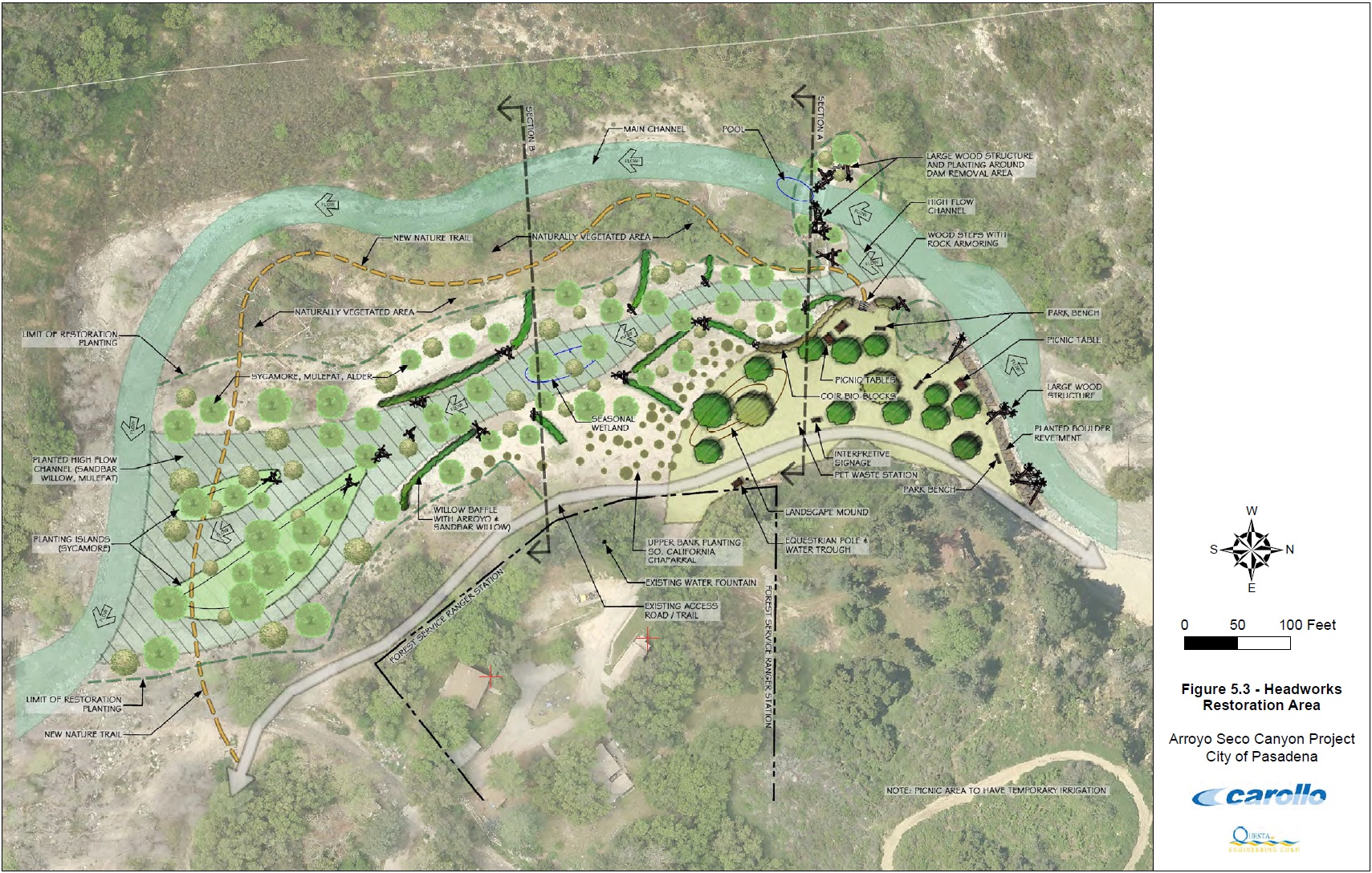
image: arroyoseco.org
(Click here to Zoom larger image)

image: Riverside County Flood Control

Here is an extremely interesting idea for slowing water down by means of a floodplain detour and allowing a healthier vegetative community which in turn allows for more effient water percolation while filtering it better at the same time. It also provides greater habitats for both wildlife and people. What struck me too when I first saw this architectural drawing from the Arroyo Seco Project for creating a wider floodplain aside from the actual narrow channel of the riverbed, was that it is in miniature what I described with regards the San Jacinto River Valley on it's historical grander scale and the 1980 flooding of the city of San Jacinto from the upstream breach of the levee which shut off the natural flow of the floodplain. The San Jacinto Valley should always have had been allowed a much wider channel from the very start of development as opposed to the present forced narrow corridor it has now shoved up against North Mountain where it is today. By their very flawed human nature this was never allowed when the area was originally settled because personal speculative economic fortunes were at stake. Then of course there was all that ignorance thingy and the fact that most didn't automatically care enough to consider finding out the truth of the matter we know as pros & cons of proceeding or not with a planned rearrangement of the landscape. In fact many of the housing & other commercial interests (which is really the motive behind re-channeling to facilitate Human economic interest which brings more tax revenues) in the floodplain areas should never have been allowed in the first place. While one may view from the ground what looks to be a large flood corridor as it exists presently today in some photographs, it's actually not capable for handling the often massive waterflow capacity which charges like Spain's running with the bulls chaos out of those mountain canyons when all it's side tributaries are firing on all pistons at once. I've posted a recent study in my references section at the bottom of this post which points out the problems regarding forcing Nature's hydrological components into narrow channels even when it seems to be for the greater economic economic and human safety considerations. It basically deals with the Missouri River and what the Lewis & Clark expedition actually saw when they explored new things like these Spaniards with their own American Empire building ambitions.

The other problem with Human rearranging of river courses by means of concrete channeling is that most of the water which falls as rain in Southern California is purposefully expedited downstream quicker and is lost forever into the Pacific Ocean. I found this to be true even when I lived in San Diego County. Even when it rained lightly in San Diego County's own inland empire, most of what falls ends up as asphalt street runoff and the Mission Dam area quite often will always look like it's at major flood stage, even when there are no heavy rains. I am most certain that way back in historical times, this region (El Cajon, Santee, Lakeside valleys) didn't always flood with massive amounts of runoff with almost every single rainstorm. Even when it did rain heavy, most of the healthy vegetated topography would have allowed more of the important water percolation or infiltration into the soils which is necessary for downstream water sustenance in riparian ecosystems during the dry season by means of various springsWater would still end up eventually into the Pacific Ocean anyway, but at a much later time frame and slower level of pace. Other system community members such as beavers and believe it or not bears would have contributed to the slowing down of water as it pursued it's ultimate path of least resistance goal to the Ocean by means of gravity and other physics. Look up most older historical topo maps, especially Thomas Bros and you'll find a common notation by means of symbols of the exact location of Springs. Many were named, but many others were not. Question is why ? Wasn't necessary, but Springs were more important to travelers in times past than today. They were the rest stops of the day. You should however know that most of these are now dried up, gone and long forgotten mostly by the cattlemen who used them. I know because in the surrounding Anza Valley area where I once lived for over two decades, I actually made a deliberate attempt to find each and every one of these on my old Thomas Guide which took a little over a decade. Most of the springs without names were fashioned into cattle water concrete and/or stone troughs from seeps other small water anomalies. Today these springs hold little importance to the modern day person and therefore omitted from all newer maps. Okay change of subject:
~~~~~~~~~~~~~~~~~~~~~~~~~~~~~~~~
Biomimetics and Hydraulic Redistribution
Image animation: DawsonLab

Okay, here I go again. Apparently I have to bring up the essentially important subject of hydraulic redistribution regarding the very foundational underground rooting network which allows everything above ground that we see and enjoy to become an ongoing perpetual  sustainable reality over countless lifetimes. This is even partially why I even created "Earth's Internet" in the first place, even though many of the subjects may seem boring to short modern day attention spans. Let's consider the illustration above for a moment. Let's pretend that this cartoon animation illustrates the huge old growth Cottonwood trees on the present normally dry sandy floor of the San Jacinto Valley floodplain. These deeper rooted old growth riparian ecosystem trees which could also include California Sycamores would have been efficient performers of that all important hydraulic descent even during dormancy, even as the #3 option in the graph illustrates. Such interesting mechanical phenomena would also have been present during drier times, maybe even prolonged macro-climate drought events where a sustained high water table untouched by any human concerns would have allowed the lush system to maintain itself. The challenge however in artificially rebuilding any type of vegetation ecosystem is education on exactly what type of  vegetation components act as the best Hydraulic redistribution mechanisms. I researched this for many years up in Anza when living within the predominantly Chaparral Plant Community up in Anza California. This actually helped in establishing pines and oaks in remote locations with little or no water available for conventional irrigation. While I found several candidates, Redshank or Ribbonwood [Adenostoma sparsifolium] and a close second by it's evil tough wildfire causing cousin Chamise or Greasewood [Adenostoma fasciculatum]. Kidding of course about the wildfire thingy, that's more about attitude and prejudice more than truth based on knowledge. In the riparian system it's easy, Cottonwoods, Sycamores, and in some cases within this region Mesquite trees. Some willows also may have value during temporary dry period years, but not always. Other trees for the San Jacinto system also may be Arizona Ash which has large populations on the valley floor as it emerges out of Bee Canyon along the Indian Creek water course and floodplain.
(Bit of a side note regarding White Alder (Alnus rhombifolia) in the San Jacinto River valley)
During the wetter years when both San Jacinto River and Bautista Creek ran all year, or even when it trickled by flood comparisons, White Alders flourished even in low regions of their valley floors where there were extremely hot temperatures. In Bautista Creek they were present even in the basin catchment behind the diversion dam. In the San Jacinto River they would often show up as far as the river flowed towards Mystic Lake. If this happened in the 1980s, then they were present back when the Spaniards came through. These trees are almost always associated with continual moisture & cooler climate conditions and that's true that they do thrive in such situations. However in there are other unique instances given surface water presence, these not so deeply rooted trees can even become  successful anywhere in the hot valleys below. For example, when during the same 1980s flooding event period when Tahquitz Creek and other Palm Springs water courses flowed year long into the main channel of Whitewater River down the greater Coachella Valley, these trees sprouted all along the water courses here and there. Even when temps topped well over 100+ degrees Fahrenheit (40+ C). I know because I was amazed when I went on my weekly visits to one of my clients at Mac Magruder Chevolet whose property sets next to the creek on Hwy 111 in downtown Palm Springs. The problem comes when the surface water goes away. For a short while they may flourish and sustain themselves from below ground water, but they eventually fry in the intense heat even when that goes further deeper into the soil. They are not deeply rooted like Cottonwood or Sycamore trees. Hence they would make a lousy candidate for establishing trees with great hydraulics potential. However, from a biomimcry point of view, if one needs to stabilize an actual streambed with permanently running water, they would be the best at holding tightly together the streambed. Only then world the shallower rooted Alder be your best choice. In Idyllwild along Strawberry Creek when water levels were low, you could see why the dominance of the White Alders was a good thing. These shallow rooted trees weave their shallow surface root systems in and around boulders and large cobblestone river rocks so tightly and close together, not even large massive floods seem to be able to budge anything about the main bed. At the same time, this physical feature also makes them a terrible candidate for lawn trees as the constant mowing shaves off the tops of these lateral roots create a pattern of burn mark outlines in the grass as the roots grow larger with age and scaring is horrible as well. But once again, these are shallow roots and need permanent water flow. Here in cool wet Scandinavia they grow on mountainsides far away from Creeks and therefore in no need of a water course.

Given these facts, hydraulic redistributing from the deepest roots of old growth Cottonwoods and Sycamores would have played the most important role in sustaining the entire system even during the drier water table fluctuating periods. The main problem I find when it actually comes to the subject of hydraulic redistribution is that you rarely if ever hear it ever discussed. Other than a handful of not well known intellectually written pieces often times behind some ridiculous Paywall, does anyone really hear about this info anywhere being discussed ? No and they should. This is where such basic fundamentals on any and all plants prior to engineering an ecosystem based on the discipline behind Biomimcry which in this case simply means having knowledge of what each riparian component is and what it accomplishes within that system is imperative and where true architectural design becomes a real success. But I'll go further. Those who sign up as volunteers for many of these land or habitat restoration projects should be required to go through an education program where they actually understand the underground system mechanisms of the above ground paradise they are attempting to save. But lets go even further, the school systems should have such subjects have as part of their science programs which would include these same basic fundamentals in regards how Earth's ecosystems work, function together and maintain over the long haul. Dump the old failed dogma of "Survival of the Fittest" and replace it with "Survival of the Mutually Cooperative". The biggest road block to all of this is these suggestions while many will agree upon, they are simply far to logical to be implemented into any government run program irrespective of the country. Sadly the world's authority just doesn't work that way under the present system. With the present disastrous water shortages in all of California, better uses of major floodplains for percolation purposes should be looked at more closely. This may even mean relocating folks, but that would be another major headache issue. Of course, then there is also the issue with regards street contamination of water which might restrict drinking water quality. At the very least, public parks and other utility usage needs could be satisfied. Take a look at the two comparable photos below of where the present San Jacinto River Channel runs close to the western end of Soboba Hot Springs Resort. 

Image: Mojave Jones (Panoramio)
Notice the main channel to the left hand side which has been forced up against North Mountain's foothills and the overflow flood channel on the right. Also notice the island of native vegetation in the middle which separates them  them ? Below now, notice the flood overflow on the right hand side becomes more apparent when full of excessive water overflow is at flooding stage. When rivers and streams are forced against the natural physical demands of how  water flow should proceed, the narrower channel creates stronger force which allows scouring and deep erosion to take place. Especially when vegetation is removed. If vegetation is still present, then it won't be for long. Keep in mind in regards to the rain photo below, this is not truly a real flood event of times past like the 1980s. This would be normal winter year, although even that seems to be changing with the climate disruption.

Image: Mojave Jones (Panoramio)
Again as you can observe in the above photo, this is now wintertime. The riparian trees are all dormant as per lack of any leaves in the photograph. Still, if there were a much larger floodplain allowed alongside the main channel with a greater vegetation content, the water speed would be radically reduced. Studies show that forced narrow channels cut, gouge and scour the physical water course and that should not be the goal in water transport which is all that is considered. No one should ever want an L.A. River Concrete monster on steroids in their own backyard. That is never an answer or option. A more natural approach would also allow for far better water infiltration and percolation into the valley's water table aquifer further facilitated by the phenomena of hydraulic descent even by dormant trees. If you view the map image below, you will notice that there are some attempts and plans to take land development use off the table and allow for the natural buffering. 

Regional Conservation Authority - Western Riverside County
"On June 24, 2009, the RCA acquired the San Jacinto River Ranchos property, totaling approximately 73.29 acres. This property is located within the San Jacinto Valley Area Plan, Subunit 3 - Upper San Jacinto River/Bautista Creek area. The property also falls within Rough Step Unit 2. The acquisition of the property is expected to help conserve important biological resources including arroyo toad, mountain yellow-legged frog, burrowing owl, Cooper's hawk, least Bell's vireo, southwestern willow flycatcher, yellow warbler, bobcat, Los Angeles pocket mouse, mountain lion, western pond turtle and slender-horned spine flower. The subject property will assist in providing a linkage for wildlife movement along the San Jacinto River and is adjacent to existing PQP conserved land to the north and east of the property. On July 28, 2009, the RCA also acquired the Meadows at Lone Cone property, totaling approximately 67.61 acres. The Meadows at Lone Cone property is immediately southeast and adjacent to the San Jacinto River Ranchos property and contains similar biological resources."
Regional Western Conservation Authority, Riverside County 
~~~~~~~~~~~~~~~~~~~~~~~~~~~~~~~
Now, Getting down to the Bear facts as I see them

illustration: Soren Hendrich

image: Mike Cavaroc 2010
This great illustration above reveals the importance of Bears to riparian woodland systems. Black bears are omnivores with their diets varying greatly depending on season and location. That seems to be universal with most bears, although we think of Grizzlies as more meat eater. Hollywood *sigh* They typically live in largely forested areas like those of the San Bernardino National Forests, but most likely they would have left those forests in search of food in valleys below perhaps in the wintertime when they were clearly abundant and observed and noted by the Spanish Explorer Journals. Notice in that illustration above the watershed ecosystem to the left has more bears, old logs and debris pile ups associated up and down the riverbed which allows for more slow water movement and meandering ? Also the one on the right has less debris and logs in the stream or riverbed in the lack of large presence of bears ? Bears have an incredible nose for food sources and can scour through a forest floors opening up the understory. As the photo above illustrates, the Bears foraging around dead logs and perhaps still standing dead trees looking for bark beetle grubs. In so doing, they further degrade the dry dead vegetation with their powerful tools which allows further more efficient decomposing which allows nutrients into the Earth only to be returned to the other living vegetation. And let's no forget the health benefits of 
Earth being a much crappier place at one time

Image: Wildfire Programs
The illustration here of a man made cleanup in a riparian understory in the  photograph is important for a number of reasons. First, in historical times winter rainy season flooding had the ability to remove and redistribute dead materials from the riparian forested understories. These floods also would have flattened grasses and other small plants to the forest floor where many microbial components could further break them down. Much the way heavy snows do in high elevations. Newer small plants come in spring and refresh the ground under the trees and the process starts all over again. This leaves bears, beavers and other animals to further rummage and redistribute the material on the ground as they need or see fit. As far as bears, they could deal with even dead standing trees by knocking these over, sometimes into the water courses themselves while foraging for grubs. Beaver could more easily acquire smaller dead branches from such bear fallen trees to utilize as construction materials inserted into the dam or other lodge projects, thus contributing to water debris piles or jams we saw in the other previous illustration above which provided the protective nursery habitat for smaller fish. The other main point to consider here is wildfire. Modern weedy vegetation chocked streams and riverbeds in Southern California are no longer a natural wet impediment to an advancing wildfire. Often times the bull doze their way through a riparian area with massive amounts of dead material ripe for wildfire consumption. Another reason better water management is necessary. The cost of mismanagement because of ignorance has been much higher in the long run.


image: logs and trees
I've selected this image here on the left to illustrate the benefits of what various logs piles and jams in just the right locations can do for a river or stream. This animation is actually taken from a website dealing with fishing for which I have linked to at the bottom of this post in the references section. It illustrates where fish prefer to lay low and hide. When I visited family in eastern Iowa in the summer months (late 60s early 70s), I'd go fishing just about everywhere and those woody debris like branches and log jams piled up in a sort of birds or rats nest were perfect places to drop a line with bait. In main river channels with large log jams, sometimes containing whole trees, it was the sucker type fishes which preferred these locations. We'd always throw sweet corn in a open hole within the jam which would attract the Red or White Horse Suckers. Put sweet corn on a hook and you'd have a catch. These fish fed on the algae growing on the logs inside the river, hence the sucking sounds we'd hear were Suckers scavenging algae on tree branches underwater. Given a similar diet with the Santa Ana Sucker who forage gravel, small rocks and boulders for the same thing, it could well be that such fish could have existed in the San Jacinto River if the channel were opened at times of higher than normal rainfall to the Santa Ana, whether or not they really did is another one of those things we'll simply have to ponder. They prefer a clear clean water, something the San Jacinto River does have when it has continual flow after winter's flood stage is finished. In any event, the speculation is fun. Here are is a link which illustrates the necessary pools for fish as provided by logs:
http://blog.nature.org/science/files/2013/08/dead-wood-twelvemile.jpg
image: Gordon Robinson
Of course then there is that nagging question that keeps haunting me, were there ever Beaver in the San Jacinto River Valley ? You know the Beaver would have flourish if they were around such shallow reedy pools, marshes and slower movement of water throughout the year would have suited their purposes wonderfully. There are no references to the Explorers  seeing and/or documenting beaver here in the San Jacinto valley, but references to them seeing native women wearing fine clothes made of Beaver skins around San Luis Obispo and one mention is of Anza receiving 30 beaver skins as a gift in San Luis Obispo by a Priest from there are recorded. If beaver were there at San Luis Obispo, then more than likely other areas of Southern California would have had them present. At best I would say any beaver in the San Jacinto Valley might be related to the Sonoran Beaver which is throughout the Colorado River Valley to Baja and Imperial Valley. Any connections to the coast would have come by way of San Felipe Creek and filtered up through the mountains. In any event, Beaver could have flourished in the slower moving waterways in and around the San Jacinto Valley areas. Also such Beaver populations could more easily become efficiently eradicated in Southern California as this was one of the main targets of human growth and agricultural needs. There is simply not enough water and what exists there is not enough even for the existence of life now as evidenced by the fact that multiple strategies have been devised to import water from other areas. The rainfall totals are far lower than elsewhere would not have supported both natural and artificial systems together.

Riverside Flood Control

"Streams the way Nature intended them to be"
Any riparian ecosystem should have a great dynamic of biodiversity in the form of multiple plant species, large & small animals, birds, fish, amphibians, and microorganism communities along with all the non-living elements such as geography, the right water chemistry, all interacting as a single functional unit. Something about the photo here of University Channel makes me think of the Harris Ranch Beef website. Can you imagine if Harris Ranch Corp had a Industrial Irrigation Construction website, what their company slogan would say, "Streams the way Nature intended them to be" ? The problem I see with most modern changes made to any ecosystem's character are the changes in it's various community members and changes in physical contexts, sometimes crossing a threshold of tolerance within the system that results in its inability to rehab back into its previous natural form. Austrian Forester Viktor Schauberger even warned about this deliberate attempt at ignoring the long term consequences in favour of the immediate financial gains when it came to re-channel natural river systems with artificial ones. The results from human intervention to force things into these sterile lifeless channels allows for the demands to be met for their commercial interests. One by one when various natural mechanical components are removed, not really noticeable at first (just like any sickness or other cancerous ailment), until finally there is a sudden crash in it's life sustaining functions. An interesting characteristic that I observed about the San Jacinto and Hemet Valleys were the difference in soil textures and types. The eastern end of the valley where the Bautista Canyon Creek and San Jacinto River canyons emerged out onto the valley floor, the materials were much more like those in the top photo of this post with large boulders and cobble stones gradually giving way to a sandy soil riverbed. 

Hydrology & River Sciences
However, the western part of the valley has much more refined soil sediment or even clay-like qualities about it which is the main reasons for the historical presence of Vernal Pools and other small lakes that often remained for many months into the drier season. Surface waters in the form of rivers, lakes and wetlands are the most readily apparent component of the hydrologic cycle, but in most areas of S.J. Valley there is a strong interaction between surface flows and groundwater. The water table is not that deep in many places, which should be great news for any landscaping planner if he knows what he is doing. This interaction in the past would have been apparent when surface flows in perennial streams continued long after the rainy season's precipitation or snowmelt runoffs from the high country. Later the Monsoonal summer events would have had a moderating effect. Groundwater is recharged by infiltration from precipitation and surface flow and, depending on the depth of the water table and subsurface geology, groundwater may be subsequently released as surface flow. The release of groundwater to surface water provides most of the base flow for many of the San Jacinto River's contributing streams (like Portrero, Poppet, etc) through periods of no precipitation, or during winter when precipitation may be locked up in the form of snow.  It should also be noted that the mass of forested vegetation, marshes and backwater lagoons written about by these Spanish explorers also would have blocked out the larger heavier sedimentary rocky materials, but would have allowed the finer nutrient richer particles to filter on through which provided the bottom seal for many of the Vernal Pools and lakes on the western side of the Valley. Mind you, we're talking about a period of 1000s of years for all of this to continue uninterrupted. Yet, it took a little over 100+ years with so-called increased brain power infused with modern enlightenment to ruin it all today.

I'll close here as I can say what more I need to say in my main and final post on the Anza Expedition post next week. Below you may want to view and enjoy bears love of water in riparian habitats. Try and imagine this scene in numerous dead riparian regions which either exist in fraction or completely altogether. As always, please make practical application of things read and observed about Nature in your own garden and urban landscape.


"All parts of the fabrication and recycling process are cleverly linked and powered largely by water. The destruction of ocean crust via subduction leads to the formation of continental crust through water-facilitated melting. The destruction of continental crust via water-driven erosion ultimately replenishes the mantle for the next round of ocean crust production. Efficient, sustainable, robust, and elegant, the system would win top honors in an industrial design competition." [emphasis mine] 
 The above quote is from Geology Prof Marcia Bornjerud who commented on the tectonic system in her book, "Reading the Rocks". The first and last sentences struck me as beautifully descriptive of a healthy riparian ecosystem when viewed as a well oiled machine. Of course I know she's talking about the Earth's Tectonic plate mechanisms, but still ? She wrote a wonderful piece a few years back on Fracking and Strip Mining which I found interesting:
A Change We Didn’t See Coming: Hydraulic Fracturing and Sand Mining in Wisconsin 
~~~~~~~~~~~~~~~~~~~~~~~~~~~~~~~~
Interesting Reading References:
California Chaparral Institute: "The Tunnels of Rancho Penasquitos"
FlickRiver: Hemet-San Jacinto Valley
Where to Fish in a River
Here is an article I remember reading several years back from the Washington University of St. Louis about how different the Missouri River is presently compared to when Lewis and Clark first journeyed on it. It was much wider then and less flood prone because of greater width. The river now is far narrower because of the work done by Army Corps of Engineers and more subject to floods than it was back in history. Go figure!
Lewis and Clark data show a different Missouri River 
Here is a further take on some geographical mechanisms which can shape, create, tear down and rebuild a natural water course and it's the example of the two water flow channels of Bautista Creek mention by Fray Pedro Font which the majority of folks presently living in the city of eastern Hemet know nothing about:
Old Bautista Creek Channel East and West side
This is a further link to a piece I wrote recently about Juan Bautista de Anza's description from his diary of when he approached the Santa Ana River valley looking just like the the San Jacinto Valley he just traveled from. Today there is no such comparison, so I provided a reverse description to illustrate what San Jacinto Valley looked like in times past. Had I not done this, there is no other way to explain it to you. 
 http://creating-a-new-earth.blogspot.se/2014/05/the-san-jacinto-river-valley-that-juan.html
Finally, this mostly has my own personal speculation as to possible historic connections of waterways to the Santa Ana River on a more permanent basis which would have allowed various other native fishes to exist, even if at times temporarily isolated:
San Jacinto River Wildlife Refuge & the wetlands potential beyond to Corona 


Monday, May 5, 2014

San Jacinto River Wildlife Refuge & the wetlands potential beyond to Corona

Mystic Lake, Lake Elsinore and Temescal Canyon

Image: Tung Tran

San Jacinto Wildlife Reuge

This is a favourite scenic spot for many who come to visit the San Jacinto Wildlife Refuge. Those hills in the background are what is believed to be the hills on the western side of the Mystic Lake where the Anza Expedition camped on both back to back expeditions. It certainly would be the easiest region to cross over the San Jacinto River as the waters flatten out into shallow pools just down stream of  Mystic Lake itself which would be the largest and deepest. The current of the river also would have been far less swift at this location. While the area does have a few pockets of riparian forest woodlands, it is mostly sedges, rushes, cattails and other tall tule grasses. Below is a closer up view of the same image above.

Image: SoCalHunt Gear

http://socalhunt.wordpress.com/2010/12/
Believe it or not, the area is supported by Duck Hunting Clubs and is kept recharged through agreements with the water agencies for reclaimed water, otherwise these also would disappear during the drier times which have obviously become a more frequent feature resulting from climate change.
Image: Jeff Sullivan
It could be said that such large depressions of dry lake beds around the Lakeview area could also be considered giant vernal pools in many respects as many of the same plants and amphibians thrive in such locations as these Goldfields always do when the waters begin to dry up. BTW, below is a link to western Riverside County wetlands creatures which are dependent on Vernal Pools for their existence:
Western Riverside County  Multiple Species Habitat Conservation Plan (MSHCP)  Biological Monitoring Program 
Vernal Pool Survey Report 2010 

Photo by Mike Wilson

Region where San Jacinto River merges with Mystic Lake
just west of Highway 79 and north of Lakeview California


Photo Mine

Major construction of San Jacinto River
bridge on Hwy 79 in Riverside County 1994
This photograph of the San Jacinto River flowing into Mystic Lake was take by Mike Wilson during the last heavier rainy season the inland empire has experienced in 2005. The predominantly dense Cottonwood Riparian forests & bordering marshlands would have extended all the way to just a little beyond present day Hwy 79 Bridge where it crosses over the San Jacinto River today. This very highway was closed for almost an entire year in the early 1980s before there was any bridge built. Mostly it was a mile long dip through a floodplain wash. That winter's rains washed out the Highway 79 or Sanderson Ave and water flowed over it for most of the year. While the photo above has the appearance of a straight river course to Mystic Lake (lake of San Antonio Bucareli), the difficulty of traveling from Park Hill encampment to this lake region was described by the Priest Francisco Garcès and the others as having great difficulty because of the bogey soil and reedy pool marshes on both sides of the river's Cottonwood Forests which demanded detours here and there. Even the surrounding small hills were described as having miry soil. It illustrates the wetness of the climate and abundance of a extreme high water table, which resulted from no one for 1000s of years previously never tapping into the area's groundwater for human purposes: 
Priest Francisco Garcès (March 19, 1775 1st expedition)
"Winding around by a very miry road, we came to a hill, [Footnote 93] having traveled about four and a half leagues almost to the northwest but with many windings, because the hills as well as the plains are so boggy. The groves are thickly grown with grass, one species of which bears a seed very much like rye."
Juan Bautista de Anza (March 19, 1775 1st expedition)
"At eight o'clock in the morning we took up the march down the valley toward the northwest. Its amenity and the beauty of its trees continued for three leagues, after which the trees came to an end but the amenity continued. We followed it for three more leagues, till we came to the banks of a large and pleasing lake" 
Fray Pedro Font  (December 30, 1775 2nd expedition)
"The land is very soft and when it rains it is somewhat miry. Here and there in the valley there are some hills with rocks and shrubby growths but without any trees, though the soil of the hills is soft like that of the valley. In all the valley there are no other trees than the cottonwoods of the river bottoms. In the high and snow-covered sierras one sees pines and live oaks, and it may be that on their skirts and in their canyons they may have other trees, because they are very moist."


Nature.org

San Jacinto Wildlife Refuge


Juan Bautista de Anza (March 19, 1775 1st expedition)
"We followed it for three more leagues, till we came to the banks of a large and pleasing lake, [Footnote 116] several leagues in circumference and as full of white geese as of water, they being so numerous that it looked like a large, white grove."
Priest Francisco Garcès (March 18, 1775 1st expedition)
"We saw a countless multitude of white geese like those which I saw at Agua Amarilla."
Fray Pedro Font (December 30, 1775 2nd expedition)
"In the valley there is a large lake formed by the San Joseph River, and by other arroyos which come from various springs and brooks in the sierras roundabout and which have no other outlet. Therefore, according to the signs, this lake rises very greatly during the rainy season. In it there are vast numbers of geese which at a distance are seen in large white flocks."
Image: SoCal Hunt Files
Word of note on some of the Hunting Clubs. There has been controversy in the past with the Ramona Duck Club regarding grading with heavy equipment:
SAN JACINTO: Grading prompts wildlife concerns (Sept 2011)
SAN JACINTO: Army Corps probes wetlands area grading
But again if anything could be said about their efforts, they have kept certain regions alive with wetlands upkeep and water agreements with reclamation agencies.
Image: Press Enterprise

Image Wiki
What can I say, one of the most impressive things noted beside the abundance of water, wildflowers and riparian woodland plants were the massive scale of millions of waterfowl, most notably Geese. To bad that often times this ancient lake bed area is a dry mud hole. The year 2005 appears to be the last good year for water availability. Though I'll check back there again this coming late May 2014. The S.J. Wildlife Refuge itself however is maintained by agreements between some of the Duck Hunting & other wildlife organizations for reclaimed water recharging. While those Geese observed by the Anza expedition were certainly on a grand scale at the Mystic Lake location, they and other aquatic birds would have been almost everywhere throughout this region of flatland vernal pool country at this time of year. Of mild interesting note, earlier this year the Riverside County Newspaper had this article about the return of wetlands Geese back to these regions:
HEMET: Canada geese may flock from Temecula, Menifee
 ~~~~~~~~~~~~~~~~~~~~~~~~~~~~
Image: Rancho Vista Nuevo Hills 

Looking north from the hills above Lakeview & Neuvo area back towards Mystic Lake and the San Jacinto Wildlife Refuge Area. This photo is actually from a real estate development company.


Image: Riverside Co Flood Control
Okay, now let's turn in the opposite direction towards the south where the San Jacinto River itself does continue it's flow, which is in the opposite direction that the Anza Expedition did not follow. We'll head down stream and take in some historical facts there from Nuevo and beyond. The river's course is now more channeled here to allow farmers to cultivate the landscape on both sides of it's banks, but that same type of flat valley floor geography extends further south to just the opening in the low hill passes before entering Canyon Lake and then drops steeply into Lake Elsinore. There is a great map of the region by the same group attempting to save precious habitat for the endangered Vernalpool Pincushionplant Navarretia fossalis plant, among other organisms, which need vernal pool environments to exist. Unfortunately these flatland areas are also prime real estate development properties and there are the predictable conflicts by the usual suspects. This area also has it's own history of flooding as the photo at the top right shows near where the river flows under present day Interstate 215 & old Hwy 395 (now Case Rd) around the year of 1927. Most I-215 travelers driving over the bridge where the narrow channel of the once mighty San Jacinto River is presently, hardly give it a notice unless they are lucky enough to see the sign marking it's existence. Even the earliest Railroad which originally went from present day Perris to Oceanside went down what is now known as Railroad Canyon was eventually relocated through the Temescal Canyon route from Corona because of frequent expensive washouts to the Canyon Lake area. But even that old line is now abandoned because of similar flooding washouts in the Santa Margarita River canyon. Below is that wetlands protection area map which runs from S.J. Wildlife Refuge all the way to Canyon Lake.


Map image: EPA

One of the main things I was always curious about when I traveled Hwy 395 and later Interstate 215, was if the San Jacinto River could have at one time back in history maintained some permanency in it's flow even if at times it was nothing more than a mere stream surrounded on both sides with backwater Vernal Pools during the drier periods ? Consider for a moment, there were no upstream  dams and for countless centuries a water table clearly untapped for 1000s of years. Mature old growth riparian forested areas scattered along it's banks here and there, perhaps all the way to Corona California where it would have met the Santa Ana River floodplains. Most maps never show the San Jacinto River as flowing beyond Lake Elsinore, but clearly there always was an outlet where the landscape topography is at it's lowest point through the city center of Elsinore itself and flowed mostly along what is known today as Collier Avenue, but more on that later.


Image: San Jacinto & Lake Elsinore Watershed Authority


This area above is the often favourite area for photographers to stop at a couple of points on the Route 74 also known as the Ortega Highway. You can see the modern version of the lake where the historical southern portion is no longer allowed to flood. You can also see the channelized portion where the San Jacinto River flow inlet extends into the lake near the top middle of this lake photo. Interestingly, if the snow capped Ortega Mountains were a more common occurrence back centuries ago as in this 2008 photograph, then certainly this would have helped to maintain river channel flow from Elsinore to Corona in what is known today as Temescal Creek. Certainly anything was possible, especially considering the second journey of the Anza Expedition where they had a month earlier experienced a major blizzard right next to the Salton Sea. Clearly heavy snowfall would have been more common up in the Ortega Mountains. It could well have been possible for a more maintainable flow of the San Jacinto River with numerous downstream tributaries which could have extended all the way to Corona connecting at the Santa Ana River. In any event this would prove an excellent corridor route for numerous aquatic creatures which I will get to later.


Press Enterprise
I remember such scenes in the 1980s and middle 1990s when rain swollen San Jacinto River finally made it's way down the Railroad Canyon to Lake Elsinore and once again flooded the southern part of Lake Elsinore Airport & Skydiving facilities on the south flood plains. Almost made it to De Jong's Cash & Carry Dairy there on Corydon Road. The scene now however has changed. No longer will the lake be allowed to completely fill up as in times past. The south floodplain will be forever allowed to remain untouched by future flood waters thanks to the government efforts at building a large series of levees forcing the excess lake water through an improve concrete channeled outflow through downtown Lake Elsinore. You should also take note that water which once naturally channeled into the lake from the south by various mountain tributaries has been rerouted towards the direction of a Temecula direction to the south. This allows for less danger of even mild flooding on the south flood plain. The photo above is the San Jacinto River which flows through Railroad Canyon after coming through the Canyon Lake spillway upstream. As I stated previously, this San Jacinto River officially has never been shown on amps to flow beyond Lake Elsinore, but clearly there always has been an outflow channel which has mostly been choked with cattails, reeds and other tule grasses, made it's way along Collier Avenue and even the old Railroad right-of-way followed right along this wetlands strip, much of which remains and is still protected. At times of high water flooding in Lake Elsinore when water did flow through the city, Riverside drive which is also part of Hwy 74 which comes from Perris California has been closed for months as floodwaters impossible to contain inundated the wetlands portion of this roadway. There is a technicality which lists on maps the stream or river outflow from Lake Elsinore to Corona as Temescal Creek. All along the way through this canyon there are also tributaries which sustain the creek. 


Map image: Wikipedia
A much deeper detailed image of the entire Santa Ana River Drainage basin is here below which shows Temescal Creek from Lake Elsinore through Temescal Canyon to Corona and Santa Ana River. Again, notice the other side stream channel contributions. You should also recognize the region near the Pomoma-Ontario area  and the San Antonio Creek where Anza, Garcès and Font made mention of many bears down around this valley floor riparian woodlands. Hmmm, what were those bears doing there, perhaps fishing ? And if so, for what were they fishing for ?


Image: Wiki - Temescal Creek
Here is an extremely interesting and fun interactive wetlands map just released on May 4th 2014 by the U.S. Fish & Wildlife Service of the entire North American region which lists all various forms of documented wetlands habitat types of ecosystems which need protecting of what is left. There are numerous kool interactive tools to use within this map. By all means link the link below and bookmark it for future reference:
 National Wetlands Inventory
http://www.fws.gov/wetlands/Data/Mapper.html
~~~~~~~~~~~~~~~~~~~~~~~~~~~~~~~~
Temescal Canyon & Historical Possibilities
Image: Riverside County Floodcontrol
Sadly like everywhere else in Southern California the area of Temescal Canyon has been the target of major developers for more bedroom districts. The photo below illustrates this fact where Interstate 15 runs through the middle of this canyon allowing for easy access for future commercial development. Some readers may even remember when this area had Hwy 71 running through it all the way from Temecula. Historically the only prior human usage by the pioneering Europeans was the Citrus industry. Still, one wonders about the potential for a more permanently flowing river channel through here which would have allowed for newer upstream native fish habitats to exist. This has also one of my interests for this riparian river system since the 1970s. The area of course does have it's own history of flooding at times such as the storm of February 1969 flooding on Temescal Creek in Corona, Magnolia Avenue and the Pacific Electric Railroad tracks as the photo above reveals. Of course more concrete channeling took care of that problem.

 Sycamore Creek, Temescal Valley, Riverside County, CA


Add caption
There are number of things I have always wondered about with regards possible native fish species in Southern California. First off there really aren't a lot of them and if there are, they are mostly uncommon in most of their former traditional waterways. After becoming interested in many things Arizona and discovering back in the 1970s that at one time there were some 35 native Arizona fish species, I just knew there had to be something about possible native fish in San Diego County where I grew up. Of course there are fish, but mostly nonnative introduced species from the eastern USA. Unfortunately there was very little information at the time. It seemed only logical though that if the dry deserts of the southwest could contain several native varieties of fish in numerous isolated locations, then there must be something to be found in San Diego and other locations of SoCal which have more permanent waterway corridors. About the only thing I found was a native Steelhead Trout in SoCal which seemed to closely resemble a Salmon in appearance and nature of living in both the ocean and streams for spawning purposes. The fish example pictured above here is called the Santa Ana Sucker which still exists today in the Santa Ana River drainage. If the climate and high water table conditions existed without interference from human development, it could logically stand to reason that such fish could have also been common even in the San Jacinto River system as it has other accessible systems along the Santa Ana drainage. While the literature suggests the possible presence of the Trout & Sucker in Temescal Creek system, they are dogmatic in their insistence that the Lake Elsinore basin was a major barrier to their possible presence further upstream. But I call this mere speculation based on what we only know have recorded since the Europeans first arrived and started corrupting the once pristine environment. Worrying about conservation and the environment were not exactly ingrained into the culture back then who exploited the natural resources in the race to see who became the wealthiest. But there clearly are some clues.


The Spanish explorers made no mention what so ever of any kind of fish being found in the San Jacinto River Valley. But they had previously made mention of finding fish as they traveled through western Arizona along  the Gila River. Although they didn't spend much time in the San Jacinto River Valley, this doesn't necessarily mean there were none to be found there. If all the main components of a massive wetlands system which allowed for a self-sustaining uninterrupted river bed to Lake Elsinore, would it not be more than likely possible then that there be a continued connection through the Alberhill area down into the Temescal watershed system towards the confluence with the Santa Ana River to clearly have been possible ? Another reason I personally have for believing in possible fish migration connections are two other native fish I have personally stumbled upon in the early 1980s in the south and middle forks of the San Jacinto River Canyons. Take a look at the picture I have used before of the Middle or Main channel of the San Jacinto River from a Hwy 74 vantage point heading up to Idyllwild.


California Route 74 @ AARoads

San Jacinto River Main River Channel


image: Warwick Sloss
This part of the river above which I call the main canyon and back up into the South Fork Canyon branch of the San Jacinto River which would be to the left and out of view in this photograph is an interesting area where two native fish do live or at least did in the early 1980s. This view during the 1980s almost always ran with rushing crystal clear water. Not only the South fork, but also Cold Creek and Strawberry Creeks which would be up canyon from this photo also contributed. Interestingly enough, both South Fork and Strawberry Creek have diversion check dams fitted with a Coanda Screen to block any debris from blocking any water being siphoned off for infusion of water into the irrigation aqueduct which flows alongside Hwy 74 to southeastern Hemet Valley. In that exact spot in the above photo and further west I use to fish for the wild German Brown Trout which was forced from South Fork Canyon. But oddly enough I found several pools everywhere which teamed with the Three-Spined Sticklebacks (Gasterosteus aculeatus) which you see pictured above right. Most of the pools I found were back up at the mouth of the lower end of South Fork Canyon of the San Jacinto River. But I was surprised because the first thing that came to mind is they were the commonly released Mosquito Fish (Gambusia affinis), but these were more torpedo shaped. Actually there have been studies done with these little native fish and another which I saw which I later found out was the Arroyo Chub (Gila orcuttii). I later did find out that both of these fish are associated with the San Jacinto River ecosystem. Below here is a quote from one of the studies done by one of the researchers from UCR William Walton:
"(Gasterosteus aculeatus) L. Sticklebacks were collected by  dip net in the San Jacinto River near Cranston Station in the San Bernadino National Forest (Riverside County)"
(source)

photo: Mine
This image to the right is the irrigation flume which draws what water there is from upstream diversion dam sources. This exact spot is directly across from the Cranston Ranger Station mentioned in the research article where the collected both Sticklebacks and Arroyo Chubs which were experimented with at the San Jacinto Reclamation ponds over there off of Sanderson Avenue (Hwy 79) just south of the Ramona Expressway. At the very least I am glad to find other verification than just my word for the sighting. At this very irrigation flume valve gate my friends and I have actually found in the past Brown Trout lying on the side of the ditch as if they were trying to somehow escape the flume and make it back to the main river channel. So I would imagine the other fish from time to time get caught up in this canal flume and end up in what is now known as Little Lake, previously Anglers Lake.
photo: Mine
If I were to guess at the location of the place where fish collection was done, I'd say it was further upstream just past Cranston Station at the bridge which crosses over the Hwy 74 to Idyllwild, but Cranston would be the closest reference. There are pools there which I have never seen go dry. One other important feature which interests me as far as river maintenance and sustainability, and that would be Beavers. Yes, in the upper more forested parts of South Fork Canyon there were always beaver dam, but I never have known or heard of them moving further down river anywhere in the San Jacinto Valley or the wildlife refuge at all. The best way for getting back up in there quicker would be to drive up the mountains to the South Fork hiking trail turnout at the CalTrans gravel bunkers. Years back there was one large old dam and some small ones upstream holding back some stagnant pools during drier times. The large one was a bit broken up, but you could clearly see the sharp teeth marks at the end of the smaller logs and branches. I'd be curious as to their condition now during these years of drought and climate change. No mention in the journals of any Beaver either and I looked long and hard even in the Spanish journals by other writers on the expedition. Still, such a riparian river system which I believe would have run all year long, even slowly during dry times would have at least had the connections enough to provide habitat for bigger fish of the Santa Ana. Unfortunately we'll never really know the true condition of the San Jacinto River Valley, but it's fascinating to envision Bears fishing along the river in Spring for Steelhead Trout making their their way to and from the west coast. The only thing that can be done now is develop mere isolated token Parks along the river course to preserve and give folks an idea of what the area once looked like. The reclamation water has other pollution issues for wildlife and I just don't have the heart to report what happened with the Stickleback studies. Hopefully before leaving here I finish up with my main article which I probably should have done first to begin with. Just to much to say about what I've experienced over 30+ years I guess. BTW, I'll also finish the part II of my Beaver series in Riverside County, but I want to actually take photos of known areas by me.

Imaage - Wikimedia
Can anyone else picture or visualize in your mind's eye the San Jacinto River Valley floodplains with Grizzly Bears fishing for Southern California Steelhead Trout as they make their way east  to the South, Middle and North Fork Canyons to spawn ? Well I certainly can!
~~~~~~~~~~~~~~~~~~~~~~~~~~~~~~~~~
Further Reading References of Interesting
Swimming Upstream: "Restoring the Rivers and Streams of Coastal Southern California for Southern Steelhead and other Fishes
California Fish Species
Steelhead/rainbow trout resources of Orange County
Inland Empire Waterkeepers
There are seven species of fish that are endemic to the Santa Ana River, but only three are found today: 
Santa Ana River Native Fish