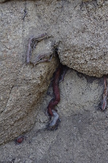
"Aug. 24, 1977: Flooded cotton gin on Dogwood Road in Brawley inundated by flood waters following heavy rains"
Los Angeles Times
 |
| Image from Los Angeles Times 1977 |
The image above is pertinent to this subject. The storm which hit in Imperial Valley in 1977 was Tropical Storm Doreen.. It dumped a massive amount of water. What's important is that the previous year of 1976 the area was hit by Hurricane Kathleen which also downgraded to a tropical storm, but packed with massive amounts of moisture. Is there a connection which later triggered Doreen ??? I think there is and it's happened before.Update: 2022 & 2023 - Hurricanes Kay & Hillary
Both satellite tracking images below are of Tropical Storm Kay in 2022 and the following year 2023 image tracking of Tropical Storm Hilary. The first one Kay was the stronger and first storm and the 2nd storm Hilary was significant, but not as strong as Kay. Storm Kay was so intense that Interstate 8 was closed in Meyers Creek area due to landslides and the old SD&AE railroad tracks were washed out on the alluvial fan at Ocotillo California. This pattern is identical to the Storms Kathleen (1976) & Doreen (1977) with Doreen being the lesser although still significant. Now back to main article.
There is a new term known as"Brown Oceans" and I'll provide it's definition below as it beautifully relates to this post's topic. So check out the link below and read about this effect on increased rainfall related to wet soil."What is the brown ocean effect? It is rare, but the brown ocean effect refers to when a tropical storm or cyclone maintains or even intensifies in strength as it moves inland, contrary to the usual behaviour of such systems which tend to fragment and peter out once they make landfall."
There was an older article back in 2009 that I had bookmarked or rather saved offline some time ago, but it's importance has real meaning now. Especially in view of the present Monsoonal Season in the Southwestern United States and the extreme Fire danger. It is also clearly evident that weather and ecosystems are not behaving as they have traditionally in the past. But this article and study also holds some important Weather or Climate mechanism component understanding when it comes to vegetation's important influence on rainfall. This article of 2009 confirmed some of my gut feelings about Storms gaining energy and strength, not only over water, but also over wet vegetative landscapes where moisture was abundant. Here are some pertinent quotes from the article, followed by the Full Article link, then my take.
"If it has already rained, it's going to continue to pour," according to a Purdue University study of how ocean-origin storms behave when they come ashore.
I love the above quote. While they are clearly talking about Tropical Storms originating off shore over open sea where they gain their strength, energy and momentum, once they come ashore their intensity and longevity are determined by the moisture content of the soil on landscape over which they move.

"Once a storm comes overland, it was unclear whether it would stall, accelerate or fizzle out," said Dev Niyogi, Indiana state climatologist and associate professor of agronomy and earth and atmospheric sciences. "We found that whether a storm becomes more intense or causes heavy rains could depend on the land conditions - something we'd not considered. Thus far we've looked at these storms based mainly on ocean conditions or upper atmosphere."
What was fascinating about watching the buildup at certain specific locations during those drier periods, was that the same locations would always be first to kick off the monsoonal development. The main cloud formation starting points for which the leading tip of the cloud flank would actually manufacture separate cells, one after another with the first, second, third and so first over multiple times at 10 minute intervals. Most first development often started over the Buck Snort Mountains south of Terwilliger which had heavy dense undeveloped Redshank dominated chaparral forest on the southern region of Cahuilla Reservation. What was interesting about this location which always seemed to receive the regions first downpours was that the first rains would start there and over a period of days into weeks while the pattern existed, would widen out and expand beyond the chaparral over to the drier grassland regions of Terwilliger. But always the initial main downpour always remained mostly over that old growth chaparral location. As the expansion grew, so did storm intensity where larger portions of moist ground conductivity increased more extensively. It's exactly as described in the quotes below.
"The same phenomenon - the evaporation from the ocean that sustains the storms - could be the same phenomenon that sustains that storm over land with moisture in the soil," he said. "The storm will have more moisture and energy available over wet soil than dry."
Article Source: Purdue University August 26, 2009
Tropical storms endure over wet land, fizzle over dry
 |
| Credit: Philippe Tarbouriech |
This photograph I'm using as an illustration of what I use to see over the Salton Sea at around 4:00 - 5:00 in the morning, the day after Thunderstorms had come and gone over the mountains east and west of Imperial Valley. While storms often never rumbled over the sea during the day, At night was always a different story. While the mountains were often cooled down and uplift not as great, the deserts at night were always different, with loads of uplift energy. Towards morning however, even the deserts would quiet down. However, energy was always over the Salton Sea. The sea often times could have four or even five small isolated Thunderstorms. The eastern sky horizon on the eastern side of the sea towards Arizona was always a blaze before the sun came up. The mushroom shaped storm clouds themselves were mostly black silhouettes and even the rain bands themselves were mere streaks flowing from cloud to water. The only real colour other than the beautiful sunrise would be the intermittent flash of lightning hitting the sea below. I never had a camera with me when I'd see such scenes. I was always in a hurry to get to Brawley or El Centro CA. One day someone with a mind to will document such breath taking scenic natural phenomena over a body of water mostly demonized for something not it's fault and over which it has no control over. Still, this beautiful Sea and those storms prove the worth of the research provided by researchers on the important conductivity of heavy moisture to sky thunderstorm formation.
 |
| Photo Credit: F. Guichard |
Initiation of a Thunderstorm over the semi-arid Desert of the Sahel in the region of the West African Sub-Sahara in the country of Mali. In so many ways this photo reminds me of those same aspects I described in my observation of cloud formation and development over Anza & Terwilliger Valleys for almost 20+ years. Notice the storm and rain over the heavier vegetation growth in the far distance and only then moving over drier landscapes of grassland or bare soil. As ground moisture content increases, so does the storm development and longevity increase.
So then, this description I've just given about Anza and Terwilliger Valleys is also identical to this next article later in 2011 where cloud formation over a combined mosaic pattern of dry and wet landscape helps storm development in the sub-Sahara called the Sahel Desert regions. In the above picture with the Storm over the desert, it reminds me of storm creation over chaparral which then proceeds to move over the drier grassland of Terwilliger. Of course this is an entirely different circumstance, but the components are almost identical. Why more research, habitat design and rehabilitation establishment never has these climate developments in mind as a goal is beyond me. These stuff never gets explained to anyone. You'll never find it in textbooks. This information also illustrates why remote heavy vegetation growth [Chaparral Plant Community in southwest regions] far far away from any Human development should never be deliberately prescribed or control burned. Rouse Ridge from Thomas Mountain to Cranston Ranger Station on Hwy 74 comes to mind. When I was living in this area in the 80s & 90s, that ridge was continually under fuel management programs. Never have I ever seen or heard of major fire starting there and moving towards civilization to the west which is what they have always feared. All they have done is allow non-native weeds and grasses to invade and almost guarantee a disaster scenario. But most all mountains with inaccessible terrain should always be maintained & kept as an old growth biological weather creation and moderating mechanism if they really believe or want to reverse this climate change. Global obliteration of many of these ecosystems has contributed heavily to weather pattern disruption. The CO2 increases, warming Temps and other factors are mere symptoms of the real problem. But not one viable recommendation of vegetation rebuilding can be found anywhere from any Nation. Mostly the stupid solutions being promoted are of an artificial nature because it involves someone making a profit off the deal. Some things should not be pursued just because there may be financial gain in it for some corporation, but because it's the right thing to do.
Sahel Desert Storm Development Article:
http://www.sciencedaily.com/releases/2011/06/110621101323.htm
 |
| Credit: Steve Horstmeyer |
The thing about beautiful illustration on the left is, it is one that most people have actually viewed many times during the monsoonal season, but probably have never given it any thought other than it being a common storm buildup. This above is a fully developed storm, but early stages will show separate small cell creation with a noticeable the tip being an initial starting point of that development and believe it or not, there will be almost mathematical timing intervals between each cell cloud, with each cloud preceding the one prior to it growing in bulk to eventually feed into the biggest one which will act as a magnet to draw all the others into it. This is what always use to take place at Cahuilla Mountain before the 1996 fire changed all that with the complete destruction of the heavy old growth vegetation which could no longer provide that go between catalyst to facilitate the conductivity connection from the negatively charged Earth to the positively charged atmosphere.
 |
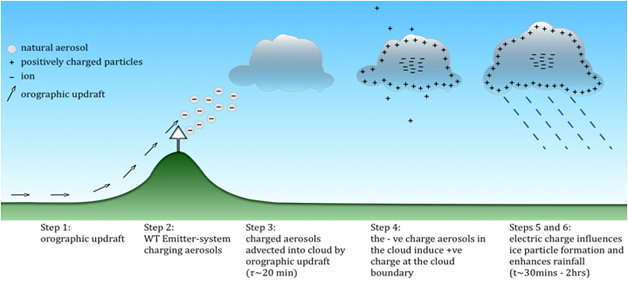
| © Copyright 2008 METEO SYSTEMS. All rights reserved. |
As most readers will recognize this illustration above, it's one of my all time favourites. It comes to us from the Swiss Company who claimed to have made 52 Synthetic Thunderstorm rains during the monsoonal season by tapping into the humid flow coming up from Somalia in the country and region of Dubai on the Arabian Peninsula in 2010. For me it is also a representation of the geologic feature of Cahuilla Mountain and the cloud manufacturing natural phenomena with it's conveyor belt assembly line system. The exciting thing for me was when I checked the Patents which are required to explain in some detail what they do to accomplish this task with this rain technology. The hill in the animation represents selected high elevation points where the towers were located. At these points, a process called orographic updraft can influence flow. From there a large amount of energy was used to transmit into the humid positively charged atmosphere those negatively charge ions [normally done by trees & shrubs] which would create interactions. But aerosols were also released into this environment to facilitate particle nuclei positioning for water droplet formation (clouds) to properly develop. What you all should understand here is that this proves they know precisely what is important for climate and what moderates, maintains and drives weather systems. It's more than just mere physics. Biological components are a must.
 |
Hydraulic Lift from deeply rooted chaparral
is an important component to redistribution
of moisture from deeper layers of Soil to
other plants on the surface. This connection
to deep ground conductivity and release of
their aromatic aerosols also add to our
climate maintenance. |
As previously referenced, Leonel Sternberg of the University of Miami pioneered important research on the Amazon Rainforests which provide a sustainable mechanism for maintaining these forests in the dry seasons by means of a ground water influenced weather mechanism which has no connection to storms off oceans. The forests incorporates hydraulic lift and redistribution and evapo-transpiration which helps create a ground to atmosphere recycling system of rainfall from tropical thunderstorms. Each day the process repeats itself. It's this same type of system I believe maintained forests in the southwestern North America with a very similar recycling to maintain the biological system even during summer periods or even drought periods, for which extremely deep rooted Chaparral mechanisms would tap into the seasonal monsoonal flows to create cloud formations. Of course most of the deep ground Aquifers would have been untapped, closer to the surface and available as a source of healthy moisture acquisition by deeper rooted plants to be evenly distributed among the entire plant network above. Conductivity, aerosols and evapo-transpiration would have been healthy enough which would have accounted for the greater bio-diverse life which once existed on Earth.
I'm making this post as a source of reference for my posts on what Juan Baustista de Anza wrote in his diary with the description of the richer plant and animal landscape he saw first hand and documented in text. At one time I had thought his work was an exaggeration, but clearly it was not. I also want to counter some of the myths of larger and greater forests of the region being in existence 1000s of years ago, when it is clear that the existence was even around in many areas just a few hundred years back. It may take thousands of years to create and build, but it takes a mere 150 years to wrecking ball it.
I also appreciate that much of this may be boring to most people, but knowing the natural mechanisms can actually help in rebuilding the Earth. Of course that's assuming that every individual on Earth actually cares and get's the implications of not caring. The one thing Science is incapable of doing is changing people hearts which motivates behavior. Scientists haven't exactly been the best of communicators historically, but that will have to change. Expecting such a thing to happen of course is like saying the world's leadership from Politicians to Religious Clergy will change for the better. Hmmm, "When the Sahara Freezes Over" - even still, practical application of things observed out in nature can still benefit people on an individual level.
~~~~~~~~~~~~~~~~~~~~~~~~~~~~~~~~~~~~
Some references:
(Note: Don't kid yourself that all this understanding is new and fresh. The Scientific authorities have known about these natural mechanisms for years and have done nothing to make practical application in replication of the observation. There are of course some exceptions, but the deliberate ignorance as with so many otherr beneficial subjects with regard to our natural world seems to be the rule. Otherwise our planet would look much morre different.)
An in Depth View of Earth's Climate Creation & Maintenance Mechanisms and the Synthetic Biology Science is Pushing as a Replacement Solution
Rainfall exclusion in an eastern Amazonian forest alters soil water movement and depth of water uptake
http://www.fs.fed.us/research/people/profile.php?alias=fmeinzer
Other related Research of Interest:
TreeHugger: "Pollution Prevents Thunderstorms but it also Makes Them Worse"
Update: March 2nd, 2015
Deforestation could shift monsoons, leaving India high and dry
Update: April 7, 2025
Soil conditions significantly increase rainfall in megastorm hotspots