When I moved to Idyllwild in 1981, a year later there was a horrific fire which took place down near the Hwy 243 & 74 Junction. Many in the town of Idyllwild went up to the Refuse Dump and watched the fire making it's progress on both sides of Hwy 74 and moving eastwards through the "Living Free Animal Sanctuary" and beyond into the grassy meadow Valley to the east along Keen Camp Road where it was put out at the end of this valley. The interesting thing for me was that most of this area burned was private land on either side of the Highway and no tree planting reforestation program was ever attempted, I know because I asked. What happened next was that the landscape was simply left to it's own restoration component mechanisms and unlike a disastrous Control Burn up Hwy 74 at Keen Summit where the California Division of Forestry allowed to get out of control, they actually did attempt a tree replant for what they had destroyed. Interestingly, the Mountain Center Fire did regenerate much better through the chaparral growth that had taken over. The other funny or should I say odd thing about that Cal-Fire Burn at Keen Summit is that they were attempting to burn off chaparral in order to save the forest, but instead actually destroyed numerous Coulter Pine and Black Oak trees that were in actuality encroaching into the predominantly Chamise and Redshank plant community which themselves were actually yielding to this tree encroachment. But this is something you never hear about. Residents and even the U.S. Forest Service were extremely irritated at Cal-Fire's blunder. But just take a look at the area in Mountain Center itself which was never touched by human hands in any reforestation effort. I recently visited this site a couple weeks back and photographed what is clearly seen as the surviving parent trees and their offspring.
 |
| Photo Mine |
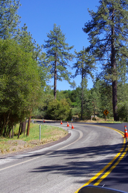
Just past the Y-Junction of Hwys 243 & 74 there was a road maintenance of Hwy 74 repavement project I had to stop at and wait for the Pilot Truck to escort us past the road work ahead. However, in this view here, these tall trees were never touched. The fire I believe started just behind the Post Office if I remember correctly. But the fire did cross this road and burn underneath many of these trees. While the trees here didn't die, they did loose lower branches to intense heat and smoke.
 |
| Photo Mine |
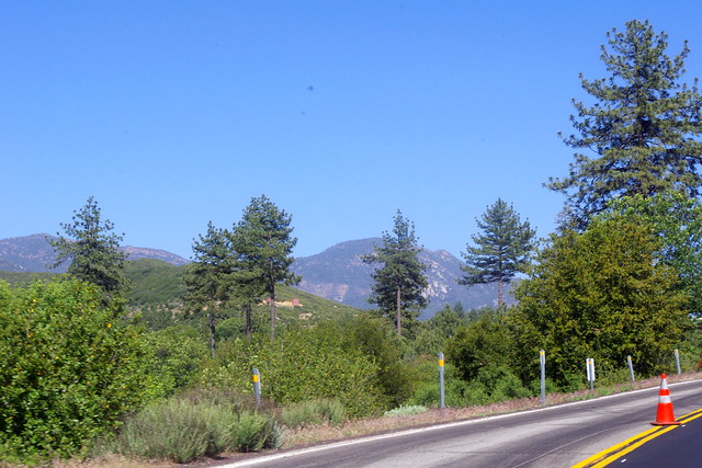
It was crazy trying to take these shots as the little 1969 VW Bug I was driving was the only way I could take the photos. I was not allowed to stop like I wanted to for specific close ups. But both sides here were clearly burned off and in the background you can see both Jeffrey/Coulter Pines and Interior Live/Black Oaks did make a beautiful come back through the vigorous regrowth of the Chaparral Plant Community.
 |
| Photo Mine |
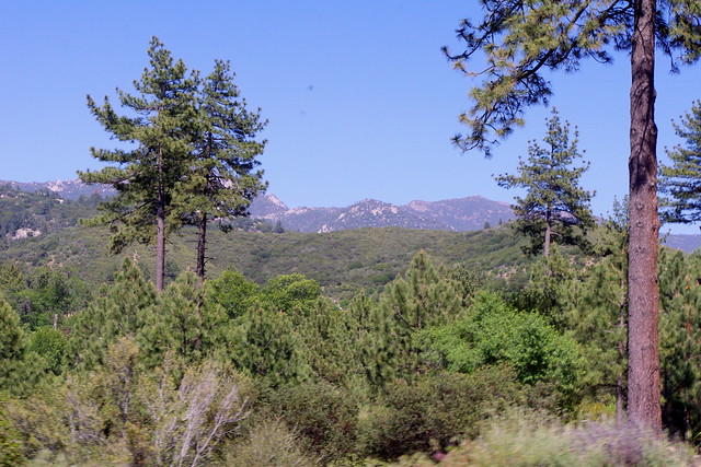
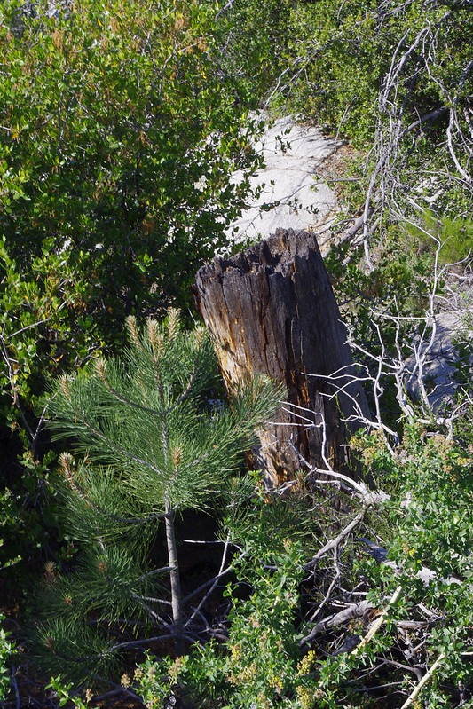
This is actually a very beautiful shot illustrating the parent trees that survived and the regeneration of trees which are actually triple what they were before. As you can see here, these taller trees lost their lower branches. The following week after this fire, I drove down there from Idyllwild on my way to the Desert and stopped to survey everything. The burnt lower branches at that time still hung onto the trees, but over time they have fallen off through the natural forces of self-pruning. It should also be revealed that not all tall trees made it completely. Many died and provided some important wildlife snags. I only wished I had taken photos back then, but never considered I'd be discussing these things at some future point of time.
 |
| Photo Mine |
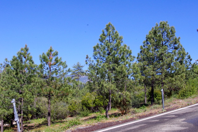
This is a closer view of the parent trees with the younger far more numerous trees below them which regenerated without the usual Forest Service land clearance which supposes that Chaparral is the ever evil competition and will hinder young sapling growth. The truth of the matter is that the Chaparral is the deep rooted infrastructure by which these newer generation of trees succeed.
 |
| Photo Mine |
Now moving up the Hwy 74 closer to the Jct of Keen Camp Road where you can get a clearer picture of just how many these younger trees are and how big they've grown. They are more than triple the size of the Tree Planting Project up the road further south which were planted on cleared and plowed land nearer the Hwy 74 Keen Summit closer to Baldy Mountain. It was sad really, because I don't want any project up there to fail, but why Government Scientists and Experts refuse to replicate Nature and continue to employ conventional farming method thinking is beyond me. It seems nothing has changed in years. But things are going to have to change as seed banks are destroyed and harder to come by.
 |
| Photo Mine |
This group of trees is just beyond the Keen Camp Road Jct. Almost immediately after the fire that following Spring, 100s and 100s of these trees sprouted up everywhere and of course so did the chaparral. I remember seeing what appeared to be the Chaparral plants overwhelming the area back then, but then only a few years later seeing the conical shaped tips of all those pines pushing their way through the Chaparral canopy. Now the trees here are dominant and it is the Chaparral that is yielding. Again, this is something the experts who demonize these plants never reveal as a fact of these mountain ecosystems. The fact is many of them never actually spend many amounts of time in the field themselves to test out their biased hypothesis. The so-called Scientific Method has taken on new meaning. You simply read it all in a book about what others did or accomplished years ago and then you fake the rest as you go along.
 |
| Photo Mine |
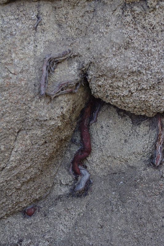
I'm showing this photo once again from the old Baldy Creek Hwy 74 construction diversion post I wrote a couple of weeks back for illustrative purposes. This is a prime example of what the Mountain Center trees regenerated through. The Chaparral is an important infrastructure which supports and props up the young pines by means of an extensive deep root infrastructure which hydrates the young trees and forcing their growth upwards towards the sky as opposed to open scenarios in which the trees put out more of a rounded branching structure.
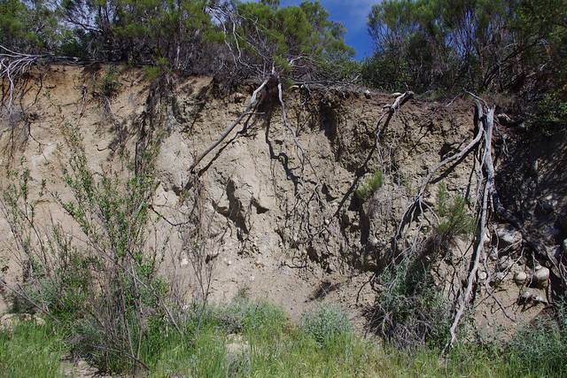
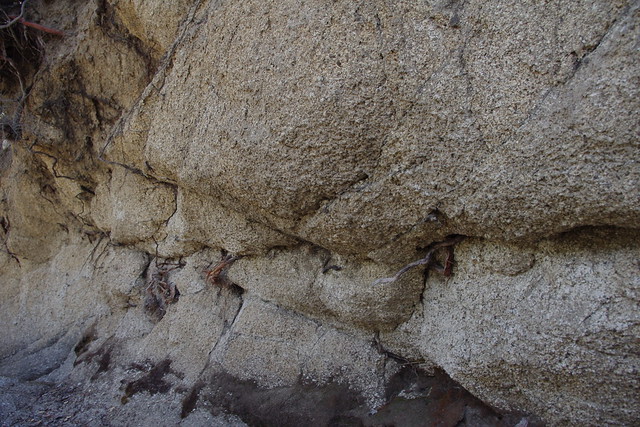
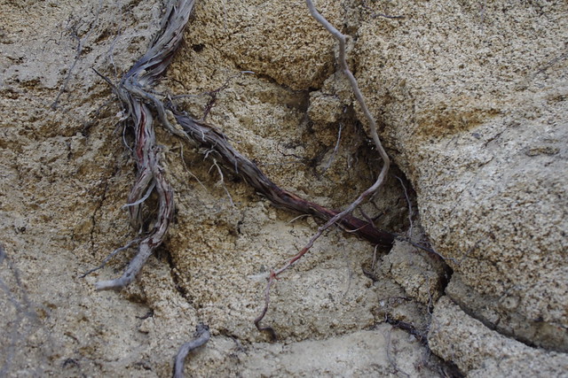
Also, by way of going back and reminding you of the underground rooting structure of Chaparral plants which is incredibly extensive, this was well illustrated in the photos I took of the unnatural stream channel cut through the hill forcing the stream to move westward instead of it's natural course due North towards Hwy 74. These 10 to 15 foot deep cuts are still sheer walls of exposed soil and fractured rock layers, but they also revealed how deeply penetrating and tough the chaparral plant community rooting infrastructure truly is. Take another repeat look at the potential for support of most future forested woodlands which many of the text books will not or refuse to cover. These simple fundamental basics should be taught at early levels such as Vocational Agriculture in High School, let alone College and other Universities, but they are not. The big important question now is - Why Not ?
 |
| Photos Mine |
Again, look at the unnatural cut into the hillside in the top photo and the lack of any riparian woodland along these banks. If this were a true stream bed, these natural components would be present and long well established. But also notice the beautifully exposed very deep root systems of the surrounding Chaparral plants like Manzanita, Chamise and Redshanks. If there is anything good that can come out of this, then these revelations of root infrastructure are it. All of these structures, coupled with mycorrhizal interconnections, are prime mechanisms for hydraulic lift and redistribution of water during the drier summer months and no doubt perform the other fascinating phenomena of hydraulic descent, That is, the transporting winter rain surface water deep underground during winter months. When these major natural mechanisms are removed in conventional Forestry for bare root tree transplanting projects, you can understand why such projects down in Garner Valley often required regular summer watering with a Tractor pulling a Water Tank Wagon by the U.S. Forest Service. I know because I often saw them watering while commuting to work. Even then many of those trees still died.
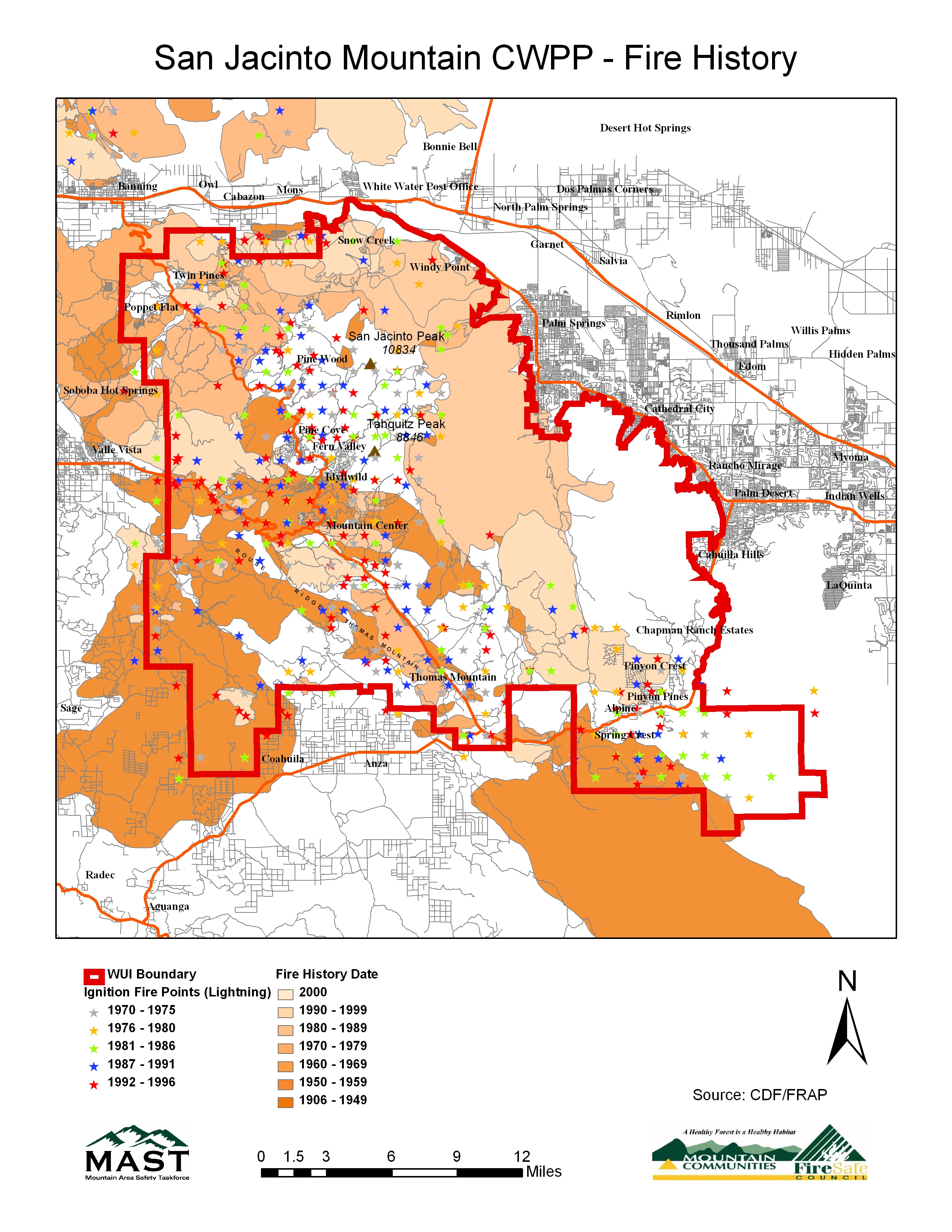
Here is an interesting link to a historical Fire map of the San Jacinto Mountains. Click on the link and magnify it. It will show the Mountain Center Fire boundary very clearly in the 1980s shaded colour and also both the Baldy Mountain and Cahuilla Mountain fires which took place in the 1990s in it's own colour shade.
San Jacinto Mountain CWPP - Fire History
For Further Reading of Forest Establishment by Natural Mechanisms in Replication of Nature, see the posted article a couple weeks back:
Establishing a Forested Ecosystem Where This World's Intellectuals Tell You it Can't Be Done


Very interesting, Thank you so much for the time and information. Drank it up.
ReplyDelete