"Earth's Internet" attempts to document, reference as much of the natural world networking abilities and strategies as possible. Such Scientific findings are at odds with industrial scientific approaches maintaining our planet. Be warned. If your learning approach it based on Memes with short clever quips, you may be disappointed here.
Showing posts with label Mycorrhizal inoculants. Show all posts
This photo was taken by GeologistWayne Ranney of Flagstaff Arizona driving through the Rajasthani Desert on his way back from Jodhpur. He has a blog mostly dealing with Geology, though I'm ever so glad he took this shot as it has a number of important illustration and teaching feature visuals. By all means visit his incredible blog and that of another incredible Geologist who has a great ability to teach layman the complicated facts in easy to understand terminology. - Dr Jack Share.
So now back to reversing barren wastelands into productive wonderlands. My previous post (Part I)
I addressed a few examples of barren wasteland situations around the Earth, many of which have had a human cause that desperately need turning around. Our planet's rainfall and climate mechanisms are dependent on our reversing the damage caused. This intro is found here:
One of the foundations of any ecosystem is the hidden invisible universe so to speak that operates under the ground and I've already written about this in a piece about the Earth's Biological Soil Crusts. - see Footnote - To term these soil components as nothing more than primitive organisms is an insult to the biological mechanically running world. That would be like comparing a powerful brilliantly engineered expensive Rolls Royce engine to it's Cooling System Hose and insisting the Engine is far more important than the lowly hose. Yet that Rolls Royce engine would be nothing without the Cooling System Hose. Take a quick view of this short Video which was recently recorded on the Bio-Crust Site called:
It gives a great illustration of how and why such microbiological organisms would be to a restoration site. This is clearly a new field to most folks, especially in the area of practical applications. But if you paid attention to that video, then you understood the importance of these bio-crusts to bind desert soils together which would be ideal between your tree plantings as in a Dune Project. Take a good healthy look at the Acacia Tree covered sand dune above. The only thing you truly see and observe is the picturesque treescape itself, yet no consideration to the biological networking activity going on underneath the ground. Even the SDSUMesquiteDune Project had problems with the Dunes they created blowing away. Anyone who has ever been there at that wintery/spring time of year knows how fierce those western winds out of the mountains from the Pacific Ocean can be.
Jim Sears of Terraderm
There may be a problem solver in the way of commercially developed Soil Biological Crust spray applications from that company in Texas called TerraDerm. Sadly the company is now gone. The overall idea is to spread as many of the Bio-Crustal Spores over a wide area as possible to allow germination of the cyanobacteria to pioneer the way for algae, fungus, lichens to germinate creating a crustal surface which will hold the soil in place allow much larger succession of plants can get a foothold to take over the ecosystem creating a new forest. Well, here's a bit of an update. Terraderm is no longer in existence since 2012, but here is a Vimeo intro that still plays.
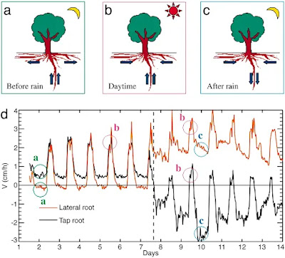
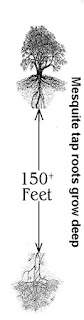
Imagine the tree on the animation is a Mesquite Tree in the Sonoran Desert or Acacia Tree on the African Savanna. These are foundational trees which will drive and maintain an ecosystem to life. Remember also these mechanisms by which recent research has proven that such DEEP ROOTED trees have a higher ability to discharge electrical current and aerosols into the air aiding in cloud formation and eventual rainfall, but ONLY if they can connect to healthy subterranean aquifers and the electrical conductivity of Earth's deeper underground. As the Acacias, Mesquite, Paloverde, Ironwood trees, etc reach maturity, then the mechanisms of Hydraulic descent can ALSO kick in and take over sucking as much surface soil water as possible after rainfall and pumping it deep into the earth to later be utilized through Hydraulic lift and redistribution as needed. If there are times of heavy seasonal rainfalls, then such mechanisms may even restore a measure of Aquifir water table levels previously lost (Human Agricultural Activities), raising those levels to better serve the environment and even humankind if they are able to utilize such resources responsibly. This is the healthy process that should be your goal in any productive restoration project.
This is the goal, to create a rugged tough surface from sand or other soft desert soils into a rugged pattern to slow down any rainfall event which comes along to better percolate water into deeper layers of the soil. Yes desert storms can be tough & intense, but this now present biocrustal soil ecosystem is a far better improvement over the previous barren destructive surface you are attempting to reverse.
Think in terms of a deep Engineering Project as opposed to a mere surface terrestrial Gardening idea. In other words think long term future!Much of the desert plants around the world themselves are actually having a tough time with the climate change as well. Much of this of course is caused by various forms of deforestation being promoted throughout the Earth plus the rapid depletion of water in deep Aquifirs where what is called Fossil Water is being drain for irresponsible Agricultural irrigation practices and use for major world cities municipal needs. As these levels lower, even many of the deep rooted foundation trees will suffer, preventing the mechanisms of Hydraulics (lift - redistribution - descent) to fail completely hurting other plant life in their respective community. This also stops the cloud formation mechanisms (already referenced here) and more importantly normal rainfall patterns. Rebuilding this system again and restoring these networks and learning how to use these plant instincts for you instead of using them against themselves takes a total 360 turn around in the thinking on the part of this world's leadership (Politicians, Big-Biz, Scientists, Average Joe/Jane etc). Given the past historical patterns of failed leadership of this world (and I could care less whose ideologically flavoured Political Party) , most likely this won't happen unless forced to as always. Sadly more often than not, it's usually to late. So this info is mostly for those who actually give arat's backside and want to benefit from practical application through their own landscape, garden, farm, Guerrilla Habitat Restoration or conventional restoration, whatever!!!
Most of my focus has been on Mesquite Dune projects and specific desert environs where soils don't necessarily have a lot of obstacles such as bedrock or hard pan barriers. So most illustrations I've given are perfect in their ideal appeal to taproot development, but not all geology is the same. For example my mum's property has very deep sandy loam soil whose origins come off a rather large mountain over a period of 1000s of years into an alluvial fan. That's why her California Sycamores have done so well. I knew this ahead of time and trained these 1 gallon trees into the deeply rooted 30+ foot high 6 year old trees they are today. Knowing soil dynamics and structural makeup truly helps. Not everything considered to be deeply taprooting trees or shrubs will respond favourably the same way. But there are possibilities and other viable options. Recently info has come out though that illustrates that even in tough soils with taproot engineering goals, such obstacles as clay and bedrock can be over come by the plant. See:
Source: Soil Types and Structures Module DEPI, Victoria
Sometimes depending on soil geology they may fail or simply take longer finding those open soil fractures to drive deeper.Take this illustration here to the left. It animates what is called Hard Pan which is a dense compact layer of soil which is almost like condense compacted concrete or rammed Earth for which water movement and even root penetration is almost ZERO. Water drainage is a big problem. The illustration shows where drilling or some other break through may be necessary to create a favourable change to this type of soil dynamics. This is exactly the kind of soil problems found around San Diego areas on the Mesas like Kearny Mesa, Miramar and Sierra Mesa where hard pan is common. These communities are basically all on the same table lands and have almost identical sub-soil issues. It is some of these features which allow for Vernal Pool development in nature to work. We (the Property Management Co I worked for) had an apartment complex where we needed to make some underground plumbing system changes. The hard pan was just below the surface at about 5 foot deep with the hard pan itself being a foot to foot and a half thick. It literally is as tough as concrete and the porosity just as bad. We had to use Jack Hammer and to punch holes through and once opened up a backhoe took care of the rest. Soil below that is well draining. Prior to Human building of the area, native vegetation for the most part was never trees, just low Coastal Chaparral scrub.
Many deserts have this feature of an Alkali Hard Pan a meter or more under the soil, Texas has areas such as this. Australia and Africa are others. Good indications can often be seen by what plants naturally occur there. Don't look at it as a negative. Change your viewpoint and consider it an incredible challenge to make a difference. While there may be an element of mechanical fracturing and added expense, biological components for the most part will do the rest. When I lived up in the San Jacinto Mountains, many folks never considered their geology when purchasing their prized 180 degree view property. They often were given the sad news when applying for Septic Tank permits from Riverside County which demanded what is called a Perc-Test (rate at which water percolates into the soil). Several areas will be backhoed with trenching in the area you want your leach field. Water is then filled into the trenches and it's a waiting game to see how long it takes to saturate into the soil. Sometimes it never will, which indicates a problem for any future leach field. So if you have a nice permanent pond, you're in trouble.
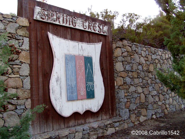
I know of one such property in the Spring Crest area of SantaRosa Mountains above Palm Springs CA. The underlying ground material was hard granite bedrock. It didn't perc well. Negative Perc-Test, no House Building Permits. Solution often used there were to drill numerous deep narrow holes over a given area and load these holes with just explosive charge enough to fracture the granite bedrock underneath to allow water percolation. But hey, that may be an option for some Habitat improvement. Thereafter trees roots and proper microbiological material properly injected into the earth should take over from there.
The above link has a great article on root structure couple with microbial interactions and climate change.
photo Pinal County Arizona
To restate, it was once believed that only those perfect sandy loam soils could facilitate rapid successful movement of deep taproots into deeper layers of soils. Of course this thinking could never explain why giant old growth forest trees are capable of existing without such a formidable anchor. Botanists simply did not believe the roots could drill their way through compacted clay hard pans, terrible rocky mineral soils devoid of much organic matter or even extremely hard granite or other bedrock material. But later research proves that plant roots can penetrate these types of soil structures. We even have some examples of Foothill Paloverde in Arizona which colonize tough rocky layers of Earth with little soil to speak of. Clearly further research and study of such amazing drilling mechanisms and specialized abilities of such plants will be of benefit
Colorado Guy
How does Foothill Palo Verde or even Catclaw Acacia which are trees known for drilling deep taproots, actually bore holes through solid rock as in this picture to the right here of Picacho Peak which is a famous often seen Arizona landmark along side Interstate 10 ? This is generally the halfway point between Tucson and Casa Grande. The are other examples everywhere in the park of Arizona, but this is the easiest to point out. Clearly anything is possible!
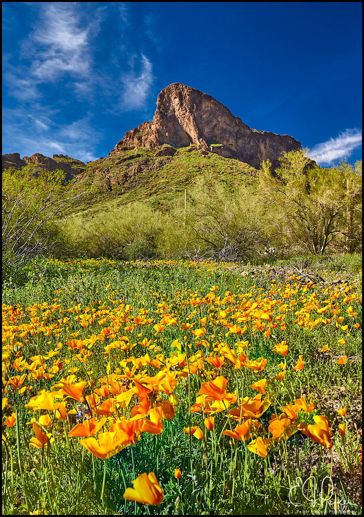
Seriously, even here on the top of the Peak with less than ideal soil. No Sandy alluvial flood plains here. What some plants are able to accomplish is amazing.
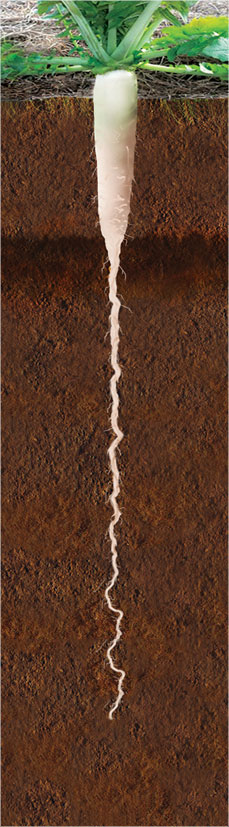
The roots of the Tillage Radish are able to bore through this hardpan layer and reach depths of 1.2 meters. This soil profile photo was taken exactly one year after the crop was planted, yet the roots are still serving as a conduit for water penetration as shown in the area outlined in white in the photo. If a lowly radish can accomplish this, would would a hardy tough rugged desert tree like Mesquite, Ironwood, Palo Verde or Acacia to accomplish ?
Another beautiful illustration of the spiraling drilling mechanism of a taproot comes from a company which sells Tillage Radish seed to farmers as a cover crop which not only opens up deep layers of subsoils, but also acts as a cover crop to prevent weeds before planting corn next season. But lets focus on the spiraled twisting nature which is also found in the top growth of any plants. One has to wonder if a measure of water is injected into the ground by the Mesquite or Acacia tree taproots ahead of the root cap to facilitate opening of tight soil particles. So Hydraulic descent may even start very early in the plants life rather than later. One can only imagine and speculate since in most desert ecosystems, rainfall is often less than 3 inches. Germination takes place, seed drives spiraling root shaft quickly into a foot or so of moist soil layers from present rainy season at best, then power drills through nothing but dry layers of Earth's subsoils thereafter before hitting the actual water table below. Once again science has discovered and illustrated the mechanism by which such amazing engineering feats in nature are possible. But do you have the insight to replicate such engineering into your landscape or Habitat Restoration blueprint ?
This study involving research on the water hydraulic lifting , redistribution and descent abilities of the lowly High Desert Silver Sagebrush found in the state of Utah or Nevada. And never discount the ability of what looks to be nothing more than a dull mundane low growing shrub like the Silver Sagebrush above which has amazing Hydraulic Lift and redistribution abilities which actually support a healthy plant community, though you may not wish to view it that way. Okay let's shift some gears here- Tamarisks, I don't want to spend much time on this one as I have a post dealing with Tamarisk Trees. There are good and bad points on many living things, in this case not the plant, but the Human Idiocy Factor. There are incredible opportunities for more responsible construction of desert windbreaks utilizing local resources at very little cost. Here is the link:
Trees, and even more specifically forests, have been shown to be critical for regulating climate and creating cooler microclimates, for building soils and therefore the water retentive capacity of the land (acting like a giant sponge that releases water slowly), for reducing erosion and its resultant siltation of waterways, for reducing salination, for creating wildlife corridors, for acting as windbreaks, for supplying humanity with both timber and non-timber products, for cleansing water and for creating the air that we breathe.
Start Getting A Clue. The Earth has very little time left !!!
These say pictures can convey volumes of information that a multitude of words could never accomplish. I'll start off here with some pictures that really could illustrate land maintenance practices that are found on any location on Earth in any country. The two pictures below are only illustrative of what the subject of this post is all about and the company from where the photos were taken no doubt does a professional job of manicuring the land for which they are hired. It is hoped however that people will gain a better understanding of what goes on under the ground before they hire such a company or take upon themselves any personal land clearing project. The photos below are merely typical of what is experienced in the clearing of land.
Now the company that cleared this land is out of Texas and no doubt obtains many such work contracts. In fact on their website they show a number of pictures of the bulldozer clearing the land by scraping with a blade and pilling up a combination of mangled brush and soil in piles or a long rows of debris pushed up against the property line. This is often typical and I saw this numerous times when I lived up in Anza California. On that website, the bottom photo proudly displays the text: "Cleared Field After 20 Years". Yep, I believe it and have no reason to doubt those words. They did an effective job so that the land would never see a great amount of vegetation ever again.
The land prior to the clearing project most likely had a healthy'Mycorrhizal Internet Grid'. Yet now it most likely has more of a bacterial system to replace it. A bacterial system, as Bert Wilson of Las Pilitas California Native Plant Nursery says, favours what are called plants that are known as'ruderals' (we know them as seasonal or annual plants, like weeds for instance) and usually a healthy ecosystem with a 'Mycorrhizal Internet Grid' under the ground tends to keep those weeds in check or at least balanced out. Take a walk or hike anywhere there is pristine chaparral plant community conditions and you will not find weeds as the over powering dominant force you find in open ranges created by humans for livestock raising. Though you will find such annuals here and there, the mycorrhizal grid is a protection and a sort of natural antibiotics for the health of any forest or chaparral community's soil.
Looking at the bottom picture above, you'll notice that though it still looks like grassland after 20 years, the question comes up, 'Is it really the right type of grassland ?' What I see in that photo is mostly annual plants like wild mustard, maybe even some various types of foxtail grasses. Nothing wrong with annuals (or believe it or not weeds), they do what they do best and that is cover the land quickly. That's important because when rains come, they're function or purpose really is to slow water down as opposed to letting it run off and erode the soil. If a bad brush clearing job has been done and the top layer of biologically rich soils have been remove, then it may take years for vegetation of any kind to come back and in the mean time valuable top soil has been washed down stream. Again, anybody in any back country situation has seen what I'm talking about, though you thought nothing of it at the time.
The real objective goal in any land management project should be to eventually replace the annuals with perennial system. That would be plants that live for a season being replaced by plants that may live a decade or more. For example, thatPastureland Project (if that was the intended goal of clearing the brush in the first place)above should be mostly perennial bunch grasses and other beneficial plants that one would find on a pristine prairie setting. Something like the picture below where deeper rooted bunch grasses and other plants will allow a greener ecosystem to last longer or in some cases till a summer monsoonal system kicks in.
These are individual grasses that under the right conditions send their roots down several feet into the earth (in the correct soil setting) which allows them to tap into sub-soil moisture which means they stay greener longer than those annuals that rapidly produce more seed, quickly dry out and then die only to be repeated year after year. A perennial grassland system is more desirable and is going to be more productive if you've got a livestock ranching program. The system will be more nutritious and better at self repairing after the animals pass through, that is if the rancher manages things properly. Many residents up in the Anza area when I lived there were even clever enough to transplant many of the native bunch grasses on their land into small areas of a lawn. Very clever considering Anza is a very dry air region whether it's hot or bitter cold. Those bunchgrass lawns can stay green with very little watering once established and will eventually come together and fill in the bare spaces in between them.
Sometimes the goal of the weekend ranchette landowner is to remove what is considered the undesirable plants with what they view aesthetically valueless. In Anza that most often is a tough little shrub or brush that will grow where nothing else will and it's calledChamise or Greasewood (Adenostoma fasciculatum)
Image - Neahga Leonard
Seriously, who wants such a jagged stickery looking nasty bush like that in their landscape ? You should. As mentioned, they often grow where nothing else will. Much of the soils they grow on is very shallow and rocky and not very deep. Remove them and try planting something you thought was cute choice or pick from the local nursery and would be a better fit in your game plan scheme of things you envisioned than that ugly old Greasewood and then watch it fail. One thing that most people who come up from the city and who buy that dream home piece of land never do is take their time that first year and get to know their wild landscapes and the ecology and geology makeup of their own property. Know something about the wild plants on that property and what they find as optimal growing conditions. Let's go back to the Greasewood as an example. Under perfect growing conditions, even a Greasewood Shrub can be found growing as a small tree, though it has to compete for this with other plants that like the perfect growing conditions.
But when you see Greasewood grow in large masses or groupings on a rise or hill knoll with no other plants around and only about a couple of feet in height, then that can often tell you that below the surface there is a nasty rocky, probably bedrock situation close to the surface type of geological soil condition. Nothing else will grow there. You can check by trying to force a shovel or even a pry bar to see what's down there. Not only will your much desired plant from the nursery fail under such soil profile, but you will even rarely find the usual nasty weeds growing there. So leave the Greasewoodalone. It's performing a couple of important functions for your property.First, when rains come, it slows the water down from completely running off, which is what you want it to do.Second, under that nasty ground there is still a'Mycorrhizal Internet Grid'which I guarantee you is intact underneath those plants otherwise the Greasewood itself wouldn't be able to survive. And that grid is also connected to another grid that is networked further away in more desirable locations connecting all plant communities in the Network of cooperation for survival. And Third and possibly the most important factor is it's ability to sprout back after a fire and continue to hold the bare ground somewhat intact when the next seasons rains finally come.
Yes, google images of the plant called Greasewood or Chamise and you will find a third of the images appear like the above. It's called Greasewood for a reason. It has a lot of volatile oils within it's wood and it is prone to wildfire situations. Anybody who moves to Chaparral country ecology situation should expect and prepare for wildfires. It's true that it's a natural part of the environment, but what is unnatural is the ever present growing frequency for which fires today come and go. The more people the greater the chances. No matter what you plant, even if you think removing the brush and replacing it with what you think is less fireprone or resistant, the reality is nothing is resistant to these later day firestorms which are more intense now than in times past. Everything will burn, but the natives will sprout back and hold your land intact better than the transplanted urban landscape reconstruction you assumed was a better idea.
Now let me change channels here and show you some example photos of what some folks with good intentions and motivations for clearing land of the jagged stuff to make it more aesthetically appealing to the human eye. First off up in Anza where I lived, people often removed what they considered that nasty looking Greasewood to reveal more the more 'Eye Candy' pleasing shrubs like Manzanita. I love Manzanitas too, but they also need the other surrounding vegetation ecosystem infrastructure to fully benefit. Many times they will die sudden death after land clearing for no visible apparent reasons. But clearly the disruption also took place under the ground.
Image - Bert Wilson - Las Pilitas
See this beautiful Manzanita up above ??? Yup, no doubt about it. That's one of the best looking natural wild shrubs to be found anywhere, and who wouldn't in their right mind choose that over less desirable brush like Greasewood ? So here's what their land may often look like after the land clearer has followed their strict instructions of what the want and expect from him. Of course the ultimate goal was to remove just the ugly and while keep the kool stuff.
Okay, we all get the idea about clearing (cleaning) the land up and leaving the desirable things. I get that and actually agree with it, but there are things to consider. Yes, of course the Fire Marshals ordered you to clean the land up, but then you cared about your land enough already and were going to do that anyway without them making you do it. But now consider the methods you use. The 24 years I spent up in Anza, California, I saw folks hire someone who was in the business of brush clearing or they themselves with their own little Adult toy Kubota Weekend Farmer Tractor and using that blade to literally scrape off several valuable inches of that biologically rich topsoil down to a clean sterile looking decomposed granite type of soil so that they could plant a yard that looks like this example below. Here's some more examples of land clearing in which selected desirable trees or shrubs are left. But often later some of those saved plants may die.
The photograph below this paragraph is take from the website of "The Chaparral Institute"which was taken I believe in northern San Diego County. It illustrates panic over fire danger and the mastication method of chewing up and actually stripping the landscape to reveal nothing but raw bare sterile soil which may no longer contain the natural grid which was installed and regularly maintained by nature for thousands of years. Even if the saved single or grouped specimens of Manzanitas, Oaks or Pines make it for a time, they may eventually die as a result of being disconnected from the "Earth's Internet". Such geographic landscape profiles don't necessarily have sub-soil water stores from which to draw from. Before the masticated land clearance, those plants were dependent on their being connected to the complete mycorrhizal and plant root grid that was networked completely around those slopes to facilitate water transportation from lower stores further down the slope during the dry season. Now they are up dry creek so to speak. This practice is parroted by many landowners who actually lose some of their prized shrubs when they believed they were doing a good thing in manicuring their property.
"California Native Plant Society"
Here is a quote from under the photo:
"The cost of viewing chaparral as fuel. This remarkable stand of
manzanita chaparral in the Cleveland National Forest that was featured
on the Fall 2007 cover of the California Native Plant Society’s
quarterly journal Fremontia was masticated by the USFS in 2008. The
mastication shown above continues around a Coulter pine tree
plantation. The area is miles away from any community"
"Rather than dealing comprehensively with wildfire risk,
many local governments are promoting vegetation “clearance” strategies
that seriously compromise protected wildlands, challenge the integrity
of habitat conservation plans, and increase the spread of invasive
species. Some San Diego County officials have expressed the desire to
exempt such vegetation “treatments” from the California Environmental
Quality Act. Under the federal Healthy Forests Restoration Act, millions
of dollars are spent to “treat acres” rather than dealing with fire
risk where it would be most effective, immediately around and within
human communities. Please join us as we discuss threats posed to
California’s native plant communities by misguided fuel treatment
projects and what you can do to help protect San Diego County’s native
plants from unwise land use policies."
This next photo below is again taken from"The Chaparral Institute"website which clearly shows what grows back after stripping the land of it's natural mycorrhizal grid into a bacterial system which as Bert Wilson points out favours plants that are 'ruderals' as in this case foxtails & non-native oats which in fact burn like gasoline. At least brush could have slowed a fire down somewhat, but now is facilitated by a more combustible fuel which when high wind fed on a ridge will allow fires quicker access to the other side of the ridge. At least with fires slowed down with brush, fire retardant dropping planes could make a ridgeline strip ahead of a slower moving fire than one blowing full steam ahead in a grassland setting. However, it should now be noted that with climate and weather pattern change, these higher winds are more common than any time in the past and nothing really will stop them. This can be seen from the last several years of firestorms which have devastated many communities prone to such problems.
Chaparral Institute: Ridgeline Fuel Breaks are worthless
This next picture below I've taken off another blog by a gal who lives in Murrieta CA. She's into native plants and this picture is not a bad example of land clearing but is rather an illustrative example of what some land clearing can look like when some plants are selected to be kept. In this case she has replanted with native plants to establish more desirable that she appreciates into here garden environment. But notice the irrigation drip system. This is what is keeping the plantscape live until a proper root system with mycorrhizal networks can take over. Now I like a clean looking property, but the
only thing really keeping these plants alive is the constant presence of
the drip irrigation system and that's if the critters don't chew it up.
One note of caution here though is that you should NOT allow your natives to become dependent on a drip system. The ideal thing is to gradually ween them off it once established. Believe it or not, at my mum's house, though I did install an elaborate irrigation system at her house in El Cajon CA, most all the plants have roots down deep enough to penetrate deeply to get to sub-soil moisture which is what they want anyway. So the system is not on any timer and is only needed occasionally because of a few water loving plants like 'California Spicebush' and some wild currents in the understory of the trees.
image: Arlene Webster
If the biological material (mycorrhizae, beneficial bacteria, etc) has been removed or scraped off and pushed to the property line and even if they inoculated the ground within each planting hole, it will take much longer time to recover. Those native plants BTW that people try and save will often succumbed to sudden dying with what appears to be no rhyme or reason to the landowner.
Now back to the prized Bushes that were saved, like those wonderful Manzanitas. How many times have you seen someone's property that was cleared to leave only the desirable Manzanita plants which may look like this example below in the picture on a manicured sterile kool looking landscape. I actually like a clean sterile sort of landscape in my immediate yard, but a little of the plant's own dander or mulch layer should be left. Again below here is another nice picture from Arleen Webster in Murietta CA landscape. http://camissonia.blogspot.se/2012/02/manzanita-bloomfest-continues-but-we.html
image: Arlene Webster
Only a year or two after a property owner's land clearing job was done, some of them died unexpectedly and look something like the photo below ? The shrub starts out slowly by allowing some side branches to die back as a strategy measure to save itself from lack of moisture which it may have had prior to brush and soil clearing which took away the grid network underground where other plants had water access and shared these with your prizedManzanita only to later eventually die as a result of an ignorance on your part for not being acquainted with the"Earth's Internet".
I know from first hand experience. I've done a lot of stupid stuff and
learned the hard way. Take a look below. This is what is left after I cleared all the other shrubs around aManzanitathat was originally 10 times the size of the skeleton you see in the photo taken last year what we visited my old property again. The small tree was almost 20 feet in diameter when I first bought the place in 1985. It wasn't so much the height of the tree that was impressive, but it had numerous large side branches that grew up and out finally to heavy to stay upwards and lowered to the ground only to re-root (often common in Manzanitas) then grow back up into the air to create another extension of the original tree. Never did a trunk ring core sample, but it had to have been a couple of hundred years old maybe ? Who knows, it's gone now.
image: Mine
It was after my own bad experiences that I realize
clearing slowly by hand and then replacing the cleared undesirables with
something more appealing, usually another native was the answer. Also I was never in a hurry after that. I got some other neighbours and friends in the area involved
in planting pine trees and incense cedar on their properties purchased from L.A. Moran Forest Nursery near
Davis California. They shipped bare root trees around March if I
remember correctly and you had to get them in the ground as quickly as
possible. The land cleared by hand was superiorto the mechanized cleared
land. Those trees planted in hand cleared ground grew faster than the land
where the grid was disrupted by machinery. This practice of the superiority of hand clearing is also born out in a report of
Tamarisk Removal down in the Coachella Valley at 1000 Palms. Plant
restoration was faster and more complete on one side where Tamarisk was
removed by hand, than land cleared of Tamarisk by machine. If you have
the time, take a read of the report here below.
Here are some important quotes from that report. Now pay attention.
"Most areas were cut by hand, thereby selectively cutting out the tamarisk while leaving the native shrubs unharmed. Only a7.5 acre (3 ha) section that was heavily infested (> 95%) was cleared using a bulldozer."
"In the 7.5 acres (3 ha) that wasbulldozed, natives established much more slowly than in the hand-cleared areas."
~~~~~~~~~~~~~~~~~~~~~~~~~~~~~~~~~~~~~~~~~~~~
Remember my post on how the grid works and my Coulter - Jeffrey Pine Tree experiments I mentioned on my Hydraulic Lift & Redistributionarticle here:
In that post I explained and illustrated how all plants can be connected to an undreground interconnected grid of 'Mycorrhizal Fungi' Same species of plants or different species of plants can all be connected to this grid. I showed that no matter where I placed the irrigation dripline, that eventually the entire 24 trees were hydrated from the original source of H2O but only because they were connected to the grid.
For a moment, let's illustrate things this way by considering all sorts of human infrastructure for which we all are dependent and easily recognize in the real world. Electrical Network grids, Gas Pipelines Systems, Plumbing Grids of water Companies, Internet Cable Networks, Telephone Network systems, etc. Now in order to receive the benefit of these services we understand that we don't need to have our home literally or physically connected to the source of that service provider by being right next to it. Let's take a look at an electrical grid network map example of the United States.
Image Source: FEMA
So we all understand that on that major network of the grid systems are the original sources of electricity by Hydroelectric Dams, Coal or Gas fire Electrical Plants, Solar Farms or even Nuclear Energy Plants. We also are aware that we don't have to have our home physically next to one of those Industrial Plants to be able to plug or tap into the system to receive benefits. In fact we understand that we only have to be connected to an infrastructural grid as installed by the electric company as pictured below.
For you folks in Anza, this is how your Anza Electric Copperative works. You don't need your home to physically be on Larry's Agri-Empire land next to the Coop's building to receive electricity. Just connect to the grid they've intelligently built and if it's not available and you've got the big bucks to shell out, they can string the grid to your own home out in Timbuktu (RimRock Rd). Okay kidding.
The same is true of all plants. Many plants will be located at the sources of water, be they streams, rivers or lakes, or even ecosystem foundational plants that are able to tap into several meters deep moisture caches or reservoirs, then lift & redistribute from their tap roots to their nieghbours thru the 'Mycorrhizal Network'. Most likely those sensitive Manzanitas may have had that grid system disrupted. They likewise can often be found on top of knolls where the soil is shallow and rocky and seemingly dry, yet they thrived because they were tapped into the system via some of those Mountain Mahoganies or Redshank you didn't think were good looking enough for your overall future plans. This is why it's important to examine your land for a year before you make major decisions you'll wind up regretting as I did.
A prime example for Anza of large trees connected to the grid when they look to be in a dry impossible location is when driving up the HWY 371 as it enters the Hamiton Creek Canyon. Look over on both sides of the canyon. Notice that this isn't exactly ideal garden soil, yet look at the many huge Jeffrey, Coulter Pine and Interior Live Oak trees on those dry rocky hillsides. There is not even hardly any natural mulch layer under those trees. The actual rich water source is way down at the bottom of that canyon in Hamilton Creek. Yet, there are plants there like the willows and maybe some cottonwood, which BTW are also host to the same Pisolithus tinctorius Mycorrhizae that colonizes those pines on the canyon hillsides. These trees may be the fascillitators for transporting through the grid sources of fresh water to other life around them. The ability of this fungus to transport water 200' up a mountain side can be seen in many examples where the grid is intact even on southern hot and dry exposures coming up from Hemet to Mountain Center on HWY 74.
For more info on what some call the Dog Turd fungus go over to Tom Volk's website and have a read. Hope this was informative to all. If you are aware of your natural surroundings when out hiking, you'll recognize this puffball or truffle around many of the scrub oaks or pines trees where you live. Especially not long after lightening storms which I'll talk about another time.
Image: University of Wisconsin
The above truffle which is nothing more than the actual fungi's fruit is also the same one creating this internet grid in this famous picture referenced around the Net. Aren't Illustrations Informative ? Think about the map of the electrical grid of the United states you just saw.
Image of Hong Kong - Kim McAdam
Just like a beautiful modern city like Hong Kong, the city needs all of it's hidden underground infrastructure to operate at optimal levels (sewer, water, electrical, internet, etc) in order to operate at all or it ceases to exist.
Image - Untility Safety & Ops Network
So watch the video below from the BBC. The same exact infrastructure networks and functions are also important for the aboveground forest or shrub life to equally function and thrive withy efficiency.
Next video is a further more complicated video explaining the complex underground infrastructure, but equally entertaining and education. Presented by Suzanne Simard
Try real hard an picture in your mind's eye what the underground looks like under your property the next time you want to plan something for the landscape. Kill it and your landscape will fail miserably. Enjoy!
When I think of Todd Dawson's work, I think of my own obsession of wondering what is going on under the ground as opposed to walking through the woods and looking at all the beautiful scenery. Yes of course the scenery is beautiful and exciting. However, my metamorphosis and obsession with underground biological life networking came about over a long period of time. While I always had interest in 'Botany'&'Plants', I gradually came to realize through my own study and research that a healthy above ground paradisaic scenario is made only possible and a success by a properly installed under ground networked system. Nature, when not interfered with, takes care of itself. However, human's on the other hand are wowed by the Ooooooo-facter of various Large Corporate Marketing Schemes when it comes gardening and landscaping. Billions of Dollars in advertising over almost a century has indoctrinated people on Earth that Chemicals are the answer for your every need in the garden and landscape and without them you are bound to fail. Careful consideration should always be given to just exactly how things work in nature and then simply replicate these processes by developing practical application concepts into your own project. The mistake comes when mankind believes they can out perform and improve upon nature. No need to list the failures of this thinking. Anyone can read and listen to the News today and see that human's are rapidly destroying our planet. That aside, let's get back to what work Todd Dawsonand his team have pioneered. There are terms and phrases they research called 'Hydraulic Lift' - 'Hydraulic Redistribution' - 'Hydraulic Descent'and all of this has to do with a root phenomena where by roots of key species of any type of ecosystem facilitate the redistribution of water and nutrients through yet another complex and sophisticated piece of "Earth Internet" hardware called a mycorrhizal network or grid. These mycorrhizal organisms are nothing more than beneficial fungus which uses mycelial network fibers to inter-connect with various species of plants in an underground mutualistic association. In a nut shell the fungi provide an increased rate of absorbtion by 200% of water and nutrients and gives these to the trees or shrubs and in turn, the fungi who can't manufacture their own food through photosynthesis are rewarded from the plant carbons and other sugars by which the fungi survives.
Below is an animated illustration off Todd Dawson's Lab sitewhich beautifully illustrates just what happens during daylight hours, nighttime and even during the rainy season when trees and shrubs are in dormancy state.
Animated imgage - Dawson's Lab
Sap velocity in the taproot and lateral root of P. robustum during the transition from the dry to wet season in the Floresta Nacional do Tapajós.(a–c) Schematics for water movement at nighttime before the rain (a), daytime before and after the rain (b), and nighttime after the rain (c). Arrows shown the dominant flow direction determined by sapflow. (d) Graph showing sap velocity. Positive values mean that water flows to the plant, and negative values means away from the plant into the surrounding soil. The dashed line represents a rain event (36 mm). See the text for a complete explanation.
One of the first articles I ever read was a piece done above Todd Dawson'sresearch work on the role Sugar Maple (Acer saccharum)play in it's temperate forested ecosystem. It was exactly similar to something I had read about desert tree called Honey Mesquite (Prosopis juliflora) grows to a height of up to 12 metres (39 ft) and has a trunk with a diameter of up to 1.2 meters (3.9 ft).
Its roots are able to grow to a great depths in search of water: in
1960, they were discovered at a depth of 53 meters (175 feet) at an
open-pit mine near Tucson, Arizona putting them among the deepest known rootsystems.
"Mother Nature's Irrigators" by Todd Dawson
Of course I already had an interest on the theories and research work by an Austrian Forester and self taught Physicist Viktor Schauberger. This Schauberger spoke of healthy electrically charged water as only coming from deep within the Earth and moving upwards through the soil bringing with it along vital nutrients (or Salts as he put it) which nourished plants and other life on the surface in the process. The invaluable research work and physical naturalistic explanations provided by Todd Dawson, his team and a plethora of other modern day researchers was sadly something unavailable to Viktor Schauberger who was privileged to live at a time when most old growth forests were still intact and in their pristine state and he could observe first hand natural phenomena that we can only dream of now. With that early research in the back of my mind, this paragraph from the above linked article that caught my eye. It suddenly made sense of some of the things that seemed so mysterious. Take a look at what Todd Dawson and his team discovered with regards streamsidetrees. One would think that all that lush growth draws it's water hydration from off the surface waters. But not so. Read this one paragraph from the link from:
"Mother Nature's Irrigators"
"By comparing variations in isotopic concentrations taken from different sources, they were able to show that mature streamside trees do not use stream water but used deep groundwater. When Dawson came to Cornell in 1990, he looked for ways to combine his research in water use with his interest in woody plants and their distribution and physiology. During the summers of 1991and 1992, Dawson observed the water use of Maples."
Todd Dawsonmade a further research work of this streamside (Riparian Habitat) water use by Trees. These trees amazingly prefer the deep groundwater to the surface water abundant in what appears to be a healthy surface water situation. Take the time to read the paper they did on this in the link title:
"A LONG-STANDING axiom is that plant distribution is strongly influenced by soil moisture content1,2. While it has been shown that plant taxa inhabiting streamside communities receive or use more water3, it is assumed that this water is obtained from the stream adjacent to where they are found growing. Here we show, using hydrogen isotope ratio analyses at natural abundance levels, that mature streamside trees growing in or directly next to a perennial stream used little or none of the surface stream water. The deuterium to hydrogen content of both source and xylem waters indicated that mature trees were using waters from deeper strata. Although adult trees may have roots distributed continuously throughout a soil profile, it seemed that the most active sites of water absorbtion were limited to deeper soil layers. In contrast, small streamside individuals appeared to use stream water, whereas small non-streamside individuals used recent precipitation as their primary water source. Our analyses provide both a relatively non-destructive method for assessing water sources of plants and a means of assessing potential competitive interactions among cooccurring taxa. In addition, the method may aid in resolving the role of water in determining plant distributions in areas characterized by sharp soil moisture gradients."
The above info has intrigued my interest because of my passion for finding evidence for an Ancient Earth's minerotrophic hydrological cycle which no longer exists on the Earth for the most part, though it does in parts such as Fens or Sahara Oasis where rain is not a factor. There are hints and clues everywhere and the technologies we can develop from learning about these natural processes are incredible and vitally important given the sad state of health conventional science has brought to mankind and the world around them. A huge discovery in the Arctic (Axel Heiberg Island) of ancient Dawn Redwood trees where actual wood which is not fossilized, but rather well preserved and mummified has provide Chemical Signature clues through Oxygen Isotope study as to the origin and source of water which hydrated those trees. Here is a sort quote of one researchers, Hope Jahren, in an interview of their finding of an ancient climate's past.
"Because the wood is unadulterated, the tissues hold a chemical record of weather patterns during the period the tree lived. Jahren studies carbon, hydrogen, oxygen, and nitrogen because these elements are taken from the soil, water, and air and incorporated into the tissue of plants and animals.
Jahren and her colleague Leonel Silveira Lobo Sternberg of the University of Miami in Coral Gables, Florida, are examining chemically different forms, or isotopes, of oxygen in these ancient redwoods to reveal weather patterns during the Eocene period.
Oxygen that a plant uses, said Jahren, comes primarily from water. Determining the chemistry of that water could reveal exactly where it came from. Rain that arrives after traveling long distances over land has a very different chemical signature than rain that travels over the ocean or just very short distances, she explained.
The researchers' analysis of the oxygen content of the wood revealed "a bizarre absence of oxygen-18, the heavy isotope," said Jahren. Water contains both oxygen 16—the more common and lighter isotope—and the more rare oxygen 18. The analysis suggests that the water contained almost exclusively oxygen 16."
National Geographic TodayMarch 26, 2002
"Arctic Redwood Fossils Are Clues to Ancient Climates"
Take a further 26 minutes if you are able and view this video on the Quest science video which tracks the field work of Todd Dawsonand his team. They take a look at our present hydrological water cycle and proceed to study just how it actually does work. You might say they are taking a more detailed approach by focusing in on the fine tuning of this hydrological cycle that is not necessarily observable the the average person. In fact Todd Dawson reveals more fresh water is store within the earth than on surface. Of course fast forward and this may not be true anymore. As the video's descriptive reference on the page states,
"Scientists at UC Berkley are embarking on a new project to understand how global warming is effecting our fresh water supply. And they are doing it by tracking individual raindrops Mendicino and north of Lake Tahoe."
Here is the video link which is only about ten minutes long. Enjoy!
"QUEST: Life of a Raindrop"
The animated illustration at the top of this page which shows the various functions of the phenomena called Hydraulic Lift & Redistribution comes from a paper Dawsonand other researchers did called,
"Root Functioning Modifies Seasonal Climate"
Abtract:Hydraulic redistribution (HR), the nocturnal vertical transfer of soil water from moister to drier regions in the soil profile by roots, has now been observed in Amazonian trees. We have incorporated HR into an atmospheric general circulation model (the National Center for Atmospheric Research Community Atmospheric Model Version 2) to estimate its impact on climate over the Amazon and other parts of the globe where plants displaying HR occur. Model results show that photosynthesis and evapotranspiration increase significantly in the Amazon during the dry season when plants are allowed to redistribute soil water. Plants draw water up and deposit it into the surface layers, and this water subsidy sustains transpiration at rates that deep roots alone cannot accomplish. The water used for dry season transpiration is from the deep storage layers in the soil, recharged during the previous wet season. We estimate that HR increases dry season (July to November) transpiration by ≈40% over the Amazon. Our model also indicates that such an increase in transpiration over the Amazon and other drought-stressed regions affects the seasonal cycles of temperature through changes in latent heat, thereby establishing a direct link between plant root functioning and climate.
From time to time I will add to this page further research done by Dawson and other who vision along the same line of thought and discovery. Keep checking for updated page.