"Earth's Internet" attempts to document, reference as much of the natural world networking abilities and strategies as possible. Such Scientific findings are at odds with industrial scientific approaches maintaining our planet. Be warned. If your learning approach it based on Memes with short clever quips, you may be disappointed here.
Marine Heatwaves Are Spawning Unprecedented Climate Chaos in Mangroves
XINHUA/NORM DUKE OF JAMES COOK UNIVERSITY/ALAMY
This photo, taken on June 9, 2016, shows dead mangroves lining the Gulf of Carpentaria, Australia. Large sections of prominent mangrove habitat in north Australia have died due to the marine heatwave.
I love a quote from the above link which by the way is a good read along with a couple of short videos. It says this:
"Mangrove destruction not only comes with an ecological cost, but monetary as well; $37,500 per hectare each year, researchers say."
Very rarely do people pay attention to the destruction of any type of habitat by fire, storm damage or human activities such as urban sprawl or agricultural expansion. For many it's simply been an elimination of some kind of vegetation and perhaps some creatures who just happened to have once lived there at one time. It's the old catch phrase, "Water Off a Duck's Back". No one truly pays attention until it's too late or you attach a Dollar figure to the loss. Hit people in their economy and it's a 'horse of a different colour'. This is the same problem when Climate Scientists try and sell the public on Climate Change. Which BTW, I have no problem with. But they never deal with the value of various ecosystems and their vegetation losses in terms of explaining to the average world citizen that IT'S ALLvegetation that is what drives our climate and weather in general and it's destruction constitutes massive monetary loss to economies. And the reasons why they never deal with the truth of the Earth's changing climate is because Left-Wingers are too hung up on defeating some Right-Wingers pushing their political agendas and none of this true important data gets published or promoted. So instead we are treated to mere arguing over silly symptoms like Temps & CO2s and this constant losing battle of Ideological wills which spin nowhere. Yawn! Okay back to Mangroves. I'm going to focus attention on Baja CaliforniaMangrove Forest habitats because I highly doubt most people in the southwestern United States even know such an amazing tropical wonder actually exist around desert environments just to the south of them. I've often wonder if at one time such important forests didn't at one time exist in and around the Colorado River delta region in the huge tidal flats that must have existed there at one time. Many don't realize the vital roles they play as wildlife nurseries and coastal storm protection barriers. To quote another recent article from Terra Daily on the benefits, here is what experts from Forestry and Conservation organizations along with the United Nations have said about the importance of Mangrove Forest habitat:
*Mangrove forests serve as highly efficient carbon stores ans sinks. Alongside living biomass, mangrove soils are carbon rich, sequestering carbon over millennial timescales.
*Near shore fisheries among mangroves are well documented and are of critical importance to many communities, but large scale fisheries, such as commercial offshore shrimp fisheries are also highly dependent on mangroves as nursery or breeding grounds.
* Mangroves provide rot resistant, high value timber and excellent fuelwood which has been harvested in sustainable silviculture programmes in some countries for over 120 years.
*In many settings mangroves act as a form of natural coastal defense, reducing erosion, attenuating waves and even reducing the height of storm surges. Over the long term, they can also help to build up or maintain elevation in the face of rising seas.
National Academy of Sciences, PNAS/CONAPESCA
Everyone familiar with Sonoran and Baja Desert ecosystems and Geology will recognize the map area referenced here. The northern most Mangrove Forests are in the lower reaches of the Sonoran Desert system of which Arizona is a large part. Very Kool Gallery below illustratingMangrove Forestvalue and what organisms would be missing if such ecosystems didn't exist. There is some evidence that at one tome the Colorado River Delta had both Mangroves, Jaguars and even Crocodiles within that vast impressive delta system, but is now nothing more than dry desert mud flats. Of course there are some brave attempts to bring back a small portion of delta habitat, but it's only a speck on the map of what once was.
These Mangrove Forests are a huge deal, because mangrove forests worldwide are under serious threat. Beside providing habitat and supporting unique ecosystems themselves, they also protect the a large amount of coastal areas from coastal erosion, a serious threat in many coastal areas. Above is a Scale Model showing how mangrove forests protect the coast from wave erosion, especially during storms. Here also is the link below:
Shoal of baitfish swirling amongst the mangrove forest roots
Important Mangrove habitat restoration techniques and other information can be found at the Bashan Foundation website. As this organization points out, uninformed opinions shackled by pursuits of wealth making ventures have resulted in the destruction of several Mangrove habitats down in Baja California. The coastal shorelines have been viewed as having more value by removal the Mangroves and beach sand replacement for Hotels, Condos, Country Clubs and other Commercial ventures, because these trees are looked upon as nothing more than invasive weeds working against human money making opportunities. This erroneous incorrect viewpoint has also been the fate of Southern CaliforniaChaparral Plant Community habitats. Below is a website link to Matthew Potenski's website and Mangrove forest exploration adventure.
Matthew D. Potenski An Ocean in Focus Conservation Photography Contest Essay by Matthew D. Potenski
Not long ago I wrote a post about Underwater Electrical Networks: Possible Climate Driver Which Might Have Been Disrupted ? and the possible implications towards climate mechanisms and underwater ecosystem habitat with regard the ocean floor's living biological networks. Clearly much of what has been discovered underwater seems to be an aqua environmental mirror to what takes place on the land surface. Since this is the main focus of this blog, then it brings along important questions that should be seriously answered in view of the trillions of things we don't know and should know before we destroy these complex networks. Admittedly, I have never pursued any in depth understanding before of Mangrove forests and their importance. Clearly everything is connected. The contribute not only to a major nursery for fisheries and other creatures, but also a filtering mechanism for water coming off the landscape and heading out to sea. Many of these marshland filtering mechanism habitats along California's coasts have been destroyed or greatly reduced as a result of direct concrete channeling of long time ancient river and flood plain right of ways. Human commercial interests generally take precedent over ecology. Especially so in Southern California. Here is an illustrative photograph of a tree in the Ficus Family (Fig) which cleverly allows most people to experience what it would be like to be under water in and around mangrove root infrastructure.
Photograph - Okinawa Soba (Rob) - "The Patio Banyan"
I'd love to visit Baja and discover some of these pristine ecological sites, but the recent border violence over the past several years prevents me from even wanting to go through a border town. Last time I was down there was in 2003 where I gave a public talk in English at Rosarito Beach. Even then I was pulled over by a cop who wanted a bribe. Well, just biding my time. This system is almost finished and then there will be unlimited freedom to pursue all manner of fascinating study.
When I think of Todd Dawson's work, I think of my own obsession of wondering what is going on under the ground as opposed to walking through the woods and looking at all the beautiful scenery. Yes of course the scenery is beautiful and exciting. However, my metamorphosis and obsession with underground biological life networking came about over a long period of time. While I always had interest in 'Botany'&'Plants', I gradually came to realize through my own study and research that a healthy above ground paradisaic scenario is made only possible and a success by a properly installed under ground networked system. Nature, when not interfered with, takes care of itself. However, human's on the other hand are wowed by the Ooooooo-facter of various Large Corporate Marketing Schemes when it comes gardening and landscaping. Billions of Dollars in advertising over almost a century has indoctrinated people on Earth that Chemicals are the answer for your every need in the garden and landscape and without them you are bound to fail. Careful consideration should always be given to just exactly how things work in nature and then simply replicate these processes by developing practical application concepts into your own project. The mistake comes when mankind believes they can out perform and improve upon nature. No need to list the failures of this thinking. Anyone can read and listen to the News today and see that human's are rapidly destroying our planet. That aside, let's get back to what work Todd Dawsonand his team have pioneered. There are terms and phrases they research called 'Hydraulic Lift' - 'Hydraulic Redistribution' - 'Hydraulic Descent'and all of this has to do with a root phenomena where by roots of key species of any type of ecosystem facilitate the redistribution of water and nutrients through yet another complex and sophisticated piece of "Earth Internet" hardware called a mycorrhizal network or grid. These mycorrhizal organisms are nothing more than beneficial fungus which uses mycelial network fibers to inter-connect with various species of plants in an underground mutualistic association. In a nut shell the fungi provide an increased rate of absorbtion by 200% of water and nutrients and gives these to the trees or shrubs and in turn, the fungi who can't manufacture their own food through photosynthesis are rewarded from the plant carbons and other sugars by which the fungi survives.
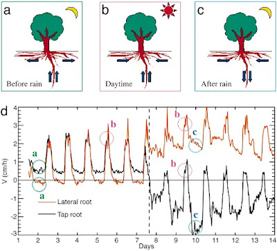
Below is an animated illustration off Todd Dawson's Lab sitewhich beautifully illustrates just what happens during daylight hours, nighttime and even during the rainy season when trees and shrubs are in dormancy state.
Animated imgage - Dawson's Lab
Sap velocity in the taproot and lateral root of P. robustum during the transition from the dry to wet season in the Floresta Nacional do Tapajós.(a–c) Schematics for water movement at nighttime before the rain (a), daytime before and after the rain (b), and nighttime after the rain (c). Arrows shown the dominant flow direction determined by sapflow. (d) Graph showing sap velocity. Positive values mean that water flows to the plant, and negative values means away from the plant into the surrounding soil. The dashed line represents a rain event (36 mm). See the text for a complete explanation.
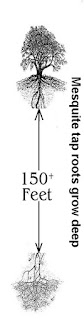
One of the first articles I ever read was a piece done above Todd Dawson'sresearch work on the role Sugar Maple (Acer saccharum)play in it's temperate forested ecosystem. It was exactly similar to something I had read about desert tree called Honey Mesquite (Prosopis juliflora) grows to a height of up to 12 metres (39 ft) and has a trunk with a diameter of up to 1.2 meters (3.9 ft).
Its roots are able to grow to a great depths in search of water: in
1960, they were discovered at a depth of 53 meters (175 feet) at an
open-pit mine near Tucson, Arizona putting them among the deepest known rootsystems.
"Mother Nature's Irrigators" by Todd Dawson
Of course I already had an interest on the theories and research work by an Austrian Forester and self taught Physicist Viktor Schauberger. This Schauberger spoke of healthy electrically charged water as only coming from deep within the Earth and moving upwards through the soil bringing with it along vital nutrients (or Salts as he put it) which nourished plants and other life on the surface in the process. The invaluable research work and physical naturalistic explanations provided by Todd Dawson, his team and a plethora of other modern day researchers was sadly something unavailable to Viktor Schauberger who was privileged to live at a time when most old growth forests were still intact and in their pristine state and he could observe first hand natural phenomena that we can only dream of now. With that early research in the back of my mind, this paragraph from the above linked article that caught my eye. It suddenly made sense of some of the things that seemed so mysterious. Take a look at what Todd Dawson and his team discovered with regards streamsidetrees. One would think that all that lush growth draws it's water hydration from off the surface waters. But not so. Read this one paragraph from the link from:
"Mother Nature's Irrigators"
"By comparing variations in isotopic concentrations taken from different sources, they were able to show that mature streamside trees do not use stream water but used deep groundwater. When Dawson came to Cornell in 1990, he looked for ways to combine his research in water use with his interest in woody plants and their distribution and physiology. During the summers of 1991and 1992, Dawson observed the water use of Maples."
Todd Dawsonmade a further research work of this streamside (Riparian Habitat) water use by Trees. These trees amazingly prefer the deep groundwater to the surface water abundant in what appears to be a healthy surface water situation. Take the time to read the paper they did on this in the link title:
"A LONG-STANDING axiom is that plant distribution is strongly influenced by soil moisture content1,2. While it has been shown that plant taxa inhabiting streamside communities receive or use more water3, it is assumed that this water is obtained from the stream adjacent to where they are found growing. Here we show, using hydrogen isotope ratio analyses at natural abundance levels, that mature streamside trees growing in or directly next to a perennial stream used little or none of the surface stream water. The deuterium to hydrogen content of both source and xylem waters indicated that mature trees were using waters from deeper strata. Although adult trees may have roots distributed continuously throughout a soil profile, it seemed that the most active sites of water absorbtion were limited to deeper soil layers. In contrast, small streamside individuals appeared to use stream water, whereas small non-streamside individuals used recent precipitation as their primary water source. Our analyses provide both a relatively non-destructive method for assessing water sources of plants and a means of assessing potential competitive interactions among cooccurring taxa. In addition, the method may aid in resolving the role of water in determining plant distributions in areas characterized by sharp soil moisture gradients."
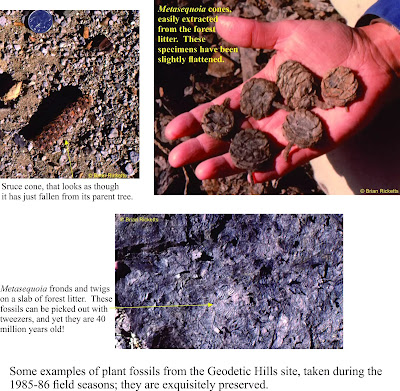
The above info has intrigued my interest because of my passion for finding evidence for an Ancient Earth's minerotrophic hydrological cycle which no longer exists on the Earth for the most part, though it does in parts such as Fens or Sahara Oasis where rain is not a factor. There are hints and clues everywhere and the technologies we can develop from learning about these natural processes are incredible and vitally important given the sad state of health conventional science has brought to mankind and the world around them. A huge discovery in the Arctic (Axel Heiberg Island) of ancient Dawn Redwood trees where actual wood which is not fossilized, but rather well preserved and mummified has provide Chemical Signature clues through Oxygen Isotope study as to the origin and source of water which hydrated those trees. Here is a sort quote of one researchers, Hope Jahren, in an interview of their finding of an ancient climate's past.
"Because the wood is unadulterated, the tissues hold a chemical record of weather patterns during the period the tree lived. Jahren studies carbon, hydrogen, oxygen, and nitrogen because these elements are taken from the soil, water, and air and incorporated into the tissue of plants and animals.
Jahren and her colleague Leonel Silveira Lobo Sternberg of the University of Miami in Coral Gables, Florida, are examining chemically different forms, or isotopes, of oxygen in these ancient redwoods to reveal weather patterns during the Eocene period.
Oxygen that a plant uses, said Jahren, comes primarily from water. Determining the chemistry of that water could reveal exactly where it came from. Rain that arrives after traveling long distances over land has a very different chemical signature than rain that travels over the ocean or just very short distances, she explained.
The researchers' analysis of the oxygen content of the wood revealed "a bizarre absence of oxygen-18, the heavy isotope," said Jahren. Water contains both oxygen 16—the more common and lighter isotope—and the more rare oxygen 18. The analysis suggests that the water contained almost exclusively oxygen 16."
National Geographic TodayMarch 26, 2002
"Arctic Redwood Fossils Are Clues to Ancient Climates"
Take a further 26 minutes if you are able and view this video on the Quest science video which tracks the field work of Todd Dawsonand his team. They take a look at our present hydrological water cycle and proceed to study just how it actually does work. You might say they are taking a more detailed approach by focusing in on the fine tuning of this hydrological cycle that is not necessarily observable the the average person. In fact Todd Dawson reveals more fresh water is store within the earth than on surface. Of course fast forward and this may not be true anymore. As the video's descriptive reference on the page states,
"Scientists at UC Berkley are embarking on a new project to understand how global warming is effecting our fresh water supply. And they are doing it by tracking individual raindrops Mendicino and north of Lake Tahoe."
Here is the video link which is only about ten minutes long. Enjoy!
"QUEST: Life of a Raindrop"
The animated illustration at the top of this page which shows the various functions of the phenomena called Hydraulic Lift & Redistribution comes from a paper Dawsonand other researchers did called,
"Root Functioning Modifies Seasonal Climate"
Abtract:Hydraulic redistribution (HR), the nocturnal vertical transfer of soil water from moister to drier regions in the soil profile by roots, has now been observed in Amazonian trees. We have incorporated HR into an atmospheric general circulation model (the National Center for Atmospheric Research Community Atmospheric Model Version 2) to estimate its impact on climate over the Amazon and other parts of the globe where plants displaying HR occur. Model results show that photosynthesis and evapotranspiration increase significantly in the Amazon during the dry season when plants are allowed to redistribute soil water. Plants draw water up and deposit it into the surface layers, and this water subsidy sustains transpiration at rates that deep roots alone cannot accomplish. The water used for dry season transpiration is from the deep storage layers in the soil, recharged during the previous wet season. We estimate that HR increases dry season (July to November) transpiration by ≈40% over the Amazon. Our model also indicates that such an increase in transpiration over the Amazon and other drought-stressed regions affects the seasonal cycles of temperature through changes in latent heat, thereby establishing a direct link between plant root functioning and climate.
From time to time I will add to this page further research done by Dawson and other who vision along the same line of thought and discovery. Keep checking for updated page.