Showing posts with label climate. Show all posts

Thursday, February 16, 2017

Heavy Winter precipitation in the Western United States is apparently meaningless

Is the California drought finally over ??? Incessant rainfall and snowfall leads to terrific flooding in the Golden State as thousands of homes are evacuated 
Image from The Daily Mail
But officials also warned that though the rain has eased conditions, the drought isn't completely over

The average person falls for the big Media bluff that all is well when weather conditions take an apparent turn about from the long hard drought. Especially when it's an extreme turn of events like the massive snowfalls and rain flooding events presently hitting California and other western regions. In the back of people's minds they are telling themselves things are back to the good ol'days. But now after Californian's have been praying for rain for five years, now they are praying for a break in the rainfall. Perhaps they may believe what the UC Merced Hydrologist Roger C. Bales theorized was correct after all. Get rid of all those greedy water sucking trees and streamflows will rise. Less trees gulping water means fuller streams. Not so fast. Most of that so-called science about removal and thinning of Sierra Nevada Forest trees was more of a public relations stunt funded and backed by the giant Timber Industry and down stream Industrial Agriculture business interests which has a love affair with massive flood irrigation methodology. The imaginary myth was theorized that less forest trees gulping down water would translate more water in streams and rivers filling up reservoirs. While I looked for research on any type of documentation of millions of dead trees actually proving this reverse phenomena to be true a couple years ago, I hadn't found any until now. Apparently the research had been there a little over a year ago, but got very little success in attracting Media attention. Not as sexy as Roger Bales and Michael Goulden's theories I guess.
Recent tree die-offs have had little effect on streamflow in contrast to expected increases from hydrological studies
Images from Nature.com

Clockwise from top left the photos are Spain, Colorado, New Mexico and Argentina.


We've all read the stories and seen all the horrific  photographs of what Mountain pine beetles have done to the western forests over the past decade due to hotter temperatures and drier summers. These bark beetles have infested and killed  thousands of acres of not only western pine forests, but other forests around the globe are now also in trouble as well. Researchers like Roger C. Bales (UC Merced) and Michael L. Merced (UC Irvine) have previously predicted that as trees died or were mechanically removed by logging and thinning, streamflows would increase because fewer trees would be greedily gulping up water through their roots and transpiring it up into the atmosphere. In the imaginations of the Hydrology boys, less trees equate more water runoff for agriculture down in California's Central & San Joaquin Valleys. Back in December 2015, a study by  the University of Utah geology and geophysics professor Paul Brooks and his colleagues in Arizona, Colorado and Idaho, found that if too many trees die, then compensatory processes would kick in and might actually reduce water availability. This is the exact opposite of what Bales and Goulden speculated would happen. But what Brooks and others discovered is that when large areas of trees dieoff, the forest floor becomes sunnier, warmer and windier, which causes winter snow and summer rain to evaporate rather than slowly recharging groundwater. In fact in describing what happens with the snow which usually melts and slowly percolates into the ground, what actually happened was a phenomena called "sublimation." This process of sublimation is where snow and ice change into water vapor in the air without first melting into water. The opposite of sublimation would be "deposition", where water vapor changes directly into ice (such a snowflakes and frost). So what happens with much of that heavy snow we've seen in recent photos does not all melt and infiltrate into the subsoil layers, but rather a good percentage of the snow evaporates up into the drier warmer atmosphere. What is interesting is that the regions studied were much of the high elevation headwaters areas for the Colorado River which fill down stream reservoirs like Lake Powell and Lake Mead which have been experiencing rapidly falling water levels. This effects water potential for Arizona and Southern California.
Abstract:
"Recent bark beetle epidemics have caused regional-scale tree mortality in many snowmelt-dominated headwater catchments of western North America. Initial expectations of increased streamflow have not been supported by observations, and the basin-scale response of annual streamflow is largely unknown. Here we quantified annual streamflow responses during the decade following tree die-off in eight infested catchments in the Colorado River headwaters and one nearby control catchment. We employed three alternative empirical methods: (i) double-mass comparison between impacted and control catchments, (ii) runoff ratio comparison before and after die-off, and (iii) time-trend analysis using climate-driven linear models. In contrast to streamflow increases predicted by historical paired catchment studies and recent modeling, we did not detect streamflow changes in most basins following die-off, while one basin consistently showed decreased streamflow. The three analysis methods produced generally consistent results, with time-trend analysis showing precipitation was the strongest predictor of streamflow variability (R2 = 74–96%). Time-trend analysis revealed post-die-off streamflow decreased in three catchments by 11–29%, with no change in the other five catchments. Although counter to initial expectations, these results are consistent with increased transpiration by surviving vegetation and the growing body of literature documenting increased snow sublimation and evaporation from the subcanopy following die-off in water-limited, snow-dominated forests. The observations presented here challenge the widespread expectation that streamflow will increase following beetle-induced forest die-off and highlight the need to better understand the processes driving hydrologic response to forest disturbance."
(Source)
Tree mortality is increasing worldwide which also includes Canada
Image - Natural Resources Canada
Tree mortality is increasing worldwide including Canada
"Tree mortality will likely increase in areas where extreme weather events become more frequent. Climate change projections indicate that in some parts of Canada, droughts and other extreme events are expected to become more frequent in the future. These changes could trigger increases in tree mortality and episodes of forest decline in affected areas, posing challenges for forest management and the long-term supply of forest resources and services, including carbon balance."
So just how well are all these forests regenerating on their own without mankind's help and interference ??? Despite Environmental Activist insistence that this is the only way Nature can heal, in almost all cases the natural world is failing!
Image - University of Colorado Boulder

Researcher Monica Rother at the site of the 2000 Walker Ranch fire in Boulder County.
Eighty percent of plots surveyed there contained no new trees.
The studies and observations by the researchers from the University of Colorado Boulder exposes the bleak reality. It makes sense though. Trees under extremely high stress from drought, pine beetle attacks and catastrophic wildfire events will dump most of what's left of their energy resources into defensesive strategies (Survival) and very little towards offensive strategies (seed production). Here are a few excerpts from the report:
“It is alarming, but we were not surprised by the results given what you see when you hike through these areas,” said Rother, who earned her doctorate from CU Boulder in 2015 and works as a fire ecologist at Tall Timbers Research Station in Tallahassee, Florida. 
Among the most barren sites were those of the 2000 Walker Ranch fire in Boulder County and the 2000 Bobcat Gulch fire in Larimer County, where approximately 80 percent of plots surveyed contained no new young trees.  
“This should be a wake-up call, that under the warming trends associated with human-caused climate change, significant shifts in forest extent and vegetation types are already occurring,” said Veblen. “We are seeing the initiation of a retreat of forests to higher elevations.”  
Previous research has suggested that hotter, more severe fires make it harder for the forest to bounce back by killing mature trees and reducing seed stock. But the study found that even after lower-intensity fires, presumed to have had less effect on mature trees and seed stock, seedlings were still scarce. Hotter, drier areas at lower elevations or on south-facing slopes had the fewest seedlings.  
“Fire severity is definitely relevant, but climate appeared to play the greatest role,” in limiting forest recovery, said Rother.  
“I don’t want to present this as being entirely negative,” said Veblen. “For me, the negative aspect is what it indicates about the future.”
(Source)
So the main thrust of the message from this report is that it now seems that Nature is no longer able to restore itself in many areas. Humans have done so much extensive damage that it is also necessary for them to actually intervene and mechanical help Nature. The protesting and politically motivated wilderness designation or Nation Park status will never work. Unfortunately most people (& this includes Scientists) do not have the full understanding of how the natural world functions and operates. Much of our understanding and progress has been held back and stuck in neutral because of of silly ideologically driven worldview as mandated by this world's Scientific Orthodoxy which controls the prevailing scientific thought which has infected all Academia. Way too much time and energy has been spent by Academia and environmental organizations on religious concepts such as (Argument from Poor Design) to battle against what they call religious fundies. The argument basically trashes numerous components of our planet's natural world as being flawed, imperfect and badly designed. The argument then promotes the lame idea that this is proof there is no creator because an intelligent designer would never have created or engineered things in such & such a way. Hence, instead of creating technological innovations which apply biomimicry or biomimetics (replicating natural designs when it comes to technological innovation by observing designs found in Nature), our world's intellectuals have instead pursued innovation based on flawed human reasoning and understanding. This is what has brought us much of the genetic engineering in agriculture and a plethora of dangerous toxic synthetic chemicals to deal with the imbalance in pest invasion that humans ultimately caused in the first place. Nature have never worked that way and nature has kept balance for countless 1000s of years without human interference. Suddenly now there are some Biomimicry organizations who are on board with replicating natural designs, but they have to first undo deprogram all the people who have been fed the prevailing secular koolaid and then re-educate people as to how nature really works. This is not so much a slam against the worldview obsessed as it is a wake up or shake up call for people everywhere, irrespective of your belief system, that nature no matter how one believes if origined, has never been flawed, imperfect or badly designed. This is where flawed thinking brought California the inept theory of tree removal bringing us more water. Do you see how this has now backfired ??? Here is another example of how Forest ecosystem failure and collapse needs human intervention from India:
In order to restore tropical rainforests, it is not enough to simply set up protected areas and leave them to their own devices. In particular, tree species with large fruit and seeds distributed by birds will have to be actively planted. This is one of the conclusions of a large-scale study by scientists from ETH Zurich in the Western Ghats, the mountain range running along the western coast of India. 
“For rainforest restoration projects to be successful, you have to give special attention to these trees,” says Kettle. “If you want to encourage them to spread, the only option is to collect their seeds, set up tree nurseries and then actively plant out the saplings at a later stage.”
(Source)

Nature is becoming less resilient and no longer able to sustain itself as it has done for countless 1000s of years. One disappointing thing about the study of dead trees not increasing stream flows was the silence on the phenomena known as "hydrological descent" in which living trees (also shrubs), even when dormant, which pump excess surface water during the rainy season down into deeper layers of the subsoil layers helping to recharge the water table aquafirs. That should have been included in this study and it wasn't. Can you imagine what low percentage of this California rainy season's (2016-2017) precipitation has actually percolated into the California landscape and how much has blown out back into the Pacific Ocean through massive flooding runoff ? After years of drought a lot of bare ground will almost fossilize to where the soils pores will close up tightly and the phenomena of capiliraary action needs time to heal properly. The state of California has no infrastructure in place to funnel massive amounts of this excess freshwater back towards the interior desert riparian habitats. Think of aquatic environments like Mono Lake, Owens Lake and further south the Salton Sea which already has a major ecological water problem. Or how about any of the other maze of dry lake beds throughout the Mojave Desert. Could such filling of these large natural basins have a moderating effect on the state's regional, if not statewide climate and weather ? Not to mention benefits to wildlife ? According to all of the above studies we just briefly touched on, humans are going to have to actually intervene now and make the necessary corrections. Instead of dumping money and manpower into ineffective angry protest and destructive civil disobedience, people need to go beyomd clicking "LIKE" on a Facebook page article about environment and physically get out doors and start restoring ecosystems based on natural design which was never ever flawed. However, how well historically has that been working out for us ??? 
Can collective groups among mankind  really work together to reverse these trends we've just read about ???


We all know how well it turned out for Humpty Dumpty. All the King's horses and all the King's men were unqualified and ill equipped to fix anything back together again. Governments, Business Leaders, Scientists & Religious leaders likewise do not have the answers nor the management skills we need for a real world viable solution either. The common people around the world are taking to the streets in a last desperate resort in protest and they too are likewise ill equipped to put anything back together again. The people protesting are often not exactly sure of what they are protesting about when interviewed by some in the media. It doesn't matter what they are protesting, or what message is on their signs because they are usually are nothing more than hollow slogans. And this is taking place most everywhere globally. Fixing and correcting things takes real cooperation and working peacefully together. That's not how this world we're all forced to live in works presently. Even today's angry environmental movements seem to have no answers other than protesting something or someone they hate. They never really offer any viable alternatives other than kicking other people off a piece of some sacred real estate and saying, "Nature will just find a way" to heal itself. In the studies above that will not happen. Each and every day, Salman Rushdie's word in that CNN interview ring true:


"Classically, we have defined ourselves by the things we love. By the place which is our home, by our family, by our friends. But in this age we're asked to define ourselves by hate. That what defines you is what pisses you off. And if nothing pisses you off, who are you?" 
Salman Rushdie
There really are some decent organizations out there that actually go beyond hate motivated protesting. They also demonstrate how energy is better spent educating the public in following natural design and in participating in hands on habitat restoration work. One of the main organizations that comes to my mind is the group, (Back to Natives Restoration) who actually provide a valuable service to local urban communities and in education work to the public. Same can be said for other native plant nurseries like (Las Pilitas Native Plant Nursery) and (Tree of Life Native Plant Nursery) who offer not only healthy viable native plants, but also extensive educational programs to help enlighten their customers and general public as to how nature really works and replicating installation and care with less water and no industrially manufactured science-based synthetic (fertilizers & pesticides) chemicals. All these organizations are strictly founded and identify themselves based on something they truly love, not something they hate or what pisses them off.
In Conclussion
At the very least we know where things really stand concerning our Earth's environment when the media attempts to paint a rosy picture of things not being all that bad as we first thought. It's worse folks. We also now know for a certainty that all those Politically motivated and Industrial Business interest funded hydrological studies conducted at several California Universities were dead wrong from the start. In fact their flawed schemes were never close to the truth, but many of us already knew that.


Wednesday, June 29, 2016

Ascension Island's Green Mountain Cloud Forest Created by Mist ?

Genesis 2:5-6
"No bush of the field was yet on the earth and no vegetation of the field had begun sprouting, because Jehovah God had not made it rain on the earth and there was no man to cultivate the ground.  But a mist [fog, vapor] would go up from the earth, and it watered the entire surface of the ground."
For the moment before you freak out about the quoted text from Genesis, dump all the secular ideological baggage against the source referenced above and focus here for a change. I'll explain why I quoted this text above from Genesis down below at the bottom of this post. There are whole plant ecosystems around the Earth which are not necessarily hydrated by conventional storm systems we are all familiar with, but rather from a hydrological phenomena originating from fog, vapor or even a mist. I've written about some of these in the past such as Ascension Island, Canary Islands and even minerotrophic systems such as those that receive no rainfall ever like large Oasis in the Sahara of North Africa which predominantly are hydrated by means of underground springs. Yet the plants within those ecosystems do thrive and replicate themselves. Here is an update on some things I wrote previously about Ascension Island.
Climate Change and "Ascension Island" (Ideology trumps Reality)

Photo by Meg Wilkie
The photograph above is of a man made pond create near the top of Green Mountain on Ascension Island. There are water Lilies and some tiny goldfish in the pond. This pond was constructed near an area ravine which was historically given the name Dampiers Drip. It is kept filled not by normal precipitation such as rain, but rather cloud forest condensation, fog, mist, vapor etc.

image: Ascension-Island Government

On a Remote Island, Lessons In How Ecosystems Function

Lanzarote National Park of Timanfaya

Canary Islands
Ascension Island is near St Helena in the Southern Atlantic Ocean between Africa and South America. Right west of Angola if that gives some reference for you. The island wasn't always looking like the big green lush photograph you see above. It looked a lot more like on of the volcanic islands of Spain's Canary Islands. When Charles Darwin visited Ascension Island in 1836 on his voyage with the ship Beagle, he declared it to be "naked hideousness". But it was British Botanist Sir Joseph Hooker, who had the bright idea of planting trees on the mountains which would bring more rainfall. His idea or scheme is what the researchers call "Terra Forming."  The raw canvas both these men saw was much like the smaller photo to the right with volcanic rock, lifeless looking soils and very little life other than maybe biological soils crusts. Mostly lichens, mosses, algaes and ferns. No indigenous or introduced & naturalized shrubs or trees anywhere. I wrote an article about another article on Ascension Island which I will reference in a link below of this beautiful green island picture at the top. What appalled me were the critics of Fred Pearce's article on lessons we can learn as far as ecosystem function. You see in Ascension's early history, there were no ponds, springs or streams. There was no real fresh water source anywhere when the British outpost was first set up on the island. There was one small spring, but it was remote and couldn't support any human settlement. Most all water and other supplies had to be brought in by ship. In this time of dire climate change, it was a golden opportunity for scientists and other researchers to come and study plant community mechanisms on what creates cloud formation, moderates weather and causes precipitation. Keep in mind that this island's transformation has taken place in little over 100 + years. However, I kid you not, very few Scientists are interested in studying this transformation and weather mechanism, why ? 

Image: BBC News

Conservation Officer, Stedson Stroud
finding a supposedly extinct Fern
Mostly the vicious criticism came from ideologically driven EcoActivist Groups who freaked out over the Island's non-native invasive plant species which totally fogged the real issue here and that is how to reverse climate change and repair our damaged Earth. There is no argument that invasiveness and a screwed up planet in general can be found everywhere. Numerous things were done many many years ago which we can not do nothing about, but what these people were missing was the climate driving mechanisms of the Acesion Island forest. The other argument was that existing endemic species had disappeared or were going extinct. The photo to the left here is of Green Mountain's Conservation Officer, Stedson Stroud, who found what was insisted upon to be an extinct Fern. The volcanic island prior to human influence was once sterile looking true desert island from a visual point of view other than small plants and biological soil crusts. But it's this artificially introduced vegetation growth that apparently offends many of this  Ideologues for nothing more than blind faith reasons. Once again just to repeat, prior to these introduced plants, the island was mostly a collection of Biological Soil Crusts [bacteria, lichens, mosses, algae, Ferns, etc]. But you cannot communicate anything with these types of people whose view themselves as the only ones qualified as keepers of all knowledge and any understanding on how our Earth works. Their precious hallowed topic (biological diversity) is generally considered their prerogative. Any understanding must first go through them. I once got myself in hot water about a year and a half ago when a person from a desert protection ecology group posted a photograph of their favourite outback Badlands spot at the Anza Borrego Desert. I made an innocent comment about how many people would view such a place as nothing more than a desolate wasteland, but I saw it as having great future potential. I merely meant potential in creating an environment of a healthy viable desert plant community which would further benefit all manner of other desert wildlife. But the commenter was outraged and I was hammered.

In their view, it was perfect as is and any thought of even desert plants, animals and birds thriving there was repugnant. Whatever people!  It wasn't even worth giving a response. Things are not as bad on the Ascension Island as the outraged scientists want us to believe, who would rather the plant life be removed. Seriously, you have to read it to believe it. Actually, I've written Stedson and he has been busy with tough job of keeping under control one of the native plants from the Southwestern United States, Mesquite, which has spread by seed by wild feral Burros. He also has had to keep up with capturing and removing over 500 cats which were killing off the native sea birds and their young on the plains below. So clearly some things need correcting. I wrote to Stedson a message and thanked him for his hard work and to keep it up despite the vicious criticism they received. He responded with this: 
"Thank you kindly for those words above, I sometimes feel let down and used by the very people I have helped and trust. But as a committed conservationist, I keep going, earlier this year I discovered a new algae and a new to science fungi in a sea vent on the South East coast of Ascension."
Of course not all is lost as much of the alarmist fear mongering insisted would happen. Below is a short paragraph from another article about Ascension Island back in December 16, 2010
"Beneath the summit ridge on Green Mountain, on the lawns of a small garden, Mr Stroud nurtures indigenous plants. He discovered one fern only a couple of years ago—a species hidden for centuries. He plants the successes under a huge fig tree on the ridge. When they flourish he takes them further out into what on other islands would be the wild, but here is the artifice, returning occasionally to check up on them and take more seed. While he and his successors are here, those ferns and grasses will be safe from extinction. And a few are taking the initiative themselves. Xiphopteris ascensionis, a tiny endemic fern, had never seen a tree before the Victorian planters came. Now it lives in and on them, nestled in their moist bark, pioneering the epiphytic way of life familiar from ancient forests around the world and discovered afresh in their youngest cousin. Life, with helping hands, adapts."
(Source: BBC)
Below are a couple examples of the Endemic Natives successfully mixing and taking better advantage provided by the non-native invasive plants which have provided further opportunity for them to excel and thrive more so than previously. I know many out there from the ideologically driven purist gang (Center for Biological Diversity, etc) don't want to hear or see such success stories, but to quote one of their own hallowed blind faith afirmations, "Life Finds A Way." First, take a close look at the Mist/Fog Pond near the top of Green Mountain. Near the summit of this Green Mountain  is the Dew Pond which is actually kept filled with water captured from plant foliage from the Mist/Fog that moves across the landscape from the surrounding Atlantic Ocean, constructed in 1875. There are water Lilies and some tiny goldfish in the pond. I believe the pond was constructed near an area ravine which was historically given the name Dampiers Drip.


image: Arkive.org

Fern (Xiphopteris ascensionensis)
The photos above and below are of the interactions between the so-called escaped invasive plants and the endemic mosses and lichens which outraged eco-activists says would all go extinct as a result of the introductory species. But it hasn't worked out that way. No doubt Phenotypic Plasticity and Epigenetic Gene Expression influenced by newer   Environmental Cues allowed these endemic plants to engineer and adapt themselves within a symbiotic relationship on their new host plants.

image: Arkive.org

Fern (Xiphopteris ascensionensis) and Moss
most likely on a Laurel tree branch

Some Further Reading Reference on Ascension Island
On a Remote Island, Lessons In How Ecosystems Function
The Economist: "Another green world"
(2012) Team Member Stedson Stroud – Saving Ascension’s wildlife
Ascension Island - plant restoration
http://www.kew.org/press/images/Anogramma_ascensionis.html

Another interesting paper co-authored by Stedson Stroud of the Conservation Depart. of Georgetown on Ascension Island and David C Catling from the University of Washington
University of Washington, Seattle, Wash: "The Greening of Green Mountain, Ascension Island"
So where does all of this leave us now ? 
The subject of Climate Change is all over the Global News, but what you won't find in the Nightly News are success stories of how Nature drives and maintains climate on Ascension and Canary Islands.And when News Journals do draw attention, it's merely a token acknowledgement nature story as something of local interest and then shelved away. The actual education of John Q-Public of the interesting biological mechanisms which make the whole climate thing a success never rakes place because demonizing one's political opponents and their worldview is generally the goal. Once again, this subject should be in the main stream news. But it's not, other than the political back biting and positioning one team over another. The questions that are not being asked here are, "What are the mechanisms which make the global climate function, what creates clouds and moderates the weather, how does rainfall and other precipitation really occur and what do plants have to do with that ?" But we don't get such questions or their answers. There are plenty of other examples like Easter Island where uncontrolled deforestation hurt the population in the end. Other examples of desertification in Africa and the American southwest as the result of plant communities being obliterated for short term profit potential could be helped once again to a recovery by further research and understanding of how these mechanisms function. If vegetation removal causes less rain and mega-droughts, shouldn't replanting reverse that ? 
Occult Precipitation (Oxford Reference) ??? ☂☂☂
Photograph: Miguel Sequeira
Interestingly there are several scholars who have shown that, on the island of Madeira (Portugese island in the Atlantic), that the water fog collected by vegetation – the occult precipitation – constitutes an important component of their hydrologic system, reaching, under ideal conditions, more than 60% of the total water that annually falls in the forest ground. Take the example here on the right of droplets of occult precipitation (fog mist) in this tree heath – Erica arborea on Madeira Island. There is an interesting dictionary definition given on the term "Occult Precipitation", which defines the mist or fog rain phenomena as a form of precipitation which cannot be measured, then just how much of that mystery water have many areas actually lost during this climate shifting ? If most of the measurable rain records show major declines, how much more so of this un-measurable precipitation has been lost if we could actually put a number on it ? Nobody seems interested enough to ask. Clearly, some of these Fog or Mist capturing devises should be transformed into remote weather stations for monitoring in certain areas for measurements of marine layer precipitation. 
Cloud water interception in the high altitude tree heath forest (Erica arborea L.) of Paul da Serra Massif on Madeira 
Animation - Research Gate
References for Cloud Forest Precipitation
Cloud Water Interception in the high altitude Tree Heath Forest Erica arborea L of Paul da Serra Massif Madeira Portugal
Occult Precipitation on Madeira Island
But what about all those other Myths, Fables, Storytelling historically condemned by the prevailing Scientific Orthodoxy ???
Throughout the 20th century, there have been many stories or legends about natural phenomena which were written or spoken about in ancient times by various cultures and peoples who for the most part have been regarded as mere superstitions, myths, fables, etc by today's various intellectual elites. But I have always been really intrigued and curious about what real natural world phenomena they were first hand eye witness observers to and from which they could only explain things based on their limited knowledge of things like science. For example, about a month ago I watched a science documentary about the first discovery of many of the new animals originally found and documented by scientists in Australia when Europeans first colonized. There was debate over whether Duckbilled Platypus actually laid eggs or gave live birth. The Aboriginal natives had told the White Europeans that the Platypus laid eggs, but this was discounted as a fable and myth, because these peoples were illiterate, ignorant, primitive savages and what could they possibly know that a white European scientist couldn't discover and verify. Until that happened, such a thing was ridiculous. As it turned out such official verification and discovery was up to British Scientist William H. Caldwell. Click on this link and read the first short paragraph under introduction. It verifies what the BBC documentary I watched said: 
"The central narrative of this paper is the 'discovery' by British scientist W H Caldwell that monotremes (platypus and echidna) lay eggs. The famous telegram 'monotremes oviparous, ovum meriblastic' (monotremes lay eggs of the same sort as reptiles), sent to the British Association for the Advancement of Science meeting in Canada in 1884, put to rest a debate about whether platypus laid eggs or had live young that had raged throughout the century. The story reveals much about the imperial shaping of scientific knowledge. Observers in Australia and Aboriginal informants, who had asserted that platypus laid eggs, had been disbelieved. 'Discovery' was reserved for Caldwell, a British scientist of impeccable scientific lineage."
(Source)

Another interesting natural phenomena which in the past hasn't receive much press or given much acknowledgement is the incredible phenomena of Mushroom or Truffle formation by mycorrhizal fungi almost not long after Lightning Storm occurrs. The Romans and Greeks both recorded such observations, but these have been condescendingly dismissed by most Scientists as myths or fables if you've tried to research the literature. The accounts have been categorized under what are a part of the Roman and Greek Mythologies. Then of course there are also the Bedouins of the Negev who call these desert truffles ‘the thunder fungus’ and so do other African peoples who search for the Kalahari Desert Truffles after lightning storms. But I've also known of this from personal observation back in the 1980s when I would go out to search for Pisolithus tinctorius mycorrhizal truffles. Certainly many would appear in Spring, but especially after the Monsoonal Thunderstorm season hit Anza California starting around the first of July. Almost two weeks after the heaviest Thunderstorms hit our area my favourite collection areas would provide a mother-lode of them. They are edible and sometimes they would still be a fresh white colour, but I wanted dried truffles for their spores for inoculation of my plant's rootsystems. So I waited a while for them to age. The main point is, while I always knew the location, I never knew the when until after Lightning Storms. Here is a previous post of mine where I providedreferences giving some legitimacy to what the Experts have labeled myths about truffle formation after lightning storms.
Snap, Crackle & Pop!, Rumor has it that the Lightning gods make the Mushrooms (truffles)
Then of course there are what many would call the biblical creation myths. Okay, I get the arguments and dislike Secular Scientists & their modern day IFL members have against Christendom. Frankly, I don't care for many of their beliefs or their historical atrocious conduct either, but the newer 20th & 21st century enlightenment Free-Thought Gang hasn't exactly managed the world's affairs any better since they began asserting their own version of religious Orthodoxy's influence over the world's affairs. Pushing that baggage aside for the moment, let's go back and look at the referenced verse 6 of Genesis 2 below and read it.
Genesis 2:6 - Amplified Bible
 "But there went up a mist (fog, vapor) from the land and watered the whole surface of the ground"
This scriptural text has always intrigued me since the early 1960s when it was first read to me. Why ? Because it's odd, it's not normal, sounds crazy and out of touch with today's reality as I understood normal hydrology and climate. In other words, I've only understood rainfall coming from an actual storms off oceans, moving over land masses and dumping rain. Still, in view of how other peoples have been treated in the past by so-called intellectuals which were proven wrong, could there really be any shade of truth to this description by ancient peoples from a time period in which our natural world's climate driving mechanisms were more intact, even if this were only a mere unexplainable observation ? So I asked myself, could this original writer have also been recording information as he actually observed it back several thousand years ago ? So was this writer recording phenomena occurring as it was normal and common to him and others thousands of years ago ? Ultimately I really have no idea to be sure. But the location where these texts  were written down was in the Sinai Peninsula which is right next door to where moisture is observed hydrating the various ecosystems within those western Saudi Arabia Mountains today next to the Red Sea. Once again I still have no real clue, and it was this puzzle got me interested more and more in just how plants could hydrate an entire community through a mycorrhizal fungal networks under pristine healthy vegetative conditions which would have been more common then in ancient times thousands of years before our planet with it's present 8+ billion humans who have mostly defoliated this Earth. What we can acknowledge is that the present mist or fog precipitation phenomena didn't always occur on Ascension island prior to the introduction of Trees, Shrubs and other plants. But now at present it does occur as a result of the trees and shrubs which took over and created a cloud forest. Also we know now that desertification does indeed occur when vegetation is removed from an environment. Given the fact that far less humans existed at that time period and more healthy vegetative systems were most likely in existence 1000s of years ago than today, it could be reasonable to assume such a common hydrological system was real at one time.


Even Austrian Forester and Physicist Viktor Schauberger (1878-1958) who wrote extensively about water and often tried to describe a phenomena of upwards movement of water (soil's natural capilliary action) within healthy old growth forests by attributing such phenomena to some sort of mysterious energy, had the prevailing scientific community of critics who thought he was a crackpot. How could he possibly have ever known what we do today about old growth forests incredible ability at Hydraulic Lift and redistribution ? But he did however make observations of pure clean water springs and brooks disappearing after old growth forest trees were cut down. He attributed it to the sun having a negative effect of draining power away from the naturally occurring energized water as he called it. Today however we know far more than he did and yet he was correct that such a phenomena did indeed exist. We do know about hydraulic lift and redistribution. We do known the phenomena of a soil's capillerary action with both upwards and downward movement of water. This phenomena is further enhanced by other phenomena by deep rooted Trees & Shrubs in what is known as Hydraulic Lift & Redistribution & Hydraulic Descent. While much research into both of these has been undertaken by some researchers, the public in general is oblivious to most of this infavour of conventional science. The main problem with today's intellectual movement is that they will automatically discount such phenomena for no other reasons than they hate of the messengers. That's irresponsible, but clearly throughout time, this has been the historical precedent. How many important discoveries have been stifled because of the condescending arrogance by the ruling elite Scientific Orthodoxy which controls most thought in our world today ? At least for the people who know me and what I am talking about, this phenomena and other intriguing complex networked functions which move and provide moisture to sustain ecosystems, this gives hope and promise that based on many of these facts, that our earth can be biologically repaired and made a more sustainable place in which to reside. The only thing that stands in the way is proper leadership around the globe. As time pants on to the end, count on this leadership getting weirder and weirder. This doesn't let the whole of Christendom off the hook either for their refusal to denial of global climate change because they involve themselves within a certain specific segment of rightwing politics which is opposed to leftwing secularism:
Matthew 24:37-39 - A warning message of 'Climate Change' & the consequences of "Apathy" ?
Still, for the moment, people can still decide what to believe and make practical application where important. Take special note of something I wrote about yesterday which can speed up the process.
Groasis Waterboxx: Desert Greening, Root Infrastructure Development, Water Savings, Teaching Kids Nature, etc, etc, etc


Sunday, October 6, 2013

(Part 1) Juan Bautista de Anza's Journal sheds light on a past Extinct Ecosystem

The Trek from Western Arizona ending at the San Carlos Pass (Terwilliger)
Credit: Cartographer Karl Musser
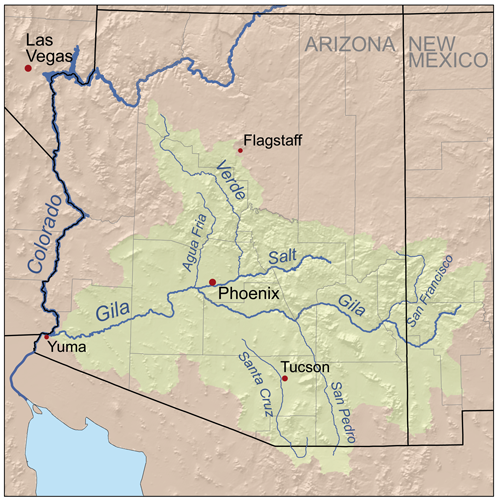
This is a map of the drainage basin of the Gila River in Arizona, New Mexico and Sonora in the United States and Mexico. This was also the exact route followed by Spanish Explorer Juan Bautista de Anza's journey to searching for easier trade routes to California and most all pioneers thereafter in a quest to reach the west coast. What is significant are Anza's detailed writing of events and natural physical features of the pristine landscape he traveled through which at that time was barely touched by the stain of European land mismanagement. While I am following Anza's dairy in this post, my main specific interest here is not on the human achievement in conquering unexplored territories, but rather on the Natural History and why such a more lush pristine vegetative landscape existed back then from a scientific mechanisms perspective and what lessons we can learn from this. Also, for me, practical applications are important. If there is nothing to learn and be applied, then any attempt at rebuilding these ecosystems back to what they once were would be a useless endeavor. The historical human intellect throughout history has always determined Nature to be incorrect, flawed and imperfect. This has only gotten worse with time. In so thinking, mankind has quite often rearranged the landscape to fit their commercial development ambitions while all the time destroying the very components which allow life and abundance to flourish. Hence, we have the present degraded modern day landscape around the globe becoming more and more devoid of most of it's biological life at a rapid pace despite all the well meaning, underfunded and under supported eco-activism efforts pointing the spotlight on this serious issue. So for the most part, I'm focusing on the natural world as viewed, observed and recorded by Juan Bautista de Anza and Pedro Font. 
I'm intrigued by the written record of these two back to back explorations of Anza and the almost identical wet period I have first hand experience with between 1978-1984 in southern California. Most of what he wrote about the geographical areas which I am most familiar with, I can identify with his very accurate descriptions. It certainly would explain identical weather events and reasons for so much water they encountered, which in turn would explain much of the heavier vegetation they often encountered in many areas. Though I believe the climate and this particular winter weather events they experienced to be more robust than the one from the late 70s early 80s. Let us take a close look below at the next two images which are actually from recent climate events within the past three decades which illustrate the oscillating potential of the Colorado River Delta to feed excessive run off into the system which would have fed and sustained Lake Cahuilla. The Gila River drainage basin would also have heavily contributed in past history. Even today, were it not for the human control infrastructure which has dammed most of the Gila River tributaries, this part of the river in the west may well still have been a ribbon of riparian life. I think one of the sad thing is knowing that this Lake Cahuilla will never ever exist again under the present System. No doubt it would have refilled once again at some point in the future. But as we all know, this will never happen ever again under the present system as it stands now.
Department of GeoSciences - University of Arizona
The Maximum inundation recorded by Landsat from scenes of April 13th and June 9th 1984 caused by abnormal snowmelt from the entire Colorado River Drainage of the upper basin. The extent of the inundation in the lower delta was 2,500 km2. For those who have been following this blog, you might also recall that I have also recently written a post about an interesting wetter time period between 1978 - 1984 which took place in the southwest, especially southern California for which I wrote about lessons learned from Bajadas. As an interesting side point here, look at the very northern finder of floodwater inundation on the left hand side of the satellite photo above. It's called Laguna Salada. This would be on the western side of the Mexicali Valley and west of the small Cocopa Mountain Range where the Mexican Hwy 2 makes it's way through a gap in these mountains on it's way west to Tecate and Tijuana. This same gap was traversed by Juan Bautista de Anza's expedition looking for a way through the mountains to the coast. The northern portion of this gap is what many of you people locally there know as Signal Mountain. This was an early geographic reference point for early travelers, who were alert to it by the natives who utilized it as a reference, hence the name "Signal Mountain". But interestingly, in his first expedition and dairy record of 1774, Anza writes down that before reaching this lake, they sighted a gap in the Cocopas Mountains, now known as the Lower Pass west of present day Mexicali, and through this they dropped down to the shore of a vast salt lake, Laguna Salada, and made camp near a marsh at it's dry north end, which they called, San Eusebio. On the banks of this lake they found stranded Sea fish, indicating that the lake was filled and emptied by tidal action from the surging waters from the Sea of Cortez or Gulf of California. At best the waters were brackish most of the time with the blending of the fresh waters from the Colorado River coming down from the northeast. Click here on this link below for a larger magnified view of that 1984 Landsat-Photo and you'll see the possible connection routes to the Sea of Cortez to this exact location which could well easily have been influenced by these tidal actions.  
http://www.geo.arizona.edu/rcncrd/images/CRD_1984.jpg 

Department of GeoSciences - University of Arizona
This particular false colour Landsat image of the same location of the lower Colorado River delta that captures the drought turn around of  May 24th and 25th of 1990. The reason for these two dates to create a snapshot, is that two Landsat scenes from different orbits are needed to capture the entire lower delta. What these photos illustrate is the power potential for a vastly greater diversified unique desert life ecosystem which, which while the river may have not always flowed at full capacity, the system was never the less more consistent and dependent than it is presently. Life in the delta area wasn't in the historical past shackled by a collection of flood control Dam infrastructure for which water was siphoned off by the Human sponges with greedy economic interests and dreams to fulfill. Still, I'm curious what the landscape looked like even during the time of Juan Bautista de Anza's historical trek through here in the 1700s. Clearly, there was always a wealth of water to influence and enhance life everywhere in this vast region. It's a pity most of them truly never realized the full potential of this natural richness.

I suppose this is a continuation of my obsession of knowing just what the Natural World's past once was like in the Natural World sense, more than any of the historical human accomplishments. Early explorers commissioned by the European countries like Great Britain and Spain required that their Government Funded Expeditionary Leaders make accurate and detailed records in journals or diaries. After all, the whole point of an expedition was to conquer lands for their homeland's expanding empire and document it's valuable potential for available resources which would eventually further enrich that Colonial Empire. So while there are some interesting encounters with the native indigenous peoples and other social interactions, I'm mainly looking for clues on exactly what was seen from an environmental perspective. These people are long dead now and any eyewitness accounts are now only left in their writings. This is why, when I first moved to Anza and heard stories of once vast forested areas there, I was keen on picking the memories of well known pioneer family descendants who were still living at the time and many of them in their 80s or 90s on those original homesteads. But more on that in some later posts on the Anza Valley itself when Anza discovered it.
http://navajopeople.org
For the moment, I want to focus first on Anza's crossing of the Gila River and his decision to change direction from a direct route from the Colorado River along the present Interstate 8 freeway trek, then back to Yuma where he then took a more southerly route towards present day Mexicali which followed the old Lake Cahuilla-Colorado River channel feed which kept the lake viable. I'm still intrigued by a number of past natural historical events which appear to compliment each other with regards to the ancient Lake Cahuilla's decline and also what weather or climate effects this Lake Cahuilla may have had on surrounding southwestern United States with it's Lake-Effect weather phenomena. From some of the latest Scientific News and revelations recently, there are several natural phenomena and historical physical events that coincide with each other. I previous wrote about the research that came out about irrigation of the San Joaquin Valley having a positive rainfall effect by it's evaporation on the Colorado Plateau "Four Corner's" region. This is the post, Here . This is the area of the former ancient Native American people named Anasazi. My own personal speculation was that the far more massive Lake Cahuilla (as opposed to the present day Salton Sea) could well have had just such an effect on the Four Corner area as well as all of Arizona and even the mountain ranges to the west of Lake Cahuilla in California, especially during the time of monsoonal moisture feed which would have been strengthened by such a huge body of water as an evaporation source. Then there is the uncanny timeline of several historical events coinciding close with each other, but to make it short, please follow the posted page below. 
Here: "Coincidental Geologic Phenomena Associated with same Timeline of Ancient Lake Cahuilla's Existence & Disappearance"
Okay back to Juan Bautista de Anza. In grade school I was always puzzled by the route we were always told in History class which the early pioneers traveled on the southern route to California. Basically, this is following the entire stretch of the Gila River drainage from central Arizona to Yuma. Seriously, from a human perspective, if you've ever traveled along this route especially on Interstate 8 from Gila Bend to Yuma, there's almost literally nothing there. Vegetation is sparse even in the dry washes and flood plains. Of course back then there were no dams to prevent the free movement of water from flowing on the surface where lush vegetation would have been abundant. Even if & when water wasn't always on the surface, such very high underground water tables would have made it easy for riparian trees like Fremont Cottonwoods, Arizona Ash, Arizona Sycamore and some willows still would have thrived. Also massive mesquite bosques most likely would have been prevalent on both sides of the Gila River which would have most likely included other dense deep rooted vegetation like Palo Verde, Ironwood, etc.Even Saguaros would have been more abundant with more nurse trees to mother their their delicate youth. A good example of what I'm taking about would be for anyone to visit the upstream Hassayampa River Preserve to the north at around Wickenburg Arizona. 
Photo: Tommy J. DeBardeleben
The image above is of the Hassayampa River near Wickenburg Arizona. Notice the lush river valley with surrounding hillsides covered in heavy Mesquite scrub,  Saguaro and Ocotillo ? Such habitats most likely were found historically all the way from central Arizona to Yuma and the Colorado River at one time. This region in the photo specifically is the Nature Conservancy's Hassayampa River Preserve which also contains some Arizona Sycamore and California Fan Palms. The river also contains native fish like the Bony Tail Chub and Colorado Squawfish (or Pikeminnow) which would indicate a past historical connection to the mighty Colorado River and other water courses within the Gila River drainage basin. Such biodiversity no doubt existed on the hot barren floodplains of the desert landscape from Gila to Yuma Arizona. Early travelers could well have made safe journeys even during summer months

Credit: San Pedro National Conservation Area

I'm referencing this photograph of the San Pedro River which itself is part of the upper Gila River watershed. Such a lush scenery may well have been an example of the ribbon of life of the entire Gila River system all the way down to the Colorado River through the western Arizona desert regions for which it is presently nothing more than vast stretches of dry sparse vegetation (with the exception of some stubborn stunted Tamarisks)  floodplains. You must consider that there were no hydrological disruptions upstream where present day Arizona has a network of Reservoir Projects for it's commercial ventures. Such free flowing water would have always been present and if if there were times of drought, the richness of underground water storage would have kept the riparian system alive and well. 
Credit: Zillow.com
This photo is a land comparison aerial photo from a real estate venture company many have seen as Zillow, but it illustrates the vast flood plain landscape potential east of a the Mohawk-Wellton area in a small town called Tacna and/or Dateland Arizona. The description for this real estate property which as you can see are not fit for conventional Agricultural usage, but instead proposes this:
"Perfect for investors/land/Solar developers w/imagination and vision. Make it a reality! Offered at only $1,665 per/ acre."
But why a industrial Solar Farm way out there ? Reading further the print on the land advertisement description reveals why. 
"There are agricultural water wells located in the Gila River flood plain & aquafier that produce 2,500+/- gallons per min. less than 3 miles S of the S boundary, & water rights give access to all the water beneath."
Wow, with the right commercial water pump you could literally suck up out of the ground 2,500 of water per minute. The underground aquifer here is massive and contains incredible amounts of what are termed fossil water which has been deposited through natural injection into this massive floodplain over thousands of years. The large agricultural ventures are everywhere along this ancient river bed. Mostly water loving crops. But even a large commercial Solar Farm would have needs of tremendous amounts of water. What most people don't realize is these so-called sustainable energy schemes need regular cleaning of their Solar Panels to function properly and efficiently, hence their wasteful thirst for water is anything but sustainable. The unsustainable agricultural practices surrounding this area are also depleting the underground reserves and with the Colorado river drainage basin in trouble from years of drought, it too will not be able to provided needed canal transported waters to artificially recharge these underground aquifers by means of industrial percolation ponds. Never the less, once again we see that this area physically is no longer in a healthy complete vegetative cover sense, what it was once  was in the historical past.
Image by Barry Lawrence Ruderman
This older historical image of the Gila River entering the Colorado River, gives us a real life feel in an illustrative sense, of just how mighty the Gila River once was, although today it being a mere puddle [if even that] of it's former glory. The description Juan Bautista de Anza gave of crossing it, was that they needed help from the Yuman Indians to cross what was described as the turbulent Gila River. Incredibly, this was in the winter time and I'll quote from Pedro Font's diary. For the purpose of defining terminology, the word "League" is used for traveling distance. The National Park Service has a glossary for the Anza Trail documents and has this to say about the terms like  'league' - 1 league is about 2.56 miles. Keep this page as a reference for terms other words and character references. Here is the description of days and dates. I won't quote all of it, but between the dates of November 3rd 1775 at the point at the present Gila River Indian Reservation where they camped near a pond which had bad water and made many of them sick. Interestingly along this trek to Yuma, Pedro Font references several small ponds or even lakes that they camped at which were quite a distance away from the river's banks. This indicates to me the great richness of ground hydration on either side of the river in the floodplain. But he had this to say about this spot near present day Maricopa.
"Toward the west of this place there is a mountain range which runs to the north, and ends at a distance of three leagues; beyond this termination, and farther down stream, the Río Gila joins with the Río de la Asunción, which is large, and about three times as great as the Gila."
Interestingly, the present day Salt River (Río de la Asunción) is much wider at the meeting of the Gila and Salt. It's also worth noting that from a natural history perspective, the North American beaver (Castor canadensis) historically flourished on the river. In an historical account George C. Yount, a fur trapper with the Pattie expedition wrote on February 1, 1863, 
"...we began to ascend the Black River [Salt River]...We found it to abound with beavers..We followed up this stream to where it forks in the mountains; that is to say, about 80 miles from its mouth." 
( "The Chronicles of George C. Yount: California Pioneer of 1826" ) 
There is no reason to believe there weren't any abundant beaver populations during this 1775 trek, if they were very numerous during the 1863 survey and trapping expedition. This would also indicate permanent water presence through the entire river system in this blistering hot desert regions. And I personally know they are abundant in the Colorado from Yuma northward, as I use to find the best fishing holes in the early 1970s along either side of the Colorado River backwater areas behind beaver dams with the Picacho State Recreation Area and Imperial National Wildlife Refuge. To be honest, I'm very much inclined to believe that the Beaver movement into the lower Colorado River valley and eventually the delta region at the Sea of Cortez more easily may have been facilitated by way of the Gila than from out of the muddy and rocky turbulance of the much more difficult terrain prior to and after the present Grand Canyon National Park. Not impossible, but a much more difficult maneuver for a small animal. Just my biased assumptive without evidence two cents *smile*
The dairy continues and the description from the Camp east of present day Gila Bend all the way through to the present day town of Welton AZ, where they camped along side another pond or small lake which Pedro Font described as brackish water. This appears to be just west of Welton AZ. But in the camps prior and treking they did, several times it is mentioned they had to ford the river at several points and there were other side ponds or small lakes. Again, the riparian floodplain vegetation would have been in great abundance and at great distance from the Gila River main channel as Font's description of the brackish pond west of Welton mentions this:
November 25. -- "We set out from the Cerro de Santa Cecilia del Metate at a quarter to ten in the morning, and, at about two in the afternoon, halted beside a brackish pond about a league from the river, having traveled some five leagues, west by north. A Yuma Indian on horseback came to meet us on the road; he was sent by the chief Palma to tell us that he was waiting for us in peace, with all his Yumas and the Jalche dunes, who had come down to the junction of the rivers to see us in consequence of a message sent to them from Agua Caliente." 
There are a couple of interesting things in this log. First the mention of Cerro de Santa Cecilia del Metate. This is an area in Welton called Antelope Hill where metate grinding holes and petroglyphs can be found. From this point he describes this pond as being one league from the river. Remember ? one league equals 2.56 miles ? This reveals how high the water table was through this entire giant floodplain. Again, even if this area almost three miles away from the main channel were not large old growth riparian woodlands, at  the very least many healthy large mesquite bosques could have existed, where now there are only bone dry rocky desert landscape. Actually, it's almost a moonscape, with the exception of human activity like housing and now giant increasing industrial agricultural ventures. Pedro Font now continues about their having to cris-cross the Gila River time and again before actually coming to the Colorado. Again, it just makes you wonder, how big was this thing anyway ? Especially when you consider it's present condition which is almost nothing by comparison today.
 November 26. -- "We set out from the brackish pond at a quarter past ten in the morning, and, at two in the afternoon, halted beside the river, having travelled some four leagues to the northwest."
November 27. -- "We set out from the bank of the river at half-past nine in the morning, and, about twelve, halted at a pass through which the Río Gila runs narrowed, having travelled some two leagues to the west-northwest. A relative of the chief Palma came out to meet us on the road, and, as soon as we halted, the chief, Salvador Palma himself, came to see us, and another chief, to whom we gave the name of Pablo, accompanied by several young Indians; they greeted us with many demonstrations of pleasure."
November 28. -- "We set out from the pass and the banks of the Gila at a quarter past nine in the morning, and, at two in the afternoon, halted on the shore of the Río Colorado after fording the Río Gila for the third time, having travelled some five leagues, west by south. The Yumas lodged us in a shelter of boughs that the chief Palma had ordered to be made here as soon as he knew of our coming. Many Indians of both sexes came to visit us, very festive and elated. About a league down stream from this place, the Río Gila joins the Río Colorado. "  
November 29. -- "Search was made for a ford in the Rio Colorado, and when it was found a road was cut through the underbrush and trees along the banks, with the object of crossing on the following day." 
 November 30. -- After mass, Carlos, the governor of the Cocomaricopas, who had come with us to ratify peace with the Yumas, returned very contented to his home. We set out from the shore of the Río Colorado at nine in the morning, and, at one in the afternoon, the entire expedition, people and pack-animals, had completed the fording of the river without any particular accident. We crossed it where it was divided into three branches and a small backwater, and remained beside the Colorado, having travelled about one short league to the north. I estimated the width of the river, where we forded it, at some three or four hundred yards, and this at a time when the water is at its lowest, for when the river rises it is leagues wide." 
 December l. -- "We remained here for the purpose of erecting a hut at the village of the chief Palma for the habitation of Fathers Francisco Garcés and Tomás Eixarch, who were to stay at this river. The chief Palma dressed himself in the suit that was given to him in the name of His Excellency the Viceroy."   
December 2. -- "The work of erecting the hut was continued, and for this reason we remained."
December 3. -- "We set out from the bank of the Río Colorado at half-past ten in the morning, and, at midday, arrived at the village of the chief Palma, having travelled about one league, west by south. The rest of the day was occupied in finishing the hut."
Image - visityuma.com
This is the confluence of the Colorado and Gila Rivers (then known as the east wetlands) at flood stage circa 1890.You can see the infamous Yuma Territorial Prison on the right up on the Granite hill outcropping in between which the river narrows. This would be looking south and east from the California side of the River. Where you look to the left of the photo and the vast lake built up behind these narrows. Anyone who has traveled here and seen this region to the east knows that this area is all farmland and some small industry. The river today is nothing more than a trickle as a result of numerous upstream Dams compared to it's unbridled wild river volume which would do as it pleased way back in history before Europeans. But it is interesting to think about the potential for flood even as Font recognized, no doubt with help by historical accounts relayed to him by the Yuma (Quechan) Indians themselves. Keep in mind the above photo when you read this once again:
"We crossed it where it was divided into three branches and a small backwater, and remained beside the Colorado, having travelled about one short league to the north. I estimated the width of the river, where we forded it, at some three or four hundred yards, and this at a time when the water is at its lowest, for when the river rises it is leagues wide."  
~~~~~~~~~~~~~~~~~~~~~~~~~~~~~~~~~
At this point, I've explained really all I can about the description of a once more massive riparian ecosystem which once existed in Arizona and this is well known by most experts. But it's wonderful to review first hand account on the matter by someone present almost 300+ years ago. I'm now taking a very giant leap to a location around the San Sebastian Marsh and delta region where the San Felipe Creek runs into the Salton Sea. This bypasses the part of the trip through Baja Mexico. Something very unique and interesting event that happened here this one particular winter of 1775. Something not likely to happen again weather or climate-wise. Here, is further dairy writings from Fray Pedro Font. Keep in mind this was still wintertime and at this point now extremely frigid in the desert.
December 13. -- "We set out from the dry gully at nine in the morning, and, at half-past three in the afternoon, arrived at San Sebastián, which is a small village of the mountain Cajuenches, having travelled some seven long leagues to the north-northwest, with a slight inclination to the north. " 
December 14. -- "The day broke very cold, and, in the middle of the forenoon it snowed, and while it was snowing the cattle arrived. It was decided to remain here until all the people of the other two parties of the expedition which were behind could gather."   
December 15. -- "At noon the sergeant arrived with the second party of the people of the expedition.  December 16. -- We expected the third party today, but it did not arrive, as it was delayed by the snow."   
December 17. -- "The lieutenant arrived in the afternoon with the third party, which had met with some delays on the road. I observed the latitude of this place, and found it to be 33° 8'; so I say: At the Ranchería de San Sebastián, December 17, 1775, meridian altitude of the lower limb of the sun, 33° 10'."
Wow, for all who are familiar with this area's normal moonscape look and appearance near the Salton Sea, a fierce snow blizzard is the last thing you could possibly imagine. But never the less, this is what took place. Switching now to Juan Bautista de Anza's Diary and account of the same weather phenomena:
 Wednesday, December 13. -- Day broke with threatening signs of snow, and indeed at daylight a few flakes fell, and it was seen that they were more abundant in the sierra which we had near by on our left. Nevertheless we set forth on the march at half past eight, going north-northwest over better terrain than the day before. We traveled in this direction about five and a half leagues, finishing the day's march by going another league and a half to the north, in order to reach the Marsh of San Sebastián , which we succeeded in doing at half past three. The few heathen who live here came out to welcome us with great demonstrations of affection. At the time when we halted the strong cold wind, which had been very hard on our people, especially the women and children, quieted down somewhat. The sky also cleared a little more, and we were able to see that the sierras through which we had to travel were more deeply covered with snow than we had ever imagined would be the case. Taking advantage of this quiet weather, I had all the firewood gathered that was possible, though it was not much because the region is lacking in it, in order to withstand the cold wind which came up again with great force at five o'clock with preludes of rain and snow. These inclemencies continued until night. -- 33. From Tubac to the Ciénega de San Sebastián, 144 1/2 leagues.     
Thursday, December 14. -- As soon as day began to dawn it commenced to snow with fierce and extremely cold wind, which continued the entire day, and for this reason it was not possible to march. And since it is probable on account of the snow that on the next journey, to San Gregorio , there will not be such a shortage of water as we have assumed, I have decided to wait in this place for the two divisions which are following me.  At twelve o'clock the cattle arrived. As I have said, they came by a different route from the rest of the expedition, and in bringing them we lost ten head which became tired out. These animals, notwithstanding that they had not been watered for four days, needed so little in this present season that even when they were taken to the verge of the water most of them preferred to eat rather than drink.  The second division did not put in its appearance during the whole day, although it ought to be here, and for this reason I conclude that it encountered the same storm as ourselves and was prevented by it from marching. At eleven o'clock at night it stopped snowing, but the mountains and plains continued to be so covered with snow that it looked like daylight, and there now followed a very severe freeze, as a consequence of which this was a night of extreme hardship.   
Friday, December 15. -- At daybreak it was very windy, and the snow which had fallen the day and the night before was very hard from the freezing weather which had preceded, as a result of which six of our cattle and one mule died. At a quarter past twelve the second division began to arrive, in charge of the sergeant . The people were crippled by the storm, which overtook them midway between Santa Rosa and here. In spite of all their efforts to reach here yesterday they were unable to do so, and on the way several persons were frozen, one of them so badly that in order to save his life it was necessary to bundle him up for two hours between four fires. As a result of these inclemencies five saddle animals died in their division. But aside from these there were no disasters on their march, and, indeed, because the division was slower than the first and came by a made road, with wells open, it was more conveniently supplied with water than the former division.     
Saturday, December 16. -- I remained in this place awaiting the third division. This morning four of our cattle died from injuries and cold because of the severe freezing weather. At eleven o'clock they informed me that when they were looking for some saddle animals which had disappeared from sight, they found that they were being driven off by four of the heathen who had come to see us. I therefore ordered the sergeant and four soldiers to go and follow them, with orders that if they should overtake the thieves in the open or in their villages they should three times require them to deliver the stolen animals, giving them to understand that if they did this again they would feel the force of our arms, but that they were not to punish them with weapons except in case the Indians by force of their own arms should attempt to retain the saddle animals or refuse to deliver them. At seven o'clock the sergeant returned with the report that he found the mounts in two different villages, distant about four leagues, where not a single man was to be seen, but he gave the women who were there to understand what his orders were, so that they might report them to their men.   
I'm going to pause here and focus on this San Sebastian encampment's location and the surrounding terrain and what there is of plant life as it is now. What an incredible account of a blizzard from this area. For those who have no clue about this area, I've written about it from my visit here with my wife and brother back in June 2011. I wanted to see how well the SDSU Mesquite Dune Experiment had become since my first seeing it back in the 1990s. This general location of the expedition encampment is same exact area I stopped to inspect and take photos of the Mesquite Dune Project. They were trying to artificially recreate the mesquite mounded sand dunes which were once common in this area and numerous other regions now developed. These mounds are very important wildlife islands. The photo above right is Highway 78 looking towards the west and mountains in San Diego County. The photo below is of the project and surrounding very dry desert terrain where the last thing you would expect is a snow storm.
photo: Mine

Barbed Wire Fenced off Mesquite Dune project.
 Lessons From a Mesquite Dune Project

Photo: Mine

Well, that is pretty much about what the surrounding terrain looks like. I have no idea what it once was when Anza came through, other than the description of their following the San Felipe Creek channel westward and encountering pasture ground in various places for their cattle and horses. But something else he said I really want to touch on as far as the native peoples he encountered here. It actually helps in trusting the accuracy of his account of events on this expedition.
Sunday, December 17. -- Since the third division did not appear yesterday, at seven o'clock in the morning I sent two soldiers to meet it with twenty saddle animals , in order that they may have new mounts to replace those which may be tired out or made useless because of the cold.  At half past three in the afternoon the third division arrived at this place in command of Alférez Don Joseph Moraga . His forces were in worse condition than the two earlier divisions because the storm of snow and cold had caught them in a more exposed position, and as a result several persons were frozen to the point of being in danger of death. From the same cause six saddle animals were left by the wayside and four others died. In attending to his division, providing fire for them, and in other services for their relief, this officer so exposed himself that he contracted very severe pains in his ears, and although these have been cured, the weather is so bad that he has been left totally deaf in both ears. Today two more of our cattle have died as a result of injury and cold.  In the midst of these misfortunes which have been caused us by the snowstorm, with the loss of the animals which have died, it almost seems to have been designed for the benefit of the health of our people, for whereas nine days ago we counted more than fifteen invalids, three of them dangerously ill, today there are less than five of the first class and none of the second. Their sudden recovery , which we have not hitherto experienced since we began the march, is attributed partly to the many watermelons which were eaten at the lake of Santa Olaya.  The details concerning this site and the people who inhabit it I set forth in my former diary, and since I have nothing to add to what I have already said there, I will only note that the misery inseparable from all Indians abounds in these more than we have witnessed anywhere before reaching this place, but we shall be able to equal it with those from hereforward, of whose shortcomings likewise I gave an account in my diary cited. I also noted therein what happened to us then from the pasturage , which made our saddle animals useless because it purged them so. During the days that we have been here this time this trouble has not been experienced, and we attribute this to the fact that with the present rain and snow the saltiness of its leaves has decreased. This notice may be helpful as a means of removing fear of trouble at such a season as this.
On a botanical note, he specifically mentions the rapid recovery of many of his fellow expeditionary force - who were near death from the cold - for which he attributes to the eating of these Watermelons traded from the Cajuenche nation at a location in present Mexico which was then called lake of Santa Olaya. One has to wonder what type of vegetable crop this was. He also often uses a term called Calabashes when referencing some of the foods they traded from the natives, which can refer to either a bottle gourd kind of squash or watermelons. So I'm extremely curious as to exactly what these were. This is what got me interested in botany in the first place way back when, wondering just what the natives lived off of as far as native plant foods on such an inhospitable landscape. No doubt there was much trading going on between these natives, with produce and the resulting saved seeds[fortunately, no corporate patenting B.S. existed as yet] was a big part of their making a living off the land. 

illustration Bill Singleton
As a final side point to the accuracy of what Anza wrote, I want to make some strong points on the Native Americans he encountered on his expeditions and removed the romantic Hollywood veneer which are common in paintings and descriptions and actually some of the many earlier photographs. The illustration here gives an idyllic impression of native American Life, although these may have also been part of Anza's party from northern Mexico. Most early photographers of the late 1800s may have been influenced by the prudishness of the so-called back eastern gentile society and that of Europe when they took photographs of Native Americans. No doubt dressing them up in costume attire for aesthetic show value. Back before much of the Spanish influence and trading, most natives of the southwestern states, including Southern California were mostly half naked and looking and living more like the relic tribal peoples of present day Amazon basin. The more larger successful tribes that he encountered like the Yumans and Cahuilla of Anza Valley lived in the largest numbers, but in between, he found numerous smaller tribal break offs (clans) from the same linguistic lines which for the most part were more often times found in pathetic conditions and barely living off the land. He once mentioned a group he encountered near Borrego Springs in terms like "degenerate" and cowardly", but with entirely different meanings than what we give these terms today. The term "degenerate" meant to poor living and health conditions of some he encountered. Also "cowardly" was used more as a description of their fear of the expedition party and the noise of their mules and cattle which frightened them. Often time they would run and abandon all of their belongings, and one encounter he noted that the group in the poorest condition barely survived off the land, having only a couple clubs and one arrow between them, not even a bow. Certainly not the romantic Hollywood portrayal of the western Indian which has perpetuated all manner of myths about these peoples. Much like the instinctive inborn ecology fables we hear about when it comes to fire ecology. Previously, I've also written about this
Dances With Myths: Indigenous Native Peoples and Fire Ecology.
Photo courtesy of the UNLV
Mostly from his descriptions and those of his traveling companions like Fray Pedro Font and other even earlier explorers like Father Kino and Garces, the people were relatively simple. In fact, in many of the journals, they use different tribal names which no doubt these smaller groups gave themselves and relayed to the explorers as to their identity. Most of these names are meaningless today as all groups eventually became absorbed into the US Government's, for convenience sake, Reservation system. Even their dwellings back then were nothing like those of decorative Plains Indian Teepee fame or of the Anasazi Rock or pueblo architecture renown. Their housing was very primitive & simple with no more than a frame work of sticks or poles filled in with brush. But there were also definitely smaller more numerous outcasts from the main tribes and they didn't always get along, in fact many were enemies with each other probably for generations without any of them knowing the original reasons their ancestors argued over. In that way they were no different than the so-called superior white European. Incredibly, Anza, who had taken along guides from earlier on the Trek, insisted that everyone get along when he encountered new peoples. He insisted times for hostilities were now going to change, the wars were over. While he was well meaning and may have meant what he said, we also know how the greed and selfish behavior of the average human wouldn't allow for this idealistic thought to last very long. As far as the historical pictures of natives dressed in very clean decorative costume, most of this was cosmetic and no doubt from the later period natives taking on customs of taste from the Europeans they now began  trading with and incorporating their own flavour into these newer designs. Nothing wrong with that, but the first natives encountered by earliest explorers like Anza and others give a much truer early picture of what took place maybe a few thousands of years earlier before the influential change brought by Europeans. But there were some photographers who worked with official government survey parties who did document the real life depiction of isolated native American life in it's often truer state. Below are most likely what these peoples may have been like as Anza originally observed and described them in his dairy.

Photo - Timothy H. O'Sullivan,, 1840-1882
The photo here to the right is probably a more accurate description of the type of native dress encountered by Juan Bautista de Anza when he traveled west to California. This photograph was taken in 1871 shows Mojave Indian dress. There is another different pose of these two family couple (here). Even when Anza visited the Yuma Quechan Nation on his second journey in 1775, he was met by their Chief Salvador Palma who came out to meet them riding on a horse, an animal which the natives never originally had. Even the Navajo never had access to the famous Churro Sheep until arrival of the Spanish Settlers into the upper Rio Grande Valley in the 1600s. Here's a link with more photos of early Native Americans (here). I have to be honest here now, I find it often intertesting to even see the modern day Casino Reservation Native American groups in So-Cal today during times of festival and what have you, not actually appearing in their original ancestor's native costumes, which let's be honest now, was mostly partial birthday suite living. Before there were camera photography, even early artist renderings agreed with this as you can also image research. But why they persist in common well known Plains Indian attire from that of Hollywood fame is beyond me. Of course this isn't true of all groups. Although I can understand that all woman showing up at any of these 21st century modern day events bare breasted would indeed create other problem issues. Now don't some of you get offended here. I do have family over at Sycuan after all. *smile*

Ultimately, I have found most of Anza's writings credible, even  from my own personal hands on observations, of plant life and geographical locations to be accurate. And though I've gotten a bit off track here at the end of my post, it was necessary to reveal and backup the accuracy of his natural world observation and documentation also. This will be even more important as we view his writings based on observations of the San Jacinto Mountains next time.
~~~~~~~~~~~~~~~~~~~~~~~~~~~~~~~~
Image by Google Earth
This image is of the old Fred Clark Ranch which Art and Violet Cary purchased in 1938. This is a good stopping point for PART 1 as the landscape itself changed dramatically here for Anza and his team once the came through this San Carlos Pass. It also is necessary to slow down and make personal reference and validity to what he wrote and observed about this area sine I have lived here for over 20+ years. 
~~~~~~~~~~~~~~~~~~~~~~~~~~~~
Reading References: 
Arizona Geological Survey: "HISTORICAL GEOMORPHOLOGY OF THE GILA RIVER"
http://www.anzahistorictrail.org
http://www.sandiegohistory.org/books/pourade/explorers/explorerstranslation11.htm
There are other great National link references, but the present political playground squabbling by both political sides in the USA renders these links sterile and impotent. Maybe I'll post them here when the Truant Officer blows the whistle and sends both of them to the detention room with dunce caps.